Rineyville, Kentucky
| Rineyville | |
|---|---|
| Unincorporated community | |
 Rineyville  Rineyville Location within the state of Kentucky | |
| Coordinates: 37°44′58″N 85°58′12″W / 37.74944°N 85.97000°WCoordinates: 37°44′58″N 85°58′12″W / 37.74944°N 85.97000°W | |
| Country | United States |
| State | Kentucky |
| County | Hardin |
| Elevation | 705 ft (215 m) |
| Time zone | Eastern Time Zone (UTC-5) |
| • Summer (DST) | EST (UTC-4) |
| ZIP codes | 40162 |
| Area code(s) | 270 & 364 |
| GNIS feature ID | 501960[1] |
Rineyville is an unincorporated community in Hardin County, Kentucky, United States. It is located 5 miles northwest of Elizabethtown, with a population of about 6,000 people.[2] There is no formal town government; elected county officials oversee roads. The primary law enforcement agency for Rineyville is the Kentucky State Police – Post 4 in Elizabethtown. The Paducah and Louisville Railway runs through the middle of town. The Rineyville Fire Department, created in 1979, consist of 30 plus volunteers of the community. The fire chief is Shane Crutcher. Some neighboring communities include Vine Grove, Radcliff, and Cecilia.
Rineyville is named for past resident Zachariah Riney, the first school teacher of young Abraham Lincoln.[3]
References
- ↑ U.S. Geological Survey Geographic Names Information System: Rineyville, Kentucky
- ↑ "American FactFinder". Factfinder.census.gov. Retrieved 2012-03-05.
- ↑ Rennick, Robert M. Kentucky Place Names. University Press of Kentucky. p. 251. ISBN 0-8131-2631-2.
Municipalities and communities of Hardin County, Kentucky, United States | ||
|---|---|---|
| Cities | 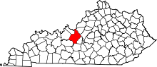 | |
| CDPs | ||
| Other unincorporated communities | ||
| Footnotes | ‡This populated place also has portions in an adjacent county or counties | |