Ratangad
| Ratangad | |
|---|---|
 Ratangad fort from Village Ratanwadi | |
| Highest point | |
| Elevation | 1297 m[1] |
| Coordinates | 19°30′N 73°41′E / 19.5°N 73.69°ECoordinates: 19°30′N 73°41′E / 19.5°N 73.69°E |
| Naming | |
| Translation | रतनगड (Marathi) |
| Geography | |
 Ratangad Location of Ratangad, Maharashtra | |
| Location | Ratan Wadi, Maharashtra, India |
| Parent range | Western Ghats |
| Geology | |
| Mountain type | Hill Fort |
Ratangad (Marathi: रतनगड) is a fort in Ratan Wadi, Maharashtra, India, overlooking the locale of Bhandardara, one of the oldest artificial catchment area. This fort is located in the Ahmadnagar district of Maharashtra. It is on the boundary of Ahmadnagar and Thane districts. The fort is about 2000 years old. This fort is covered with beautiful flowering plants in November.
Places to see
Ratangad has a natural rock peak with a cavity in it at the top which is called 'Nedhe' or 'Eye of the Needle'.The fort has four gates Ganesh, Hanuman, Konkan and Trimbak. It also has many wells on the top.[2] The main attraction at Ratanwadi is the Amruteshwar temple dating back to the Hemadpant Era - roughly from the eighth century.The base village Ratanwadi has an Amruteshwar temple which is famous for its carvings. The fort is origin for the river Pravara/Amrutvahini. The Bhandardara dam(arthar dam) is built on this river.From the top of the fort neighbouring forts like Alang, kulang, Madan gad, Harishchandragad, Patta are seen easily. The view of entire Bhandardara dam( Lake Arthur) gives sheer pleasure.There are many rock cut water cisterns on the fort. Some of them store potable water throughout the year.There is a natural hole in the mountain top probably caused by wind erosion. It is 10 feet high and 60 feet wide. Due to its shape it is called Nedhe (or eye of the needle in Marathi).On the eastern side of the fort there are two caves, which can be used for overnight stay.This fort can be visited in any part of the year however the beast season is from October–February when the temperature is cool and the vegetation has not dried up..
History
Ratangad was captured by Chhatrapati Shivaji Raje Bhosle.
How to reach
There are two main routes to reach the fort. One route starts from village Samrad and the other from village Ratanwadi. The base village Ratanwadi is approached by boat from Bhandardara or by road from Ghoti-Bhandardara road. By boat, it is a 6 km journey and further it is a 4 km walk till Ratanwadi.The trek route from Ratanwadi is the simplest one, it passes through dense forest along the northern bank of the Pravara river, till it reaches a scarp. The final climb is made easy by the iron ladders constructed by the forest department.The local villagers on weekends, erect small shacks on the way to provide tea and snacks for the trekkers.Some villagers provide food and snacks on the fort cave also.The trek route from village Samrad is quite difficult one, it passes over the narrow spur and finally reaches the Trymbak darwaja. This route enthralls the trekkers with joy of seeing the natural beauty and success of completion of the tough challenge. The entire fort can be seen by taking a path which moves around the ridge of the fort.A small group of people can make a overnight stay in the cave on the fort.
Image gallery
 The two ladders that have to be crossed to reach the main fort area
 Nedhe (or eye of the needle)Click here to see its photosphere
 Tryambak Darwaza - The main entrance to Ratangad fort
 The way down from the Tryambak Darwaza
 Another entrance to Ratangad Fort
 The remains of a smaller entrance to the fort - the Thieves entrance or Chor Darwaza
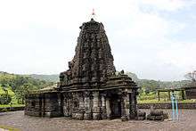 Amruteshwar temple, Ratangad built in the Hemadpanthi style Click here to see its photosphere
 Vishnutirth
 An old structure at the fort
 Ratangad with Ratangad peak(Khutta) at right
 Strobilanthe callosa --Karavy
 Impatiens balsamina --Terada
 Smithia purpurea--Barka
 Senecio bombayensis---Sonki
 Walking along eastern ridge
References
2. Gadkot - Bhagwan Chile, Shivsparsha Prakashan, Kolhapur