Mahim Fort
| Mahim Fort | |
|---|---|
| माहीम किल्ला | |
 Mahim Fort | |
 Location within Mumbai | |
| General information | |
| Type | Fort |
| Location | Mahim, Mumbai |
| Coordinates | 19°02′23″N 72°50′16″E / 19.039848°N 72.837768°E |
| Elevation | 1 m (3 ft 3 in) |
| Current tenants | Encroachments |
| Completed | 16th century |
| Client | Portuguese |
| Owner | Government of Maharashtra[1] |
| Technical details | |
| Structural system | Deccan-trap basalt |
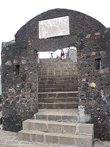
The Mahim Fort (Marathi: माहीम किल्ला) is a fort in Mahim in Mumbai, Maharashtra state, India.[2] Strategically located in the Mahim Bay, the fort overlooks Worli to the south, Bandra to the north, and Mahim to the east. The origins of the fort are unclear, but it occupies a strategic location that has been frequently contested. The fort is currently in disrepair, suffering from administrative neglect, encroachment of slums, and exposure to tidal erosion.
History
In 1516, Portuguese commander Dom Joao de Monoy entered the Mahim Creek and defeated the commander of Mahim fort.[3] The fort was the site of frequent skirmishes between the Portuguese and the Ali Shah, a Gujarati ruler, before the island of Mahim was appropriated from Bahadur Shah of Gujarat by the Portuguese in 1534. In 1661, the Portuguese ceded the island of Mahim as dowry to Charles II of England. After the English gained control of the fort, it was strengthened by Sir Thomas Grantham in 1684,[2] and became a strategic watchtower against possible Portuguese attacks, and later from the Marathas.[2]
In 1772, the Portuguese attempted to attack this fort, but they were repelled by the British with cannonballs.[2] The Mount Mary's Basilica was damaged during this encounter. According to historical accounts, the fort had 100 soldiers and 30 cannons at that time.[2]
The fort was captured by the British during the First Anglo-Maratha War.[4]
Encroachments
The fort lies off the Mahim Causeway which links the suburbs to the city. The fort is heavily encroached by slums, and parts of the fort have caved in due to tidal erosion and neglect. Though the site is classified as a Grade I heritage structure, nothing much has been done to maintain it.[1] Large boulders are strewn on the sand and crevices as high as three metres (fifteen feet) are visible. Responsibility of the fort is shuffled between the state government and the Brihanmumbai Municipal Corporation, although the fort lies of state government land.[1] In 2004, rupees five lakhs had to be returned as the encroachments were not removed by local authorities.[5] Later, in 2008, Jairaj Phatak, the Municipal Commissioner had proposed a makeover to the fort.[6]
Gallery


See also
References
- 1 2 3 Sharan, Abhishek (2003-03-16). "A fortress falls to monumental neglect". Indian Express. Express Group. Retrieved 2008-09-15.
- 1 2 3 4 5 "Mahim Portal". Mahim. Dataflow. Retrieved 2008-09-15.
- ↑ "Section III - Portuguese". Thana District Gazetteer. Retrieved 2008-09-15.
- ↑ Naravane, M.S. (2014). Battles of the Honorourable East India Company. A.P.H. Publishing Corporation. p. 61. ISBN 9788131300343.
- ↑ Choudhury, Chitrangada; Prarthana Gahitole (2004-04-05). "State is failing the caves: Jagmohan". Indian Express. Express Group. Retrieved 2008-09-15.
- ↑ "Phatak proposes a beauty therapy". Daily News and Analysis. Diligent Media Corporation Ltd. 2008-02-05. Retrieved 2008-09-15.
External links
![]() Media related to Mahim Fort at Wikimedia Commons
Media related to Mahim Fort at Wikimedia Commons
| Pre-colonial | |
|---|---|
| Colonial | |
| Beaches | |
| Places of worship | |
| Cultural | |
| Boulevards | |
| Districts | |
| Shopping | |
| Buildings | |
| Parks, zoos and stadia | |
| Museums | |
| Forts | |
| Restaurants & Bars | |