Quebec Route 368
| ||||
|---|---|---|---|---|
 | ||||
| Route information | ||||
| Maintained by Transports Québec | ||||
| Length: | 72.0 km[1] (44.7 mi) | |||
| Major junctions | ||||
| West end: |
| |||
| East end: |
| |||
| Location | ||||
| Major cities: | Quebec City | |||
| Highway system | ||||
| ||||

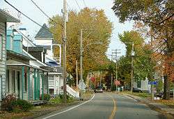
Route 368 in the centre of Saint-Laurent
Route 368 is a 72 km two-lane east/west highway in Quebec, Canada, which is located on Île d'Orléans and includes the Pont de l'Île which connects the island to the mainland. It starts at the junction of Autoroute 40 at exit 325 in Beauport, now part of Quebec City, crosses the bridge and it follows around the island's perimeter, passing through all 6 villages on the island.
On Orleans Island, the route is also known as Chemin Royal (Royal Road) which was completed in 1744.[2]
Towns located along Route 368
- Quebec City (Beauport)
- Saint-Pierre-de-l'Île-d'Orléans
- Sainte-Famille
- Saint-Francois
- Saint-Jean
- Saint-Laurent-de-l'Ile-d'Orleans
- Sainte-Pétronille
See also
References
- ↑ Ministère des transports, "Distances routières", page (?), Les Publications du Québec, 2005
- ↑ "Discover the Island". Courtepointe et Cafe Association of B&Bs on Orleans Island. Retrieved 2009-10-29.
External links
- Provincial Route Map (Courtesy of the Quebec Ministry of Transportation) (French)
- Route 368 on Google Maps
This article is issued from Wikipedia - version of the 11/9/2016. The text is available under the Creative Commons Attribution/Share Alike but additional terms may apply for the media files.