Puente del Inca

Puente del Inca (Spanish "The Inca's Bridge"), is a natural arch that forms a bridge over the Vacas River, a tributary of the Mendoza River. It is located in Mendoza Province, Argentina, near Las Cuevas.
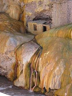
Puente del Inca is also the name of the nearby hot springs. Scientists speculate that interaction of extreme elements like ice and hot springs was involved in the origin of the formation. They suppose that in ancient times ice covered the river and acted as support for avalanches of snow, dust and rocks. So the dust over the ice over the river would have served as a path for the sulfurous water and petrified the surface, so when the snow melted, the bridge remained by itself.
In March 1835, Charles Darwin visited the site, and made some drawings of the bridge with large stalactites.
In the early 20th century there was a large thermal resort and spa that used the hot springs to cure certain illnesses (a spa still survives further down the river at Cacheuta). There was a railway station, which is still standing, and tourists arrived by train to the resort. This was one of the last Argentine stations of the Transandine Railway before the train continued into Chile, traveling through a long tunnel under the Andes.

The area is located between the two trail-heads for climbing Aconcagua, the highest mountain in the western hemisphere. The abandoned railway station has been turned into a mountaineering museum (the "Museo del Andinista"), founded by a group of mountain climbers from Rosario to display the cultural history of the area. The museum is open to the public during the summer and is run by the founding group of friends.[1]
Climate
Situated at 2,740 m (8,990 ft) above sea level, Puente del Inca has a cold semi-arid climate (BSk, according to the Köppen climate classification), with moderate summers and snowy winters.
| Puente del Inca | ||||||||||||||||||||||||||||||||||||||||||||||||||||||||||||
|---|---|---|---|---|---|---|---|---|---|---|---|---|---|---|---|---|---|---|---|---|---|---|---|---|---|---|---|---|---|---|---|---|---|---|---|---|---|---|---|---|---|---|---|---|---|---|---|---|---|---|---|---|---|---|---|---|---|---|---|---|
| Climate chart (explanation) | ||||||||||||||||||||||||||||||||||||||||||||||||||||||||||||
| ||||||||||||||||||||||||||||||||||||||||||||||||||||||||||||
| ||||||||||||||||||||||||||||||||||||||||||||||||||||||||||||
| Climate data for Puente del Inca | |||||||||||||
|---|---|---|---|---|---|---|---|---|---|---|---|---|---|
| Month | Jan | Feb | Mar | Apr | May | Jun | Jul | Aug | Sep | Oct | Nov | Dec | Year |
| Record high °C (°F) | 30.0 (86) |
28.0 (82.4) |
25.0 (77) |
23.5 (74.3) |
21.0 (69.8) |
21.0 (69.8) |
18.5 (65.3) |
17.5 (63.5) |
21.0 (69.8) |
24.0 (75.2) |
25.5 (77.9) |
26.0 (78.8) |
30.0 (86) |
| Average high °C (°F) | 20.7 (69.3) |
19.8 (67.6) |
18.0 (64.4) |
15.0 (59) |
10.2 (50.4) |
5.7 (42.3) |
4.9 (40.8) |
6.1 (43) |
9.1 (48.4) |
11.5 (52.7) |
15.4 (59.7) |
18.5 (65.3) |
12.9 (55.2) |
| Daily mean °C (°F) | 14.3 (57.7) |
13.0 (55.4) |
10.9 (51.6) |
8.0 (46.4) |
4.6 (40.3) |
0.8 (33.4) |
−0.7 (30.7) |
0.6 (33.1) |
3.0 (37.4) |
5.7 (42.3) |
9.7 (49.5) |
12.7 (54.9) |
6.9 (44.4) |
| Average low °C (°F) | 6.8 (44.2) |
5.8 (42.4) |
3.3 (37.9) |
1.2 (34.2) |
−0.9 (30.4) |
−3.8 (25.2) |
−6.0 (21.2) |
−4.7 (23.5) |
−2.9 (26.8) |
−0.7 (30.7) |
2.6 (36.7) |
4.8 (40.6) |
0.5 (32.9) |
| Record low °C (°F) | −8.7 (16.3) |
−10.2 (13.6) |
−11.8 (10.8) |
−15.0 (5) |
−13.7 (7.3) |
−10.6 (12.9) |
−10.7 (12.7) |
−11.5 (11.3) |
−12.6 (9.3) |
−12.4 (9.7) |
−11.7 (10.9) |
−9.7 (14.5) |
−15.0 (5) |
| Average precipitation mm (inches) | 4 (0.16) |
2 (0.08) |
2 (0.08) |
8 (0.31) |
55 (2.17) |
114 (4.49) |
52 (2.05) |
33 (1.3) |
22 (0.87) |
23 (0.91) |
4 (0.16) |
1 (0.04) |
320 (12.6) |
| Average precipitation days | 2 | 2 | 1 | 2 | 7 | 9 | 7 | 6 | 4 | 4 | 2 | 2 | 48 |
| Average snowy days | 0.4 | 0 | 0.4 | 1 | 3 | 7 | 6 | 5 | 4 | 3 | 2 | 0.7 | 32.5 |
| Average relative humidity (%) | 26 | 26 | 25 | 27 | 37 | 50 | 45 | 45 | 41 | 34 | 26 | 24 | 34 |
| Mean monthly sunshine hours | 310.0 | 296.6 | 279.0 | 252.0 | 186.0 | 144.0 | 148.8 | 192.2 | 222.0 | 254.2 | 279.0 | 294.5 | 2,858.3 |
| Percent possible sunshine | 71 | 79 | 73 | 75 | 57 | 48 | 46 | 57 | 62 | 63 | 67 | 67 | 64 |
| Source #1: Servicio Meteorologico Nacional[2] | |||||||||||||
| Source #2: UNLP (sun, extremes and snow only)[3] | |||||||||||||
References
- ↑ (Spanish) Climber's Museum
- ↑ "Datos Estadísticos (Período 1971-1980)" (in Spanish). National Meteorological Service of Argentina. Retrieved August 23, 2012.
- ↑ "Datos bioclimáticos de 173 localidades argentinas". Atlas Bioclimáticos (in Spanish). Universidad Nacional de La Plata. Retrieved April 8, 2014.
External links
Coordinates: 32°49′S 69°55′W / 32.817°S 69.917°W
| Wikimedia Commons has media related to Puente del Inca. |