Porterville, California
| Porterville, California | |||
|---|---|---|---|
| City | |||
| City of Porterville | |||
|
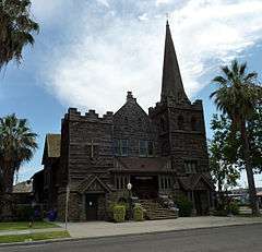
Sierra View District Hospital(top left), Murray Park(top right), Lake Success(middle left), the Historical First Congregational Church(middle right), Statue of the Farmer(bottom left), South County Justice Center(bottom right). | |||
| |||
| Nickname(s): Best City in the World, Pooville, P'ville, Poros, BandTown USA, Gateway to the Sequoia National Monument | |||
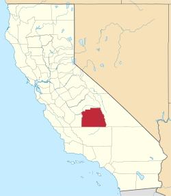
 Location of Porterville in Tulare County and the state of California | |||
 Porterville, California Location in the United States | |||
| Coordinates: 36°4′7″N 119°1′39″W / 36.06861°N 119.02750°WCoordinates: 36°4′7″N 119°1′39″W / 36.06861°N 119.02750°W | |||
| Country | United States | ||
| State | California | ||
| County |
| ||
| CSA | Visalia-Porterville-Hanford | ||
| Metro | Visalia-Porterville | ||
| Incorporated | May 7, 1902[1] | ||
| Government | |||
| • Type | Charter city,[2] Council-Manager | ||
| • City Manager | John D. Lollis[3] | ||
| • Mayor | Juan Jose Beltran Lopez [4] | ||
| • Vice Mayor | Cameron J. Hamilton[4] | ||
| Area[5] | |||
| • City | 17.679 sq mi (45.790 km2) | ||
| • Land | 17.607 sq mi (45.603 km2) | ||
| • Water | 0.072 sq mi (0.188 km2) 0.41% | ||
| • Metro | 4,839 sq mi (12,530 km2) | ||
| Elevation[6] | 459 ft (140 m) | ||
| Population (July 1, 2014)[7] | |||
| • City | 55,466 | ||
| • Density | 3,100/sq mi (1,200/km2) | ||
| • Metro | 459,446 | ||
| • Metro density | 95/sq mi (37/km2) | ||
| Demonym(s) | Porterviller | ||
| Time zone | Pacific (UTC-8) | ||
| • Summer (DST) | PDT (UTC-7) | ||
| ZIP codes | 93257–93258[8] | ||
| Area code(s) | 559[9] | ||
| FIPS code | 06-58240 | ||
| GNIS feature IDs | 1652779, 2411470 | ||
| Website |
www | ||


Porterville is a city in the San Joaquin Valley, in Tulare County, California, United States. It is part of the Visalia-Porterville metropolitan statistical area.
Since its incorporation in 1902, the city's population has grown dramatically as it annexed nearby unincorporated areas. The city's July 2014 population (not including East Porterville) was estimated at 55,466.[7]
Porterville serves as a gateway to a vast wonderland and recreational area, the Sequoia National Forest, the Giant Sequoia National Monument and Kings Canyon National Park.
History
During California's Spanish period, the San Joaquin Valley was considered a remote region of little value. Emigrants skirted the eastern foothills in the vicinity of Porterville as early as 1826. Swamps stretched out into the Valley floor lush with tall rushes or "tulares" as the Indians called them.
Gold discovered in 1848 brought a tremendous migration to California, and prairie schooners rolled through Porterville between 1849 and 1852. Starting in 1854, Peter Goodhue operated a stopping place on the Stockton - Los Angeles Road on the bank of the Tule River. Wagon trains of gold seekers passed through the village, but other travelers found the land rich and remained to establish farms. A store was set up in 1856 to sell goods to miners and the Indians, who lived in tribal lands along the rivers. From 1858 to 1861 it was the location of the Tule River Station of the Butterfield Overland Mail.
Royal Porter Putnam came to the village in 1860 to raise cattle, horses and hogs. Putnam bought out Goodhue in 1860, turning the station into a popular stopping place and hotel called Porter Station. He bought 40 acres of land and built a two-story store and a hotel on the highest point of the swampy property, which is now the corner of Oak and Main. The town of Porterville was founded there in 1864.[10] The town took its name from the founder's given name because another Putnam family lived south of town.
In 1862, 20.8 inches of rain fell in the area causing the change of course of the Tule River. Putnam's acres drained, and he had his property surveyed, staking out lot lines and establishing streets. Settlers were offered a free lot for every one purchased. Needs of a burgeoning California population for food gave the impetus which led to permanent development of the east side southern San Joaquin Valley. The long, dry, hot summer prompted irrigation of the lands.
In 1888, the Southern Pacific Railway brought in the branch line from Fresno. The Pioneer Hotel and Bank were built by businessmen from San Francisco. The town incorporated in 1902, as miners moved into the area to extract magnetite ore, and the Chamber of Commerce was formed in 1907. A City Manager-Council form of government was adopted in 1926, and a Charter was adopted. The City has grown from a community of 5,000 people in 1920. Agriculture supplemented by the Central Valley Water Project has been the major source of economic growth in the area. The City is the center of a large farming area noted especially for citrus and livestock.
Industry has become a significant factor in the development of the community. The Wal-Mart Distribution Center, National Vitamin, Beckman Instruments, Standard Register, Sierra Pacific Apparel, Royalty Carpeting, and other small companies have facilities in Porterville. Several large public facilities are also located here. These include the Porterville Developmental Center, Sequoia National Forest Headquarters, the Army Corps of Engineers Lake Success Facility, and the Porterville College campus of the Kern Community College District.
The Tule River Indian War of 1856
The Native Americans living in the foothills of the Sierra Nevada mountains were relatively undisturbed by early Spanish colonization. During the late 1840s and into the 1850s, once gold was discovered in California, miners began encroaching on traditional lands. Although a treaty was signed with the local tribes in 1851, defining a proposed reservation and two hundred head of cattle per year, the US Senate failed to ratify the treaty, with every member either abstaining or voting no.[11][12]
In the spring of 1856, a rumor that 500 cattle had been stolen by Native Americans began to circulate. Upon further investigation, a single yearling calf had been taken as a bridal gift.[13] Mobs of armed settlers were organized to counter the perceived menace despite the peaceful intentions of the Native Americans. These mobs began raiding Native camps and killing their inhabitants.
One mob, under the leadership of Captain Foster DeMasters, failed to dislodge a numerically-superior Native encampment while wearing ineffective makeshift body armor consisting of cotton-padded jackets.[13][14] Reinforcements were obtained from Keyesville and the resulting force, now under the leadership of Sheriff W.G. Poindexter, were similarly repulsed. After falling back, the mob then proceeded to wage a scorched-earth campaign by destroying Native American supply caches.[13]
News of these engagements spread throughout California, exaggerating the degree of menace and misrepresenting its causes.[14] Finally, in May 1856, army soldiers under the command of LaRhett Livingston assaulted the encampment and succeeded in driving off its defenders. The war's duration was approximately six weeks.
In retrospect, George Stewart wrote "Thus ended the Tule river war of 1856; a war that might have been prevented had there been an honest desire on the part of the white settlers to do so, and one that brought little glory to those who participated therein. The responsibility cannot now be fixed where it properly belongs. Possibly the Indians were to blame. Certainly the whites were not blameless, and it is too seldom, indeed, that they have been in the many struggles with the aboriginal inhabitants of this continent."[13]
Historian Annie Mitchell later wrote in the Tulare County Historical Society bulletin (Los Tulares No. 68, March 1966): "Over the years it has been assumed that the Tule River War was a spontaneous, comic opera affair. It was not and if the Indians had been armed with guns instead of bows and a few pistols they would have run the white men out of the valley."[15]
Geography
Porterville is located at 36°4′7″N 119°1′39″W / 36.06861°N 119.02750°W (36.068550, -119.027536).[16]
According to the United States Census Bureau, the city has a total area of 17.7 square miles (46 km2), of which, 17.6 square miles (46 km2) of it is land and 0.1 square miles (0.26 km2) of it (0.41%) is water.
Porterville is located on the Tule River at the base of the western foothills of the Sierra Nevada and eastern most section of California's Central Valley. In the foothills above Porterville is the man-made Lake Success.
Porterville, lying along the foothills of the Sierras at an elevation of 455 feet, is located on State Highway 65, 165 miles north of Los Angeles, 171 miles east of the Pacific Coast. The City has a strategic central location to major markets and a ready access to major transportation routes
Geology
Porterville is subject to earthquakes and aftershocks due to its proximity to the Pacific Ring of Fire. The geologic instability produces numerous fault lines both above and below ground, which altogether cause approximately 10,000 earthquakes every year. One of the major fault lines is the San Andreas Fault. A few major earthquakes have hit the Porterville area like the Kern County Earthquake of 1952 and the Bakersfield Earthquake of 1952 causing serious aftershocks and earthquakes in the area. All but a few quakes are of low intensity and are not felt.[21] Most of the city are also vulnerable to floods. The San Joaquin Valley and metropolitan areas are also at risk from blind thrust earthquakes.
Climate
Porterville, CA, gets almost 13 inches of rain per year. The US average is 37. Snowfall is 0.01 inches. The average US city gets 25 inches of snow per year. The number of days with any measurable precipitation is 46.
On average, there are 271 sunny days per year in Porterville, CA. The July high is around 100.5 degrees. The January low is 35.6. The comfort index, which is based on humidity during the hot months, is a 54 out of 100, where higher is more comfortable. The US average on the comfort index is 44.
| Climate data for Porterville, California | |||||||||||||
|---|---|---|---|---|---|---|---|---|---|---|---|---|---|
| Month | Jan | Feb | Mar | Apr | May | Jun | Jul | Aug | Sep | Oct | Nov | Dec | Year |
| Average high °F (°C) | 57.9 (14.4) |
63.7 (17.6) |
69.6 (20.9) |
76.7 (24.8) |
84.0 (28.9) |
92.4 (33.6) |
100.5 (38.1) |
98.3 (36.8) |
92.9 (33.8) |
81.4 (27.4) |
69.6 (20.9) |
58.8 (14.9) |
78.82 (26.01) |
| Average low °F (°C) | 35.6 (2) |
39.1 (3.9) |
42.1 (5.6) |
46.3 (7.9) |
51.8 (11) |
57.6 (14.2) |
63.7 (17.6) |
61.8 (16.6) |
56.2 (13.4) |
49.5 (9.7) |
40.7 (4.8) |
36.8 (2.7) |
48.43 (9.12) |
| Average precipitation inches (mm) | 2.17 (55.1) |
1.99 (50.5) |
2.33 (59.2) |
1.0 (25) |
0.5 (13) |
0.14 (3.6) |
0.01 (0.3) |
0.02 (0.5) |
0.35 (8.9) |
0.65 (16.5) |
1.14 (29) |
1.77 (45) |
12.7 (323) |
| Average precipitation days (≥ 0.01 in) | 7.2 | 6.9 | 6.3 | 2.8 | 1.6 | 0.4 | 0.3 | 0.3 | 1.7 | 1.7 | 3.9 | 5.4 | 38.5 |
| Source: NOAA [17] | |||||||||||||
Environmental issues
Owing to geography, heavy reliance on automobiles, and agriculture, Porterville suffers from air pollution in the form of smog. The Porterville area and the rest of the San Joaquin Valley are susceptible to atmospheric inversion, which holds in the exhausts from road vehicles, airplanes, locomotives, agriculture, manufacturing, and other sources. Unlike other cities that rely on rain to clear smog, Porterville gets only 13.00 inches (330.20 mm) of rain each year: pollution accumulates over many consecutive days. Issues of air quality in Porterville and other major cities led to the passage of early national environmental legislation, including the Clean Air Act. More recently, the state of California has led the nation in working to limit pollution by mandating low emission vehicles. Smog levels are only high during summers because it is dry and warm. In the winter, storms help to clear the smog and it is not as much of a problem. Smog should continue to drop in the coming years due to aggressive steps to reduce it, electric and hybrid cars, and other pollution-reducing measures taken.[18]
As a result, pollution levels have dropped in recent decades. The number of Stage 1 smog alerts has declined from over 100 per year in the 1970s to almost zero in the new millennium. Despite improvement, the 2006 annual report of the American Lung Association ranked the city as the 11th most polluted in the country with short-term particle pollution and year-round particle pollution.[19] In 2007 the annual report of the American Lung Association ranked the city as the 4th most polluted in the country with short-term particle pollution and year-round particle pollution.[20] In 2008, the city was ranked the third most polluted and again fourth for highest year-round particulate pollution.[21]
Porterville is also experiencing environmental issues due to California's extreme drought. Most of the city of Porterville has run out of their supply of groundwater, an unfortunate consequence of the entire city relying heavily on private wells. Citizens receive shipments of bottled water and bathe in government-provided public showers.[22]
Demographics
| Historical population | |||
|---|---|---|---|
| Census | Pop. | %± | |
| 1880 | 202 | — | |
| 1890 | 606 | 200.0% | |
| 1910 | 2,696 | — | |
| 1920 | 4,097 | 52.0% | |
| 1930 | 5,303 | 29.4% | |
| 1940 | 6,270 | 18.2% | |
| 1950 | 6,904 | 10.1% | |
| 1960 | 7,991 | 15.7% | |
| 1970 | 12,602 | 57.7% | |
| 1980 | 19,707 | 56.4% | |
| 1990 | 29,563 | 50.0% | |
| 2000 | 39,615 | 34.0% | |
| 2010 | 54,165 | 36.7% | |
| Est. 2015 | 56,058 | [23] | 3.5% |


2010
The 2010 United States Census[25] reported that Porterville had a population of 54,165. The population density was 3,076.3 people per square mile (1,187.77/km²). The racial makeup of Porterville was 31,847 (58.8%) White, 673 (1.2%) African American, 1,007 (1.9%) Native American, 2,521 (4.7%) Asian, 64 (0.1%) Pacific Is lander, 15,482 (28.6%) from other races, and 2,571 (4.7%) from two or more races. Hispanic or Latino of any race were 33,549 persons (61.9%).
The Census reported that 53,018 people (97.9% of the population) lived in households, 207 (0.4%) lived in non-institutionalized group quarters, and 940 (1.7%) were institutionalized.
There were 15,644 households, out of which 8,177 (52.3%) had children under the age of 18 living in them, 8,032 (51.3%) were opposite-sex married couples living together, 2,962 (18.9%) had a female householder with no husband present, 1,315 (8.4%) had a male householder with no wife present. There were 1,424 (9.1%) unmarried opposite-sex partnerships, and 115 (0.7%) same-sex married couples or partnerships. 2,679 households (17.1%) were made up of individuals and 1,193 (7.6%) had someone living alone who was 65 years of age or older. The average household size was 3.39. There were 12,309 families (78.7% of all households); the average family size was 3.78.
The population was spread out with 18,154 people (33.5%) under the age of 18, 5,879 people (10.9%) aged 18 to 24, 14,266 people (26.3%) aged 25 to 44, 10,773 people (19.9%) aged 45 to 64, and 5,093 people (9.4%) who were 65 years of age or older. The median age was 28.8 years. For every 100 females there were 97.9 males. For every 100 females age 18 and over, there were 95.2 males.
There were 16,734 housing units at an average density of 946.5 per square mile (365.4/km²), of which 8,966 (57.3%) were owner-occupied, and 6,678 (42.7%) were occupied by renters. The homeowner vacancy rate was 2.9%; the rental vacancy rate was 6.3%. 30,016 people (55.4% of the population) lived in owner-occupied housing units and 23,002 people (42.5%) lived in rental housing units.
2000
As of the census[26] of 2000, there were 39,615 people, 11,884 households, and 9,174 families residing in the city. The population density was 2,828.4 people per square mile (1,091.8/km²). There were 12,691 housing units at an average density of 906.1 per square mile (349.8/km²). The racial makeup of the city was 49.8% White, 1.3% African American, 1.7% Native American, 4.6% Asian, 0.2% Pacific Islander, 32.7% from other races, and 4.8% from two or more races. Hispanic or Latino of any race were 54.5% of the population.
There were 11,884 households out of which 47.5% had children under the age of 18 living with them, 53.1% were married couples living together, 17.7% had a female householder with no husband present, and 22.8% were non-families. 19.1% of all households were made up of individuals and 8.3% had someone living alone who was 65 years of age or older. The average household size was 3.20 and the average family size was 3.62.
In the city the population was spread out with 34.3% under the age of 18, 10.8% from 18 to 24, 28.0% from 25 to 44, 17.5% from 45 to 64, and 9.4% who were 65 years of age or older. The median age was 29 years. For every 100 females there were 96.4 males. For every 100 females age 18 and over, there were 93.0 males.
The median income for a household in the city was $32,046, and the median income for a family was $35,136. Males had a median income of $31,171 versus $23,737 for females. The per capita income for the city was $12,745. About 20.3% of families and 25.7% of the population were below the poverty line, including 33.7% of those under age 18 and 6.4% of those age 65 or over.
Government
Municipal government
Under the California State Constitution, there is a difference in powers granted to cities. A "General Law City" is one, which operates exclusively under State law. The City Charter, in accordance with the State Constitution, provides the City with authority for "Home Rule" whereby the City is given the power to make and enforce within its own boundaries any law, which does not conflict with the State or Federal Government. The State Constitution gives this right of "Home Rule" to any city.
Porterville has operated as a Charter City since 1926, but the Charter has been changed by the voters several times since then.
During the November 2008 Prop 8 election campaign, Porterville's City Council was the only City Council in all of California that passed a Resolution in favor of Prop 8.[27] The Resolution urged voters to act on behalf of the Council's personal, religious, and political interests.[28] Local gay rights activists, such as Porterville LGBTQ, protested at subsequent City Council meetings for months afterwards, getting the attention of local media.[29] Prop 8 amended California's constitution to remove existing marriage rights for same-sex couples. Porterville, Tulare County voters voted over 75% in favor of Prop 8, among the highest levels in the State of California, during the election.[30] On August 4, 2010, Prop 8 was ruled unconstitutional under the 14th Amendment of the US Constitution. In June 2013, the mayor declared that month to be LGBT pride month,[31] but that proclamation was subsequently rescinded by the city council.[32] The City Council subsequently removed the Mayor responsible for introducing the proclamation, Virginia Gurrola.[33] During a discussion on the establishment of anti-bullying youth safe zones, Gurrola's successor, Cam Hamilton, stated "I’m against bullying, but I’m getting damn tired of it being used as a mantra for everything when all most people have to do is grow a pair and stick up for them damn selves."[34][35]
State and federal representation
In the California State Senate, Porterville is in the 14th district. In the California State Assembly, it is in the 26th Assembly District, represented by Republican Devon Mathis.[36]
In the United States House of Representatives, Porterville is in California's 23rd congressional district, represented by Republican Kevin McCarthy[37]
Infrastructure
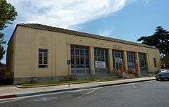
The United States Postal Service operates the Main Post Office on 65 W Mill St, the Town & Country Post Office on 1316 W Olive Ave, the Doyle Colony Post Office on 1391 E Springville Ave, and the Poplar Post Office on 14653 Road 192. The Main Post Office is listed in the National Register of Historic Places.
Economy
Largest employers
According to the City's 2011 Comprehensive Annual Financial Report,[38] the top employers in the city are:
| # | Employer | # of employees |
|---|---|---|
| 1 | Porterville Developmental Center | 1,560 |
| 2 | Porterville Unified School District | 1,475 |
| 3 | Walmart | 1,359 |
| 4 | Sierra View District Hospital | 888 |
| 5 | Eagle Mountain Casino | 512 |
| 6 | City of Porterville | 504 |
| 7 | Foster Farms | 450 |
| 8 | Burton School District | 436 |
| 9 | United States Forest Service - Sequoia National Forest | 371 |
| 10 | Beckman Coulter | 212 |
Local trivia
- The sheriff in Big Top Pee-wee (1988) received a report from Porterville about a windstorm approaching Pee-wee Herman's local town.
- It received the All-America City Award in 1994.[39]
- In the science fiction novel The Santaroga Barrier (1968) Porterville is the nearest "normal town" to the fictional Santaroga situated in a valley 25 miles to the east of Porterville.
- In the science fiction novel Lucifer's Hammer (1977), this city is destroyed by the collapse of the dam at Lake Success.
- Porterville is the home of the Persian Lime
- Porterville has three structures that are listed in the National Register of Historic Places (NRHP); The First Congregational Church, US Post Office- Porterville Main, The Zalud House Museum.
Notable people
- Marv Acton - NASCAR driver
- Barbara Baxley - film, stage and television actress
- Dick Brooks - NASCAR driver
- Brant Brown - Fresno State and Major League Baseball outfielder (Chicago Cubs, Pittsburgh Pirates, and Florida Marlins)
- Tex Clevenger - Fresno State and Major League Baseball pitcher (Boston Red Sox, Washington Senators, Los Angeles Angels, and New York Yankees)
- Steve Cox - Major League Baseball first baseman (Tampa Bay Devil Rays)
- Allen Drury - novelist and 1960 Pulitzer Prize winner
- Wayne Hardin - College Football Hall of Famer, former head football coach at Porterville College 1952 and 1953
- Sim Iness - Oklahoma-born Olympic gold medalist in discus throw
- Joan Marsh - actress
- Monte Moore - Major League Baseball player and Oakland Athletics broadcaster
- Rance Mulliniks - Major League Baseball infielder (California Angels, Kansas City Royals, and Toronto Blue Jays)
- Rick Owens - fashion designer
- Bear Pascoe - football player for Fresno State and NFL's New York Giants
- Charlotte Pendragon International Magician, two time winner of Magician of the Year award
- Helen M. Roberts - writer
- James Sanders - football player for Fresno State and NFL's Atlanta Falcons
- Bill Sharman - NBA Hall of Fame player and coach
- Cam Smith - lead vocalist of international touring band Hotel Books
- Joe Soto - professional mixed martial arts
- Buzz Stephen - MLB pitcher
- Kirsten Vangsness - actress (Criminal Minds)
- Tim Vanni - two-time Olympic wrestler
Transportation
Highways and freeways
California State Route 65, known as The All American City Highway or Porterville Freeway, is a major north-south freeway that heads north to Lindsay and south to Bakersfield. California State Route 190, is a major east west freeway in Porterville that heads west to California State Route 99 and east bypassing East Porterville to Springville.
Major highways
County highways
- (CR J15) – Porterville
- (CR J26) – Porterville
- (CR J27) – Porterville
- (CR J28) – Porterville
- (CR J29) – Porterville
- (CR J37) – Porterville
- (CR J42) – East Porterville
Public transportation
The Porterville Transit operates environmentally-friendly and convenient public transportation to Porterville and the surrounding communities. Porterville COLT Paratranit service designed for transit riders with disabilities that prevent them from using regular bus services. Porterville Transit and COLT services are provided within the city limits and to designated unincorporated urban areas of the county, including "county islands" within the city limits.
The Tulare County Area Transit (TCaT) provides the public transit services between Porterville and smaller communities throughout the greater Porterville Area. Service includes Fixed Route and Demand Responsive services that are offered Monday through Saturday
Air transportation

Porterville has one airport and offers 1 passenger Charter service, WestAir. The Porterville Municipal Airport.(IATA: PTV, ICAO: KPTV, FAA LID: PTV) the nearby commercial airports include:
- (IATA: FAT, ICAO: KFAT, FAA LID: FAT) Fresno Yosemite International Airport, owned by the City of Fresno; serves the San Joaquin Valley.
- (IATA: BFL, ICAO: KBFL, FAA LID: BFL) Meadows Field Airport, also known as Kern County Airport #1, serves the South Valley and the Greater Metropolitan Bakersfield.
Media
Newspaper
The Porterville Recorder is the daily newspaper serving Greater Porterville.
Radio Station
Radio stations KIOO (99.7 FM), KQKL (105.7 FM), KMQA (100.5 FM) and KTIP (1450 AM). We only have one radio station (KTIP ) now and no T.V. station anymore..
Television
TV station KTFF-DT and KVVG-LP are all licensed to Porterville.
Attractions
Golf
- Porterville Municipal Golf Course
- River Island Country Club
Indian gaming
- Eagle Mountain Casino
Museums
- Porterville Historical Museum
- Zalud House
Motorsports
- Porterville off- Highway Vehicle Park
- Rocky Hill Speedway
Performing arts
- Barn Theatre
- Frank "Buck" Shaffer Auditorium (Porterville Memorial Auditorium)
- Deenie's Dance Workshop
- Porterville Community Strings
- Monache High School Band
- Porterville Panther Band
Shopping
- The Porterville Marketplace
- Riverwalk Marketplace
- Mainstreet Boutiques
- Special Occasion Gifts
- Fashion Network
- Earth Angel
Festivals and events
- Band-O-Rama (November)
- Sierra Winter Classic Livestock Jackpot (January
- Orange Blossom Klassic Livestock Jackpot (February)
- Iris Festival (April)
- Porterville Celebrates Reading Fair (April)
- Springville Rodeo (Last Full weekend in April)
- Porterville Fair (May 15–19)
- Springville Apple Festival (October)
- Pioneer Days & Rib Cook-Off (October)
- Annual Veterans Day Parade (November 11)
- Annual Christmas Children's Parade
Outdoor recreation
- Porterville Municipal Pool
- Sequoia National Forest
- Sequoia National Monument
- Tule River Indian Reservation
- Lake Success
- Golden Trout Wilderness Pack Train
- Balch Park Pack Station
- Tule River
- Bartlett Park
Education
Most of Porterville is served by the Porterville Unified School District, while portions of the western section of the city are zoned to the Burton Elementary School District
Schools in the Porterville Unified School DistrictElementary schools
Middle schools
High schools
Alternative high schools
Adult schools
|
Schools in the Burton School DistrictElementary schools
Middle schools
High schools
Alternative schools
|
School Districts of the Greater Porterville area
- Alta Vista Elementary School District east side they are their own district K -8 )
- Burton School District ( they are their own district)
- Citrus South Tule Elementary School District (Closed)
- Ducor Elementary School District
- Hope Elementary School District
- Hot Springs School District
- Lindsay Unified School District
- Pleasant View Elementary School District
- Porterville Unified School District
- Rockford Elementary School District
- Saucelito Elementary School District
- Springville Union Elementary School District
- Strathmore Union Elementary School District
- Sunnyside Union Elementary School District ( own district)
- Terra Bella Elementary School District
- Woodville Union Elementary School District
Higher education
- There is one community college in Porterville, Porterville College (PC), and National University maintains a learning center within Porterville College.
Courts
- Tulare County - District Attorney- Office - 87 East Morton Avenue
- Social Security Administration - Office - 890 West Morton Avenue
South County Justice Center
The new nine-courtroom, 96,000-square-foot courthouse replaced the previous overcrowded Porterville Courthouse. Completed in fall 2013, the $93 million courthouse — which was built by Sundt Construction Inc. and designed by CO Architects — provides the necessary space for expansion and enhanced security, enabling the court to greatly improve access and services.
The facility features chambers, courtroom holdings, jury deliberations rooms, support services, clerks offices and work areas, public walk-up windows and queuing, holding and below-grade sally port. The approximately eight-acre site includes parking and circulation and a featured courtyard scheme.
The courthouse is designed to achieve a LEED Silver certification by the U.S. Green Building Council. The building includes high-performance glass, window-shading devices to prevent direct sunlight, and better insulated walls and roof, and a rain screen system.
It has more energy-efficient mechanical units, which incorporate the partial use of chilled beam passive cooling and radiant heat. The lighting will be high-efficient fluorescent and LED fixtures.
Other sustainable features include: low-use water fixtures and landscape, green roofs, recycling construction materials, the use of regional material and renewable materials as well as certified wood and natural light.
The center was funded under the Trial Court Facilities Act of 2002, made the state of California responsible for court facilities and court construction statewide, and designated a portion of court-user fees and penalties collected to fund the project.
Shopping centers
|
|
Churches
- Porterville Church of the Nazarene (Port Naz)
- Glad Tidings Church
- Calvary Baptist Church
- Porterville Seventh Day Adventist Church
- Hillside Community Church
- First Missionary Baptist Church
- Church of Jesus Christ of Latter-day Saints
- Believer's Church
- First Christian Church
- Gospel Lighthouse Church
- Grace Fundamental Church
- Life Tabernacle-Apostolic Church of Porterville
- Emanuel Evangelical Church
- Trinity Lutheran Church
- Encounter Him Ministries
- Living Word Fellowship Church
- Faith Tabernacle of Porterville
- Family Christian Center
- Church of God
- Masjid Porterville
- Calvary Assembly of God
- St. Anne's Catholic Church
- Holy Cross Catholic Church
- Westfield Christian Church
- Tree of Life Ministries
- Iglesia Del Nazareno
- Porterville Church of Christ
- Porterville Church of Religious Science
- First United Methodist Church
- Grand Avenue United Methodist Church
- First Baptist Church
- Mountain View Baptist Church
- Porterville Seventh Day Adventist Church
- Jehovah's Witnesses
- Henderson Avenue Baptist Church
- New Beginning Assembly of God
- First Assembly of God
Unitarian Universalist Fellowship of Porterville
- Iglesia del Pueblo
- Porterville Christian Center
- Vision Calvary Chapel of Porterville
Parks
|
|
Sister cities
Porterville has two sister cities,
References
- ↑ "California Cities by Incorporation Date" (Word). California Association of Local Agency Formation Commissions. Retrieved August 25, 2014.
- ↑ "Form of Government". City of Porterville. Retrieved November 20, 2014.
- ↑ "City Manager". City of Porterville. Retrieved October 22, 2014.
- 1 2 "City Council". City of Porterville. Retrieved October 8, 2014.
- ↑ "2010 Census U.S. Gazetteer Files – Places – California". United States Census Bureau.
- ↑ "Porterville". Geographic Names Information System. United States Geological Survey. Retrieved October 21, 2014.
- 1 2 "American FactFinder - Results". United States Census Bureau. Retrieved May 18, 2015.
- ↑ "ZIP Code(tm) Lookup". United States Postal Service. Retrieved May 18, 2015.
- ↑ "NPA City Report". North American Numbering Plan Administration. Retrieved November 5, 2014.
- ↑ Mildred Brooke Hoover, Douglas E. Kyle, Historic spots in California, Stanford University Press, 2002, p.543
- ↑ Frank, Gelya. "The Un-ratified treaties of 1851" (PDF). Tule River Tribe. Retrieved October 7, 2014.
- ↑ "ON ADOPTION OF THE RESOLUTION TO ADVISE AND CONSENT TO THE RATIFICATION OF EACH OF THE 18 TREATIES WITH THE INDIAN TRIBES OF CALIFORNIA. (P409 417)". govtrack.us. Retrieved October 7, 2014.
- 1 2 3 4 Menefee, Eugene L; Dodge, Fred A (1913). History of Tulare and Kings Counties California. Retrieved October 7, 2014.
- 1 2 Gorenfeld, William (June 1999). "The Tule River War". Wild West. Retrieved October 7, 2014.
- ↑ Frank, Gelya. "The Tule River Indian War of 1856" (PDF). Tule River Tribe. Retrieved October 7, 2014.
- ↑ "US Gazetteer files: 2010, 2000, and 1990". United States Census Bureau. 2011-02-12. Retrieved 2011-04-23.
- ↑ "NowData - NOAA Online Weather Data". National Oceanic and Atmospheric Administration. Retrieved 2012-02-15.
- ↑ Driveclean from the California Government web site Archived August 7, 2009, at the Wayback Machine.
- ↑ People at Risk In 25 U.S. Cities Most Polluted by Short-Term Particle Pollution. American Lung Association. Retrieved on January 5, 2007.
- ↑ People at Risk In 25 U.S. Cities Most Polluted by Year-Round Particle Pollution. American Lung Association. Retrieved on January 5, 2007.
- ↑ "Pittsburgh and Los Angeles the most polluted US cities".
- ↑ http://www.dailynewsx.com/news/science-news/how-a-california-town-completely-ran-out-of-water-36496.html
- ↑ "Annual Estimates of the Resident Population for Incorporated Places: April 1, 2010 to July 1, 2015". Retrieved July 2, 2016.
- ↑ "Census of Population and Housing". Census.gov. Retrieved June 4, 2015.
- ↑ "2010 Census Interactive Population Search: CA - Porterville city". U.S. Census Bureau. Retrieved July 12, 2014.
- ↑ "American FactFinder". United States Census Bureau. Retrieved 2008-01-31.
- ↑ Avila, Esther (October 7, 2008). "Porterville City Council hears earful on its Prop. 8 decision". Porterville Recorder. Retrieved October 6, 2014.
- ↑ Faison, Glen (October 4, 2008). "Porterville council puts weight behind Prop. 8". Porterville Recorder. Retrieved October 6, 2014.
- ↑ Chandler, Jenna (August 5, 2010). "Overturning of Prop. 8 spurs celebration". Porterville Recorder. Retrieved October 6, 2014.
- ↑ Stackhouse-Hite, Anita (November 9, 2008). "The battle for or against Proposition 8 continues". Porterville Recorder. Retrieved October 6, 2014.
- ↑ Ballard, Kelli (June 4, 2013). "Council proclamation to note Gay Pride Month". Porterville Recorder. Retrieved October 6, 2014.
- ↑ Ballard, Kelli (July 18, 2013). "LGBT Pride month proclamation rescinded". Porterville Recorder. Retrieved October 6, 2014.
- ↑ Ballard, Kelli (September 19, 2013). "Another Changing of the Guards". Porterville Recorder. Retrieved October 6, 2014.
- ↑ Ballard, Kelli (May 8, 2014). "'Safe Zone' idea stirs controversy". Porterville Recorder. Retrieved October 6, 2014.
- ↑ "Porterville back in the spotlight". Porterville Recorder. May 21, 2014. Retrieved October 6, 2014.
- ↑ "Statewide Database". UC Regents. Retrieved November 7, 2014.
- ↑ "California's 23rd Congressional District - Representatives & District Map". Civic Impulse, LLC. Retrieved October 5, 2014.
- ↑ "City of Porterville CAFR" (PDF). Retrieved 2012-12-24.
- ↑ All-America City: Past Winners
- ↑ "US-Japan Sister Cities by State". Asia Matters for America. Honolulu, HI: East-West Center. Retrieved 20 November 2015.