Portage Diversion
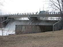


The Portage Diversion (49°56′48″N 98°20′06″W / 49.94667°N 98.33500°W) (also known as the Assiniboine River Floodway) is a water control structure on the Assiniboine River near Portage la Prairie, Manitoba, Canada. The project was made as part of a larger attempt to prevent flooding in the Red River Valley. The Portage Diversion consists of two separate gates which divert some of the flow of water in the Assiniboine River to a 29 km long diversion channel that empties into Lake Manitoba near Delta Beach. This helps prevent flooding on the Assiniboine down river from the diversion, including in Winnipeg, where the Assiniboine River meets the Red River.
During flood years such as the 2011 Assiniboine River flood, inlet flows to the Portage Diversion control structure were measured at over 54,000 cu ft/s (1,500 m3/s). This amount of water would have disastrous effects if left to flood southern Manitoba. During the flood of spring 2011, the Portage Diversion handled roughly half the flow of Niagara Falls.
The Assiniboine River and diking system can handle flows up to approx 10,000 cubic feet per second (280 m3/s) without a serious breach.[1] However, many properties between Portage la Praire and Winnipeg are flooded once the flows exceed 10,500 cfs, including commercial establishments such as the KOA campground in St Francois Xavier. Over the past few years as high river flows have occurred east of Portage la Prairie, residents have noted significant bank erosion and stands of trees decades old are dying off. In recent years government policy has allowed 12,0000 + cfs down the lower assiniboine towards Winnipeg causing major property and environmental damage.
The diversion was originally designed to carry a volume of 25,000 cubic feet per second (710 m3/s). Under a state of emergency in early May 2011, Manitoba authorities did extensive work by raising the dikes and were preparing to send up to 34,000 cu ft/s (960 m3/s) down the diversion channel with bridges downstream being the determining factor in flow rate.,
The diversion was built at a cost of $20.5 million in 1970. The diversion control dam is 35 feet (11 m) high and 1,400 feet (430 m) long and allows 14,600 acre foot (18,000,000 m3) storage.
Flow Rates
Below are data from years of operation of the Portage Diversion when the its use resulted in a 0.5 foot or more rise in Lake Manitoba:
| Year | Peak Flow (cfs) | Volume Diverted (acre-feet) |
|---|---|---|
| 2011 | 34,804 [2] | 4,770,000 |
| 2014 | 34,100 [3] | 2,244,000 |
| 1976 | 26,000 [4] | 1,420,460 [5] |
| 1995 | 13,800 | 1,120,000 |
| 2009 | 21,300 | 932,000 |
| 1999 | 10,500 | 914,000 |
See also
References
- ↑ "Daily Flood Sheet Assiniboine River July 31, 2014" (PDF). Province of Manitoba. 2014.
- ↑ "RED RIVER FLOODWAY OPERATION REPORT SPRING 2011" (PDF). Province of Manitoba. 2011.
- ↑ "Flood Report for Manitoba - July 10, 2014" (PDF). Government of Manitoba. July 10, 2014.
- ↑ "Daily Water Levels and Forecasts Assiniboine River June 22, 2012" (PDF). Province of Manitoba. 2012.
- ↑ "Regulation of Water Levels on Lake Manitoba and along the Fairford River, Pineimuta Lake, Lake St. Martin and Dauphin River and Related Issues" (PDF). The Lake Manitoba Regulation Review Advisory Committee. July 2003.
