Plinth Peak
| Plinth Peak | |
|---|---|
 North face of Plinth Peak | |
| Highest point | |
| Elevation | 2,677 m (8,783 ft) [1] |
| Prominence | 947 m (3,107 ft) [1] |
| Coordinates | 50°38′42.7″N 123°30′38.9″W / 50.645194°N 123.510806°W |
| Geography | |
| Location | British Columbia, Canada |
| Parent range | Pacific Ranges |
| Topo map | NTS 92J/12 |
| Geology | |
| Age of rock | Pleistocene |
| Mountain type | Stratovolcano |
| Volcanic arc/belt | |
| Last eruption | Pleistocene |
| Climbing | |
| First ascent | 1931 N. Carter; A. Dalgleish; T. Fyles; M. Winram[1] |
| Easiest route | rock/ice climb |
Plinth Peak, sometimes called Plinth Mountain, is the highest satellite cone of Mount Meager, and one of four overlapping volcanic cones which together form a large volcanic complex in the Garibaldi Volcanic Belt of the Canadian Cascade Arc. It is one of the most recently formed volcanic formations of the Mount Meager massif.
Plinth Peak is the highest volcanic peak of Mount Meager. Located on the steep north flank of Plinth is the remnant of an inner crater wall that was destroyed by a lateral blast during a period of volcanic activity about 2,350 years ago.
See also
- List of volcanoes in Canada
- List of Cascade volcanoes
- Devastator Peak
- Pylon Peak
- Capricorn Mountain
- Mount Job
- Plinth Assemblage
- Volcanism of Western Canada
- Geology of the Pacific Northwest
References
- 1 2 3 "Plinth Peak". Bivouac.com. Retrieved 20 August 2013.
- Plinth Peak in the Canadian Mountain Encyclopedia.
| British Columbia | 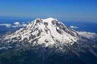 | |
|---|---|---|
| Washington | ||
| Oregon | ||
| California | ||
This article is issued from Wikipedia - version of the 7/5/2015. The text is available under the Creative Commons Attribution/Share Alike but additional terms may apply for the media files.