Mount Tehama
| Mount Tehama Brokeoff Mountain/Volcano | |
|---|---|
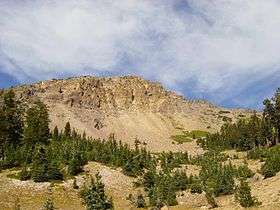 Broken northeast face of Mount Tehama. | |
| Highest point | |
| Elevation | 9,239 ft (2,816 m) NAVD 88[1] |
| Prominence | 915 ft (279 m) [1] |
| Listing | California county high points 17th |
| Coordinates | 40°26′44″N 121°33′34″W / 40.4454368°N 121.5594258°WCoordinates: 40°26′44″N 121°33′34″W / 40.4454368°N 121.5594258°W [2] |
| Geography | |
| Location | Shasta / Tehama counties, California, U.S. |
| Parent range | Cascade Range |
| Topo map | USGS Lassen Peak |
| Geology | |
| Mountain type | Eroded stratovolcano |
| Volcanic arc | Cascade Volcanic Arc |
| Climbing | |
| Easiest route | Hike |
Mount Tehama (also called Brokeoff Volcano or Brokeoff Mountain) is an eroded andesitic stratovolcano in the Cascade Volcanic Arc and the Cascade Range in Northern California. Part of the Lassen volcanic center, its highest remaining remnant, Brokeoff Mountain, is itself the second highest peak in Lassen Volcanic National Park and connects to the park's highest point, Lassen Peak. Located on the border of Tehama County and Shasta County, Tehama's peak is the highest point in the former. The hikers that summit this mountain each year are treated to "exceptional"[3] views of Lassen Peak, the Central Valley of California, and many of the park's other features. On clear days, Mount Shasta can also be seen in the distance.
Tehama started life some 600,000 years ago. At its peak activity, it reached approximately 3,350 meters (11,000 ft) high, with a basal diameter of approximately 12 kilometers. Volcanic activity then declined 400,000 years ago, with other volcanic lava domes forming at the edges of Mount Tehama later on, the largest and best known of which is Lassen Peak. A combination of continued hydrothermal activity and erosion, particularly by glaciers during ice ages, removed the central cone of the volcano, leaving a large caldera, the northern edge of which can still be seen.
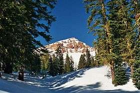
Other remnants of Mount Tehama include Mount Conard, Pilot Pinnacle, Mount Diller, and Diamond Peak.
History
The area near Lassen Peak became a haven for new settlers throughout the 1800s. Wagon trains followed winding trails on the Nobles Emigrant Trail which cut through the Lassen Peak vicinity near Sacramento Valley. One of the main landmarks along this trail was a volcano. Called Lassen Peak after Peter Lassen, a prominent blacksmith and guide who escorted California settlers, the volcano and the area around it were given merit for their gripping volcanic phenomena, which included lava beds and extinct volcanic cones. In May 1907, Lassen Peak was declared a National Monument by President Theodore Roosevelt to protect the area for "future generations to study and enjoy".[4] Roosevelt had been told that the area was actually extinct in terms of eruptive activity. Despite assurance from Native Americans in the area that the mountain was indeed active, settlers continued to think that Lassen Peak was extinct and "dead" and so continued to settle nearby. The natives continued to declare that "one day the mountain would blow itself to pieces".[4] In May 1914, almost exactly seven years later, the volcano began a large explosive eruption sequence. More than a hundred eruptions of varying size took place over the next seven years, attracting national interest and the designation of national park in 1916.[4]
Geography and geology
The state of California is located on the Pacific Ring of Fire, an area of highly active tectonic activity that includes seismicity and volcanism. Tehama and the other volcanoes near Lassen Peak were produced by subduction of the oceanic Pacific Plate under the North American Plate.[5]
Mount Tehama originated in the Lassen volcanic complex, an area of active volcanism for more than three million years. It formed during a period of eruptive activity approximately 600,000 years ago on a series of faults;[6] the largest of these eruptions was about 50 times as powerful as the 1980 eruption of Mount St. Helens. During the Pleistocene, constantly renewed lava of andesite flowed from the caldera of the volcano, eventually becoming "interbedded" and heightening the mountain. By the time it reached its peak size, the volcano was immense, measuring at its base between 11 miles (18 km) and 15 miles (24 km) wide and more than 11,000 feet (3,353 m) tall.[7] Activity at Tehama lasted for approximately 200,000 years. Eruptions varied from ejection of pyroclastic material to andesitic lava flows built of olivine and other minerals.[6]
Soon after the formation of Tehama, other, smaller volcanoes began to form. Shield volcanoes like Raker Peak, Red Mountain, Prospect Peak, and Mount Harkness appeared. At this point, the Pleistocene was coming to an end. One additional and final vent formed on the northeastern flank of the volcano, erupting glassy dacitic flows.[7] Over time, the volcano became dilapidated from extensive erosion and "hydrothermal activity",[6] and collapsed. Prior leaking of dacite dried, forming smaller landforms like Mount Conard and Diamond Peak. The result of this huge collapse was a caldera 2 miles (3 km) in diameter.[4] Later activity built more than thirty other cones known as the Lassen Domes. Today the most active volcano in the area is Lassen Peak. Other smaller craters younger than 50,000 years are also active.[8]
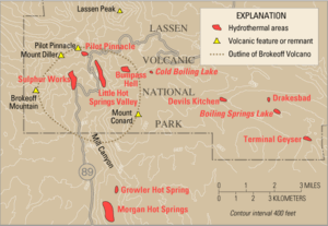
Tehama's remains sit under Mount Lassen in Shasta County, California. Sulphur Works, an area known for its sharp, putrid scent, is thought to be the center of the old caldera. It is located by Diamond Point, the conduit for magmas in Tehama.
After Tehama disappeared, local volcanism became more silicic, moving to Lassen Peak's northern flank. The last 400,000 years have seen at least three known flows, parts of which are still on Raker Peak and Mount Conard. A subsequent explosive eruption ejected 12 cubic miles (50 km3) of material and created a large crater, which was soon covered by lava. Twelve lava domes were built throughout the area and the next period of eruptive activity began. Spanning 50,000 years it ejected 3.5 cubic miles (15 km3) to 6 cubic miles (25 km3) of material and was followed by a third period. At least twelve periods of activity have taken place since Tehama formed, consisting of activity including pyroclastic flows, pasty lavas, and additional lava domes.[6] Among the vents built by this activity include Lassen Peak.[9]
Flora and fauna
Near the trailhead at lower elevations, alder thickets are present, as well as incense cedar, red firs, and western white pine. At higher elevations, groups of mountain hemlock and lupines prevail.[3] Eagles and hawks can be frequently noted on high crags, and squirrels and pika live about the mountain.[10]
Recreation
Hiking is especially popular on the mountain during summer. The mountain trail lasts between four and six hours, spans 7.4 miles (12 km), and offers "exceptional" views of Mount Diller, Lassen Peak, Chaos Crags, and Mount Conard.[3]
Due to the characteristically intermittent eruptions of active volcanoes such as Lassen Peak, there is some threat from the volcanoes of the LVNP. Dacitic explosive eruptions have taken place within the last 50,000 years at Lassen Peak, Chaos Crags, and Sunflower Flat, and effusive eruptions of basalt have occurred at Tumble Buttes, Hat Mountain, and Prospect Peak. Pyroclastic flows and lahars could easily occur near glaciated areas and in river valleys like Hat Creek Valley.[8] In addition to the volcanic hazards that could possibly occur, one volcano did erupt in the 20th century in LVNP: (Lassen Peak). Lassen's eruptions (1914-21, though most activity occurred between 1914-17) were very small compared to the 1980 eruption of Mount St. Helens.
See also
Notes
- 1 2 "Brokeoff Mountain, California". Peakbagger.com. Retrieved 2010-02-03.
- ↑ "Brokeoff Mountain". Geographic Names Information System. United States Geological Survey. Retrieved 2010-02-03.
- 1 2 3 Heid, p. 227.
- 1 2 3 4 Harris, Tuttle, and Tuttle, p. 542.
- ↑ Sinnotte, Barbara.
- 1 2 3 4 Lopes and Lopes, p. 113.
- 1 2 Harris, Tuttle, and Tuttle, p. 549.
- 1 2 Diggles, Michael (May 24, 2005). "Volcano Hazards of the Lassen Volcanic National Park Area, California". United States Geological Survey. Retrieved May 15, 2010.
- ↑ Lopes and Lopes, p. 114.
- ↑ Lopes and Lopes, p. 119.
References
- Harris, Ann G.; Tuttle, Esther, and Tuttle, Sherwood, D. (2004). Geology of National Parks (6th ed.). Dubuque, Iowa: Kendall/Hunt Pub. Co. ISBN 978-0-7872-9970-5. Cite uses deprecated parameter
|coauthors=(help) - Harris, Stephen L. (2005). Fire Mountains of the West: The Cascade and Mono Lake Volcanoes (3rd ed.). Mountain Press Publishing Company. p. 454 pp. ISBN 0-87842-511-X.
- Heid, Matt (2008). 101 Hikes in Northern California: Exploring Mountains, Valley, and Seashore. Wilderness Press. ISBN 978-0-89997-474-3.
- Lopes, Rosaly M. C.; Lopes, Rosaly (2005). The Volcano Adventure Guide. Cambridge University Press. ISBN 978-0-521-55453-4.
- Sinnotte, Barbara (1996). California: A Guide to the State & National. Hunter Publishing, Inc.
- Wood, Charles A.; Jürgen Kienle, eds. (1990). Volcanoes of North America. Cambridge University Press. p. 354 pp. ISBN 0-521-43811-X. Cite uses deprecated parameter
|coauthors=(help)
External links
| Wikimedia Commons has media related to Brokeoff Mountain. |
| British Columbia |  | |
|---|---|---|
| Washington | ||
| Oregon | ||
| California | ||