Piton de la Fournaise
| Piton la Fournaise | |
|---|---|
.jpg) Piton de la Fournaise | |
| Highest point | |
| Elevation | 2,632 m (8,635 ft) |
| Coordinates | 21°14′33″S 55°42′32″E / 21.24250°S 55.70889°ECoordinates: 21°14′33″S 55°42′32″E / 21.24250°S 55.70889°E |
| Naming | |
| Translation | Peak of the Furnace (French) |
| Geography | |
 Piton la Fournaise | |
| Geology | |
| Mountain type | Shield volcano |
| Last eruption | May 2016 (ongoing) |
Piton de la Fournaise (French): "Peak of the Furnace" is a shield volcano on the eastern side of Réunion island (a French department) in the Indian Ocean. It is currently one of the most active volcanoes in the world, along with Kīlauea in the Hawaiian Islands (Pacific Ocean), Stromboli, Etna (Italy) and Mount Erebus in Antarctica. A previous eruption began in August 2006 and ended in January 2007. The volcano erupted again in February 2007, on 21 September 2008, on 9 December 2010, which lasted for two days.[1] and on 1 August 2015.[2] The most recent eruption began on 26 May 2016.[3] The volcano is located within Réunion National Park, a World Heritage site.
Piton de la Fournaise is often known locally as le Volcan (The Volcano); it is a major tourist attraction on Réunion island.
Geography
The top part of the volcano is occupied by the Enclos Fouqué, a caldera 8 kilometers (5.0 mi) wide. High cliffs known as remparts form the caldera's rim. The caldera is breached to the southeast into the sea. It is unstable and is in the initial stages of failure. It will eventually collapse into the Indian Ocean. Whether it will generate a so-called "megatsunami" is controversial. There is evidence on the submerged flanks and abyssal plain of earlier failures. The lower slopes are known as the Grand Brûlé ("Great Burnt"). Most volcanic eruptions are confined to the caldera.
Inside the caldera is a 400 meter high lava shield known as Dolomieu. Atop the lava shield are Bory Crater (Cratère Bory) and Dolomieu Crater (Cratère Dolomieu), named for French geologist Déodat Gratet de Dolomieu, which is by far the wider of the two.
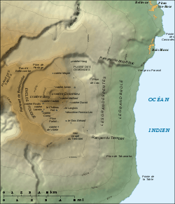
Many craters and spatter cones can be found inside the caldera and the outer flanks of the volcano. At the beginning of the path that leads to the summit, there lies a noticeable small crater known as Formica Leo, named for its similar shape to the pitfall built by the antlion.
Some of the beaches there are of a greenish colour, because of the olivine sand resulting from picrite basalt lavas. The Grand Brûlé is formed from solidified lava flows accumulated over hundreds of thousands of years; the most recent ones are often the darkest and most vegetation-free, while older ones can be covered by dense wild vegetation. Iridium is being ejected through these vents.
This volcano is over 530,000 years old, and for most of its history, its flows have intermingled with those from Piton des Neiges, a larger, older and heavily eroded extinct volcano which forms the northwest two-thirds of Réunion Island. There were three episodes of caldera collapses 250,000, 65,000 and 5,000 years ago. The volcano was formed by the Réunion hotspot, which is believed to have been active for the past 66 million years. There is evidence for explosive eruptions in the past. One explosive eruption about 4,700 years ago may have had a VEI (Volcanic Explosivity Index) of 5, which is the same as the 18 May 1980 eruption of Mount St. Helens.[4]
Eruptions
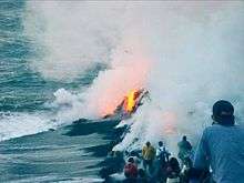


Most eruptions of Piton de la Fournaise are of the Hawaiian style: fluid basaltic lava flowing out with fire fountaining at the vent. Occasionally, phreatic eruptions (groundwater steam-generated eruptions) occur. Lava flows crossing the Grand Brûlé occasionally reach the sea, with spectacular results. Piton de la Fournaise is one of the most active volcanoes in the world, with more than 150 recorded eruptions since the 17th century.
Eruptions within the caldera do not cause much devastation, because the caldera is uninhabited and little infrastructure exists apart from the highway. Lava flows are generally confined to the caldera. However, lava flows have been known to cross the N2 highway; areas where the road was destroyed by the eruption are signposted with the year of eruption after the road is rebuilt. In the early 2000s, the highway thus was destroyed once or more times a year; road engineering services then wait for the lava to cool off and build another stretch of road. It is worth noting that for months after an eruption, the core of the lava flows can still be hot enough to steam in rainy weather.
Eruptions outside of the caldera can pose serious hazards to the population, but are rare. Only six eruptions outside of the caldera have been recorded, most recently in 1986. The village of Piton-Sainte-Rose was evacuated in 1977 before it was inundated by a lava flow which destroyed several buildings. The lava flow crossed the highway and surrounded the local church, entered the front door, then stopped without destroying the building. The front entrance was later cleared out, and the church was brought back into service under the name of Notre-Dame des Laves ("Our Lady of the Lavas").
In April 2007 the volcano erupted and produced an estimated 3,000,000 cubic metres per day. During this eruption 2007 a caldera collapse occurred at the volcano. The collapse displacing 0.8 x 1.1 km floor downward by 330 m, with a volume of 120 million cubic metres. The caldera collapse accompanied one of the largest eruptions of lava at the volcano in the past 100 years.
Monitoring
Volcanic activity is constantly monitored by geophysical sensors (tiltmeters, extensometers, differential GPS receivers, etc.). The data from those various sensors is sent to the Piton de la Fournaise Volcano Observatory, located in Bourg-Murat, northwest of the volcano. The observatory, founded in 1978 following the Piton-Sainte-Rose flow, is operated by the Institut de Physique du Globe de Paris (Global Geophysics Institute of Paris), in association with CNRS and the University of Réunion. The OVPF often publishes reports on Piton de la Fournaise's current activity via their website in French. RIGIC (the Réunion Island Geological Information Center) takes this information and translates it into English for distribution to the English-speaking scientific community.
Procedures specify several levels of alert, which are decided by the prefect of Réunion on the basis of scientific reports:
- Pre-alert: Warnings about possible eruptions; hikers accessing the caldera are warned about possible developments.
- Level 1: An eruption will occur soon; the public may not access the caldera until specialists have examined the situation and set pathways for those willing to admire the eruption.
- Level 2: An eruption is occurring inside the caldera. Access to the caldera is restricted to authorized personnel only.
- Level 3: An eruption is occurring or will occur soon outside of the caldera; some villages may have to be evacuated for safety.
Visit

A high quality forestry road, followed by a track (with lots of bumps), connects the highway of the plains in Bourg-Murat to the Pas de Bellecombe (Bellecombe Pass), where a parking lot and a snack bar are available to visitors. The Pas de Bellecombe is situated over the caldera rim cliffs and offers a good point of view over the northeast part of the caldera.
A good stairway path descends from the pass to the caldera floor. This path is closed for safety reasons during seismic events that may precede eruptions and during eruptions. White paint marks over rocks delimit a number of footpaths ascending the lava shield inside the caldera.
Visitors exploring the caldera should be in good physical condition, with hiking shoes and a supply of drinking water and food. They must be prepared to exercise caution, for the weather can change very quickly, moving from bright sunlight and heat (with risks of heatstroke) to dense fog with cold and rain. In dense fog, straying from paths is very risky. Visitors are advised to take the necessary precautions for sun, heat, cold and rain and not to stray from marked paths.
An excellent, albeit expensive, way to get a good sight of the volcano is to ride in the tourist helicopter flights offered by commercial companies on the island.
The lower parts of the Grand Brûlé can be visited from the N2 highway. Lava flows that have crossed the road are indicated by signs.
Completely free access during eruptions was permitted until 1998; access has been limited since that date, being virtually banned at present.

See also
References
- ↑ "Le Piton de la Fournaise en direct (9 December 2010 – 9 April 2011)" (in French). Observatoire volcanologique du Piton de la Fournaise, Instituts de Physique du Globe de Paris. Archived from the original on 27 April 2011.
- ↑ Klemetti, Erik (2014). "New Eruption at Piton de la Fournaise on Reunion Island". Wired. Archived from the original on 22 June 2014.
- ↑ "Le Piton de la Fournaise est entré en éruption à la Réunion" (in French). Le Figaro. 26 May 2016.
- ↑ "Piton de la Fournaise". Global Volcanism Program. Smithsonian Institution.
External links
| Wikimedia Commons has media related to Piton de la Fournaise. |
- RIGIC (Réunion Island Geological Information Center)
- "Le Piton de la Fournaise". Instituts de Physique du Globe de Paris.
- Reunion Island - anglophone site
