Pirehill Hundred
| Pirehill | |
|---|---|
| History | |
| • Origin | Anglo-Saxon period |
| • Created | 10th century |
| • Abolished | 1894 |
| • Succeeded by | various |
| Status | Obsolete |
| Government | Hundred |
| Subdivisions | |
| • Type | Parishes (see text) |
| • Units | Parishes |
Pirehill is a hundred in the county of Staffordshire, England.
The hundred is located in the north-west and centre of Staffordshire, named after Pire Hill (height 462 ft), a hill two miles south of Stone.[1] The hill was a meeting place for the hundred moot and a rallying point in case of invasion. A large number of hundred names refer to hills or mounds. Some of these at least are very conspicuous hills, which afford a commanding view of the countryside for miles around. It seems likely that such sites were chosen as being remote, and where interference was most easily avoided.[2]

Northern Staffordshire is to a large extent moorland, which must have been unattractive to early settlers. It is noteworthy that the meeting-places of the two northern hundreds (Pirehill and Totmonslow) are in the extreme south of the respective hundreds.[3]
The origin of the hundred dates from the division of his kingdom by King Alfred the Great into counties, hundreds and tithings. From the beginning, Staffordshire was divided into the hundreds of Pirehill, Totmonslow, Offlow, Cuttleston and Seisdon.[4]
Pirehill is one of the largest of the five hundreds of Staffordshire, having an area of 201,493 acres (314 sq.miles), and in the 19th Century the most populous hundred in Staffordshire, with a population in 1861 of 149,734.[5]
It is remarkable for the fertility of its soil, for the beauty and diversity of its scenery and the number and magnificence of its stately homes (the seats of the nobility and gentry), as also for the extent and importance of its manufactures. It contains the long chain of towns and villages called the Potteries, a renowned place of china and pottery manufacturing in the 19th century and later. It also contains Stafford and Stone, which were renowned for shoe manufactutring. It is about 28 miles in length, north to south, and around 8 to 20 miles in breadth. It is bounded on the north-east by Totmonslow (Totmanslow) hundred, on the east by Offlow hundred, on the south by Cuttleston Hundred and on the west and north-west by Shropshire and Cheshire.[6]
.jpg)
The River Trent rises at its northern extremity and flows through it in a south-easterly direction, passing the noble seats of Trentham, Ingestre, Shugborough and Wolseley; and nearly parallel with that river runs the Trent and Mersey Canal. 1t contains the boroughs of Stafford, the county town, Newcastle-under-Lyme and Stoke-on-Trent, which latter includes the Potteries. Besides these, Pirehill has six other market towns: Burslem, Hanley, Lane-End, Stone, Eccleshall and Abbots Bromley.
In the early 19th century it comprised 42 parishes, 14 chapelries and 5 extra-parochial places, which were subdivided into 126 townships and containing several hundred villages and hamlets. It was separated into the north and south divisions, under the control of two chief constables.
The number of the inhabitants nearly doubled during 1801-1831, as a vast augmentation occurred in the Potteries and at Newcastle, Stone and Stafford.
The north and south divisions were of very unequal extent and population. The large parishes of Adbaston, Eccleshall and Seighford, had townships in both divisions, an inconvenience which divided many of their parochial affairs between the two chief constables.
The importance of the hundreds declined from the 17th century, and most of their functions were extinguished with the establishment of county courts in 1867. In 1894 the hundred was made obsolete with the establishment of urban districts and rural districts in Staffordshire.[7]
The population of the hundred, its two divisions and its various parochial units is shown below:[8]
Pirehill North Division
| Parish | Pop. 1831 | Comments |
|---|---|---|
| Adbaston | 601 | |
| Ashley | 825 | |
| Audley | 3,617 | |
| Balterley | 305 | Part of Barthomley parish, mostly Cheshire |
| Betley | 870 | |
| Biddulph | 1,987 | |
| Burslem | 12,714 | |
| Drayton in Hales | 737 | Part of parish, mostly in Shropshire |
| Eccleshall | 4,471 | Including Chapel and Hill Chorlton |
| High Offley | 759 | |
| Keele | 1,130 | |
| Madeley | 1,190 | |
| Maer | 505 | |
| Mucklestone | 964 | |
| Newcastle-under-Lyme | 8,192 | |
| Norton in the Moors | 2,407 | |
| Standon | 420 | |
| Stoke-on-Trent | 37,220 | |
| Swynnerton | 791 | |
| Tentham | 2,344 | |
| Whitmore | 281 | |
| Wolstanton | 10,853 | |
| Total | 93,183 | |
Pirehill South Division
| Parish | Population in 1831 | Comments |
|---|---|---|
| Abbots Bromley | 1621 | |
| Barlaston | 514 | |
| Blithfield | 468 | |
| Chartley Holme | 9 | Extra-parochial area |
| Chebsey | 414 | Including Chebsey: 377 and Cold Borton: 37 |
| Colton | 675 | |
| Colwich | 874 | |
| Cresswell | 11 | Extra-parochial area |
| Ellenhall | 286 | |
| Gayton | 296 | |
| Ingestre | 116 | |
| Milwich | 551 | |
| (Newcastle-under-Lyme) | - | Included under North Division |
| Ranton | 273 | |
| Ranton Abbey | 17 | Extra-parochial area |
| Sandon | 558 | |
| Seighford | 898 | |
| Stafford | 8,512 | See breakdown below |
| Stone | 7,808 | |
| Stowe | 1,283 | |
| Tixall | 176 | |
| Weston under Trent | 498 | |
| Yarlet | 21 | Extra-parochial area |
| Total | 25,879 | |
Parochial areas in the parliamentary borough of Stafford (as from 1832)
| Parish | Population in 1831 | Hundred |
|---|---|---|
| Parishes within the municipal borough | ||
| St Mary (part) and St Chad | 6,956 | Pirehill |
| Castle Church | 1,374 | Cuttleston |
| Townships of St. Mary's parish outside the municipal borough | ||
| Tillington | 42 | Pirehill |
| Hopton & Coton | 642 | Pirehill |
| Worston | 25 | Pirehill |
| Marston | 119 | Pirehill |
| Salt & Enson | 533 | Pirehill |
| Whitgreave | 195 | Pirehill |
| Total | 9,886 | |
| Total within Pirehill Hundred | 8,512 | |
| Total within Cuttleston Hundred | 1,374 | |
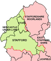
Of the local government districts created in the 1974 re-organisation, Newcastle-Under-Lyme and Stoke-on-Trent (now a unitary authority) fall within Pirehill Hundred, as does the district (or borough) of Stafford except for its southern-most parishes. The districts of Staffordshire Moorlands, East Staffordshire and Lichfield only have one or two parishes each in the hundred.[9]
The Northern Division (91,148 acres) and Southern Division (110,345 acres) were roughly similar in area, but as indicated above, the Northern Division had the vast majority of the population. The Southern Division encompassed an area around Stafford and Stone, now within Stafford District (but not its western-most parishes), with the remainder falling in the Northern Division.[10]
Etymology
The first element is no doubt connected with Middle English piren 'to peer', Modern English peer 'to look narrowly'. The meaning of the name would be 'look-out hill'. Pire Hill is the highest point for some distance; there is nothing higher between it and the river, and it seems to have a good view down the Trent valley. On topographical grounds there is nothing against such a derivation. Old English pirige, pyrige 'pear-tree' may be possible phonologically, but seems less likely for other reasons [11]
Notes
- ↑ See Ordnance Survey map at 52°52'42"N 2°9'30"W. The hill is just west of Pirehill Lane, near the farm and fire station of the same name
- ↑ The English Hundred Names, by Olof Anderson, Lund (Sweden), 1934. Page xxxiii
- ↑ The English Hundred Names, by Olof Anderson, Lund (Sweden), 1934. Page 144
- ↑ A topographical history of Staffordshire, by William Pitt, pub J. Smith (Newcastle -under-Lyme), 1817; page 13
- ↑ Imperial Gazetteer of England and Wales, by John Marius Wilson, 1872
- ↑ See History, Gazetteer and Directory of Staffordshire by William White (1834)
- ↑ See Staffordshire in http://www.visionofbritain.org.uk
- ↑ See History, Gazetteer and Directory of Staffordshire by William White (1834)
- ↑ See www.staffordshire.gov.uk
- ↑ Imperial Gazetteer of England and Wales, by John Marius Wilson, 1872 and www.staffordshire.gov.uk
- ↑ The English Hundred Names, by Olof Anderson, Lund (Sweden), 1934. Page 147