Seighford

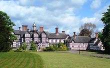
Seighford is a small village about 3 miles (5 km) west of Stafford in Staffordshire, England. The population of this civil parish as taken at the 2011 census was 1,793.[1] The ford across a small stream is the origin of the village's toponym. The village has a red brick Church of England parish church, St Chad's and a 16th-century Tudor mansion.
William White's History, Gazetteer and Directory of Staffordshire (1851) described the village:
Seighford is a scattered village above a small brook which flows east from Latford pool to the River Sow. Its parish contains the hamlets of Aston, Doxey, and Derrington, from one to one and a half miles east, Coton Clanford, one mile south, and Great and Little Bridgeford, three and a half miles north-east of Stafford. It forms a highly cultivated district, containing 803 inhabitants, and 3,830 acre of land. Francis Eld, Esq, is lord of the manor, and owner of most of the soil. He resides at Seighford Hall, an ancient house with modern wings, on the west side of the village…the Parish Church, St Chad, was partly rebuilt of brick about 100 years ago, and contains many neat mural monuments. It has a brick tower, five bells and a clock ... there is a small Wesleyan Chapel at Little Bridgeford, built in 1850."[2]
The village school is Cooper Perry Primary School.
RAF Seighford was a Royal Air Force airfield that was opened in 1943 and closed in 1947. Remains of the control tower and some outbuildings survive.[3] Part of the site is still used by small aircraft, particularly gliders, along with a small runway close to the village of Seighford.
St Chad's
The parish church of St Chad, was partly rebuilt of brick in about 1750. The parish register commences in 1561. The original registers for the period 1561-1879 (baptisms), 1561-1945 (marriages) and 1561-1925 (burials), together with Banns for the period 1754-1812, are deposited at Staffordshire Record Office. Bishop's Transcripts for the period 1661-1850 are deposited at Lichfield Record Office. A transcript of the registers for the period 1561-1812 was published by Staffordshire Parish Register Society in 1978, and has been reprinted by the Birmingham and Midland SGH.[2]
Coordinates: 52°49′N 2°11′W / 52.817°N 2.183°W
Notable people
- Sir (Edwin) Cooper Perry (1856–1938), the only son of Edwin Cresswell Perry (1828–1899), who became vicar of Seighford in 1861. Perry was brought up in the village and became Vice-Chancellor of London University from 1917-19.
References
- ↑ "Civil Parish 2011". Retrieved 6 December 2015.
- 1 2 White, William (1851). History, Gazetteer and Directory of Staffordshire. Sheffield.
- ↑ Control Towers: Seighford
Further reading
- Pevsner, Nikolaus (1974). Staffordshire. The Buildings of England. Harmondsworth: Penguin Books. pp. 232–233. ISBN 0-14-071046-9.
External links
| Wikimedia Commons has media related to Seighford. |