Pančevo Bridge
| Pančevo Bridge Панчевачки мост Pančevački most | |
|---|---|
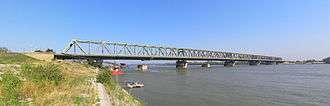 Sideview of the bridge from the right riverside | |
| Official name |
Панчевачки мост Pančevački most |
| Characteristics | |
| Total length | 1,526.4 m |
| Longest span | 162 m |
| History | |
| Opened | November 7, 1946 |
Pančevo Bridge or colloquially Pančevac (Serbian: Панчевачки мост, Pančevački most) is a bridge over the Danube in Belgrade, the capital of Serbia. It was named after the northern Serbian city of Pančevo (in Vojvodina) which is connected to Belgrade by the road continuing from the bridge. Until December 2014 it was the only bridge over the Danube in Belgrade, when another bridge called Pupin Bridge opened further upstream in the municipality of Zemun connecting it to the Banat side of Belgrade.
Location
The bridge is located in the Belgrade municipality of Palilula, which is the only municipality in the city that lies on both banks of the Danube. Geographically, it connects two large regions of Serbia, Šumadija and Banat (Pančevački Rit). The bridge approaches begin well back from the bridge itself in the neighborhoods of Bogoslovija (roundabout at Mije Kovačevića street) and Ada Huja (Višnjička street) and direct approach begins from the Boulevard of Despot Stefan.[1] The bridge spans the neighborhood of Viline Vode, the Danube (at approximately kilometre 1,166 of the river [2]) and reaches the Banat side in the neighbourhood of Krnjača, between the sub-neighborhoods of Blok Braća Marić and Blok Branko Momirov.
History
Construction of the original bridge began in 1933. On October 27, 1935 it was inaugurated by the Prince regent of Yugoslavia, Pavle Karađorđević [3] and named after the still minor King of Yugoslavia, Petar II (Most Kralja Petra II). After the German attack on Yugoslavia on April 6, 1941 in the course of the World War II, the Yugoslav army command decided to blow up all three existing bridges in Belgrade (two over the Sava and one over the Danube) in a vain attempt to slow down the German Army advancement. The Bridge of King Petar II was destroyed on the night of April 10 and 11 1941.
The Germans repaired the bridge for their purposes during the period of occupation in 1941-1944. In the spring of 1944, the Allied Anglo-American bombing of Belgrade began. The bridge was hit and damaged in the bombings of April 16 and September 3, 1944. When the Germans began to withdraw from Belgrade in October 1944, they destroyed the bridge themselves.
Reconstruction of the bridge began in 1945, upstream from the remnants of the destroyed supporting piers. Plans were drawn up by the 50 Soviet engineers headed by Vladimir Aleksandrovich Golovko (1897–1956), lieutenant general of the Red Army's technical troops. Joseph Stalin's orders were that they should build a provisory crossing rather than an expensive railway bridge, but Josip Broz Tito convinced him that a proper bridge should be built. On November 7, 1946, the first train passed over the new bridge and regular road traffic started three weeks later, on November 29. Originally, Tito named it the Bridge of the Red Army (Most Crvene Armije).[4]
After 20 years, in 1965, the bridge had a last major renovation. Not counting the Đerdap dams on the Romanian border, Pančevo Bridge was the only bridge over the Danube in Serbia that was not destroyed by NATO forces during the bombing of Serbia from March 24 to June 12, 1999.
Technical characteristics
The original bridge was built by the German companies Siemens-Baunnion GmbH from Berlin, and Luxemburgische Bergwerks und Hütten AG from Dortmund. The former company supplied the piers for the bridge. The work of these two companies was part of the reparations Germany had to pay to Serbia for the damage inflicted during World War I.
In 1946, the bridge was originally intended to be just a railway bridge but later it was opened for road traffic, too. Today, it has two lanes in both directions for road traffic, and even though it was designed to have two rail tracks as well, at the moment there is only one rail track on the bridge.
Total length of the steel bridge is 1,526.4 meters, of which 1,134,7 meters is over the river bed. The height of the main supporting piers is 18 meters.
Importance
Due to being the only bridge over the Danube in Belgrade for a long time, the bridge became very congested. At its peak Pančevo Bridge had between 150,000 to 200,000 vehicles crossing it daily. When the bridge was rebuilt in 1946, Pančevački Rit (section of Belgrade across the Danube) had a population of 7,998 (1948 Census), Pančevo 26,423 and Belgrade itself 388,246. By the 2002 Census, population figures were 72,704, 77,087 and 1,120,092 respectively.
After crossing into Krnjača, the bridge continues as a road that splits in two directions:
- Pančevo road, 16 kilometers to the east, which leads to the industrial town of Pančevo (after which both the bridge and the road are named) in the province of Vojvodina.
- Zrenjanin road, 77 kilometers to the north, which leads to the town of Zrenjanin, also in Vojvodina.
There are railway stations, "Pančevački most" on the Belgrade side of the bridge, and "Krnjača", on the Krnjača side. Both stations are part of Beovoz commuter rail which connects the area between the town of Stara Pazova in Syrmia region of Vojvodina, Belgrade and Pančevo as this entire area forms a greater metropolitan area of Belgrade.
Future

After 2000, a general consensus was reached that new bridges in Belgrade are a necessity. Belgrade almost doubled after 1974 when the last bridge (Gazela) was built. As for the Pančevački Rit area, which has experienced a tenfold population growth since Pančevo Bridge was built, things are getting even more serious as city government has plans (though distant ones) to move Belgrade Port to the left bank and to begin a project of "Third Belgrade" in this area with 300,000-400,000 inhabitants (the first one is "Old" Belgrade in Šumadija; the second is "New" Belgrade, Novi Beograd-Zemun in Syrmia).[5]
At the moment, even this one bridge is considered to be in a fairly bad shape, as a result of lack of maintenance and overuse. Public debate grew (not just about this bridge) in both expert and lay circles, to the point of publicly expressing views in the mass media on a daily basis about future Belgrade bridges. City government plans to do a complete reconstruction of Pančevo Bridge and build three more bridges over the Danube, to alleviate the traffic pressure on it. One bridge is supposed to be built downstream, to connect the Belgrade suburb of Vinča to Omoljica in the Pančevo municipality. The second bridge is projected for just 1.5 kilometers downstream from Pančevo Bridge and it will connect Ada Huja and Krnjača. The third bridge is to be built upstream and will connect the neighborhoods of Zemun and Borča. Until this last bridge is finished, the city government has proposed a ferry line instead.
However, as of December 2012, only the works on the Zemun-Borča Bridge have begun, scheduled to be finished by the end of 2014.[6] Reconstruction of Pančevo Bridge has been scheduled and postponed several times since 2006. So far, it as only been announced how the reconstruction will be handled.[7] It is supposed to last for 12 months. The rail traffic will be closed during that time. "Beovoz" would stop on the approaches to the bridge and buses would take passengers to the other side. But the bridge will never be fully closed to road traffic, because it would cut Belgrade's only connection across the Danube. Rail tracks will be temporary turned into traffic lanes, which would mean the bridge will have six lanes in this period and two will always be closed for reconstruction. Freight traffic will be allowed only at night.
References
| Wikimedia Commons has media related to Pančevo Bridge. |
- ↑ Beograd - plan i vodič, 3rd edition, "Geokarta", 2007, ISBN 978-86-459-0297-2
- ↑ Turističko područje Beograda, "Geokarta", 2007, ISBN 86-459-0099-8
- ↑ Glas Javnosti - Pančevački most u očajnom stanju
- ↑ "Pančevački most 1946. obnovili Rusi", Politika (in Serbian), p. 11, 2008-04-12
- ↑ Rađanje "trećeg Beograda"
- ↑ "Zemun-Borca bridge to be completed by December 2014". InSerbia Network Foundation. January 22, 2014. Retrieved 4 June 2014.
- ↑ Doneto rešenje za Pančevački most
Coordinates: 44°49′41″N 20°29′31″E / 44.828°N 20.492°E