Palapag, Northern Samar
| Palapag | ||
|---|---|---|
| Municipality | ||
|
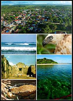
Clockwise from top: Poblacion, Pinsker's hawk-eagle, Palihon Island, crab, ruins of 17th-century Catholic church, Talolora | ||
| ||
 Map of Northern Samar showing the location of Palapag | ||
.svg.png) Palapag Location within the Philippines | ||
| Coordinates: 12°32′49″N 125°06′58″E / 12.547°N 125.116°ECoordinates: 12°32′49″N 125°06′58″E / 12.547°N 125.116°E | ||
| Country |
| |
| Region | Eastern Visayas (Region VIII) | |
| Province | Northern Samar | |
| District | District of Northern Samar | |
| Barangays | 32 | |
| Government[1] | ||
| • Mayor | Manuel J. Aoyang | |
| Area[2] | ||
| • Total | 179.60 km2 (69.34 sq mi) | |
| Population (2015)[3] | ||
| • Total | 34,286 | |
| • Density | 190/km2 (490/sq mi) | |
| Demonym(s) | Palapagnon | |
| Time zone | PST (UTC+8) | |
| ZIP code | 6421 | |
| Dialing code | 55 | |
| Income class | 3rd | |

Palapag is a municipality in the province of Northern Samar, Philippines. It is located in the northernmost part of Samar Island. As of the 2015 census, it has a population of 34,286 people.[3]
Etymology
The name Palapag, according to locals is derived from the word “Palpag” (in the Waray-Waray language it means ‘pounding a post using a wooden stick’ or pulping the bark of a bakhao). The first group of Spaniards who came to Palapag, as they didn’t know the name of the place, they asked in Spanish language to a group of people pulping the bark of a bakhao tree about the name of the place. They thought that they were asked what they were doing, so they answered in vernacular language “nagpapalpag”, which means pulping the bark of a tree. From that time on, the place was called Palpag by the Spaniards.
Geography
Palapag is bounded on the north by the vast Pacific Ocean, on the east by the municipality of Mapanas, on the west by the municipality of Laoang and on the south by the municipality of Catubig. The town center is located in the north-eastern part of the municipality. Its physical features are characterized by mountainous part on the east and a relatively plain on the north-western side of the municipality. Palapag has a total land area of 17,960 hectares (44,400 acres).[2]
Climate/weather
The climate falls under Type 2, no distinct dry season with a very pronounced rainy season, maximum rain period generally occur in December and January. It has an average annual rainfall of 3,000 to 4,000 millimetres (120 to 160 in) per year with an average annual temperature of 26.9 °C (80.4 °F). The warmest month mean temperature is 28 °C (82 °F).
This climate type in Palapag plays an important rule to its agricultural economy. Although the agricultural land area is wide enough for the farmers, mostly the cultivation is being limited by the excessive rainfall and the regular sweeping of the typhoon on Samar Islands.
Barangays
Palapag is subdivided into 32 barangays.[2]
- Asum (Pob.)
- Bagacay
- Bangon
- Benigno S. Aquino, Jr. (Pob.)
- Binay
- Cabariwan
- Cabatuan
- Campedico
- Capacujan
- Jangtud
- Laniwan (Pob.)
- Mabaras
- Magsaysay
- Manajao
- Mapno
- Maragano
- Matambag
- Monbon
- Nagbobtac
- Napo
- Natawo
- Nipa
- Osmeña
- Pangpang
- Paysud
- Sangay
- Simora
- Sinalaran
- Sumoroy
- Talolora
- Tambangan (Pob.)
- Tinampo (Pob.)
History
Pre-Hispanic
In the southernmost part of Samar lies the town of what is now Guiuan. From there the first wave of settlers of what is now Palapag came consisted of ten families and settled first on what is now Mapno, a coastal Barangay. The leader of these settlers named Tinadyao founded the town. The place where the town located was called by the natives as "patag" which means plain. Later on, another wave of settlers came also from Eastern Samar joined the first settlers. The leader of this second wave of settlers was Macatalo Macapongo.[4]
Spanish Era
Arrival of the Jesuit Missionaries
On the year 1585, during the reign of Spanish Governor-General Don Santiago De Vera, the Spaniards established Palapag as pueblo and named it Palpag. Later on, it was renamed as Palapag, the present name of the town.
The responsibility of bringing the Gospel on the Island of Samar was tasked to Fathers Francisco Otaco, Bartolome Martes and Brother Domingo Alonso on October 15, 1596. They first established their mission residence in Tinago (Tarangnan) on the western coast of Samar. At that time, Tinago was one of the most ancient and most populated villages upon the arrival of the Jesuits. On 1598, a fine church was built in Tinago and six other smaller ones were constructed near the mission residence.
When the people of Palapag heard and learned about the wonderful things that happened in Tinago and on the entire western coast of Samar, they started to appeal with the missionaries to establish a mission residence in their villages. Because of this appeal, the Jesuits sent a small group of missionaries to Palapag.[5]
Palapag Royal Port

The Royal Port of Palapag and the Manila Galleons
The people of Palapag or Ibabao and the missionaries played an all-important role in sheltering and securing the richly laden Manila galleons returning from Acapulco, Mexico.
The first trans-Pacific voyage of galleon occurred on 1565. For some two hundred and fifty years, the treasure laden vessels sailed almost annually in the Pacific Ocean contended with the disease, scurvy, beriberi, hunger, sea storms, and Dutch and English piracy. It was vital both economically and spiritually to the Spanish outpost. The galleon shipped spices to Mexico from Manila and upon returning from America, the vessels were loaded with wealth doubled when it left Manila.
Throughout the period of galleon trade, Palapag Port harbored these richly-laden ships from Moro and Dutch pursuits. Sometimes these vessels sought refuge from unfavorable winds or seas or merely drop their anchor for water, food or fuel then continue their voyage though the San Bernardino Strait.
These ports were located off the coast of Palapag. The first one was on the outskirts called Cajayagan and the other one the so-called inner ports which were more secure than the first was called Calomotan. From there, the galleon continued their voyage passing the villages of Catarman and Bobon and made a stopover in the island of Biri, where they either watched the tide or unload the parcel of their cargo then proceeded to the Strait of San Bernardino.[6]
Provincial and Municipal Government
By 17th Century, Spanish colonist numbered only a few thousand throughout the Philippines had little incentives to settle and carve out the land in the provinces. On the Island of Samar, the land and people were distributed among the Spanish colonists under the encomienda system.[7] A Spanish who was trusted with encomienda was called encomendero. He was tasked to collect tributes, recruit abled-bodied males for public services or polo and ensure the physical and spiritual well-being of the inhabitants. But because of abuses, the system was abolished.
In order to enhance their administration on the colony, the Spaniards did not abolish the old barangays and merged it into towns called pueblos and the groups of pueblos were called alcadia or districts headed by alcalde mayor.[8]
When the Jesuits were expelled in Samar in 1768, there were sixteen pueblos had already established but only fifteen pueblos had Jesuit parish priest resident and were already divided into three residences, the east, north and the west coasts. The center of the north-east coasts referred to as Ibabao, was Palapag, while for the west coast was Catbalogan and at the same time the capital of Samar Island.[9] Being the capital, it was there where the provincial government personnel numbering no more than three or four Spaniards including the governor. His prime duty was to collect revenues, pay the accounts and balance the books. He had executives, judicial and legislative functions.
As of 1830, a royal order was issued substituting civilian governor by a military governor. He assumed office on 1830 as the first military governor of Samar and the number of government personnel was increased. For administrative purposes, he suggested the division of Samar into three administrative districts, the west, north and the east coasts. It was approved on 1867 in Manila and in the Council of Administration in Madrid, however it was not realized. By 1890, the Franciscans divided Samar into three vicariates, the west, north and east coasts.
On the municipal level, the pueblo was headed by a Gobernadorcillo elected annually. He was both the judicial and executive officer, the general supervisor and ensure of public order, the main collector of tributes and in charge of the repair and maintenance of public buildings and roads. In order to perform his task efficiently he had to work closely with the priest for support and visto bueno of documents. His subordinates were called cabeza de baranagay who was in charge of collecting tributes and other taxes of each family. Aside from them, there were also three superintendents and assistants of fields, livestock, police and lieutenants (tenientes) and police for every visita and barrio. With the increased of pueblo officials the role of the priest was reduced.[10]
Demographics
| Population census of Palapag | ||
|---|---|---|
| Year | Pop. | ±% p.a. |
| 1990 | 20,114 | — |
| 1995 | 24,947 | +4.12% |
| 2000 | 30,520 | +4.42% |
| 2007 | 31,398 | +0.39% |
| 2010 | 33,453 | +2.33% |
| 2015 | 34,286 | +0.47% |
| Source: National Statistics Office[3][11] | ||
Transportation
The municipality is not directly connected by land to other regions of the Philippine archipelago; it still relies on the wharfs provided by the Barangay’s near coastal areas (Brgy. Sumoroy and Brgy. Pangpang) through motorized boats on going to and from the town. It has a small port in Brgy. Mapno but currently idle, no facilities yet provided for the port users.
Education
Elementary:
- Palapag Central Elementary School
- Cabatuan Elementary School
Secondary:
- Sumoroy Agro-Industrial School
- Capacujan National High School
- Cabatuan National High School
- Pangpang National High School
- Jangtud National High School
Tertiary:
- Eastern Visayas Central Colleges (EVCC)
- Colegio de Nuestra Seniora de la Assuncion
References
- ↑ "Municipalities". Quezon City, Philippines: Department of the Interior and Local Government. Retrieved 18 April 2013.
- 1 2 3 "Province: Northern Samar". PSGC Interactive. Makati City, Philippines: National Statistical Coordination Board. Retrieved 18 April 2013.
- 1 2 3 "Total Population by Province, City, Municipality and Barangay: as of May 1, 2010" (PDF). 2010 Census of Population and Housing. National Statistics Office. Retrieved 18 April 2013.
- ↑ Historical Data Papers of Palapag (from Philippine National Library), p. 1.
- ↑ Vilches, Maria Luz (1979). Reading in Leyte-Samar History. DWU. pp. 32–34.
- ↑ Vilchez, Op. Cit., pp. 34–36.
- ↑ Vilchez, Op. Cit.,. p. 43.
- ↑ Philippine History and Government. Manila: IBON Foundations, Inc. 1999. pp. 64–66.
- ↑ Cruikshank, Robert Bruce (1975). A History of Samar Island, 1768 - 1898 (Unpublished Doctoral Thesis, University of Wisconsin, USA, 1975). pp. 18–19.
- ↑ Ibid. pp. 18–19.
- ↑ "Province of Northern Samar". Municipality Population Data. LWUA Research Division. Retrieved 14 August 2013.
External links
- Philippine Standard Geographic Code
- Philippine Census Information
- Local Governance Performance Management System
 |
Philippine Sea | | ||
| Laoang | |
Philippine Sea | ||
| ||||
| | ||||
| Catubig | Mapanas |
Catarman (capital) | |
| Municipalities | |