Packwood Creek
| Packwood Creek | |
| Country | United States |
|---|---|
| State | California |
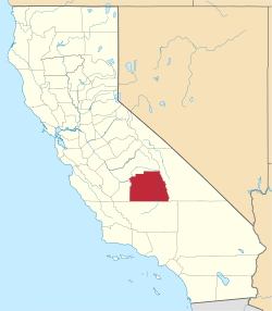
| County | Tulare County |
| Source | |
| - location | Visalia, California |
| - elevation | 272 ft (83 m) |
| - coordinates | 36°20′12″N 119°13′23″W / 36.33667°N 119.22306°W [1] |
| Mouth | |
| - location | Tulare, California, United States |
| - elevation | 272 ft (83 m) |
| - coordinates | 36°15′42″N 119°25′58″W / 36.26167°N 119.43278°WCoordinates: 36°15′42″N 119°25′58″W / 36.26167°N 119.43278°W [1] |
 Location of Packwood Creek in California
| |
Packwood Creek is one of the four main creeks that flow through the city of Visalia and the surrounding communities.
History
Packwood Creek was named after Elisa Packwood.[2]
See also
References
- 1 2 U.S. Geological Survey Geographic Names Information System: Packwood Creek
- ↑ Annie R. Mitchell, Land of the Tules: The Early Years of Tulare County, Interesting Facts About Our County (Fresno, California: 1972): 78.
This article is issued from Wikipedia - version of the 9/11/2016. The text is available under the Creative Commons Attribution/Share Alike but additional terms may apply for the media files.