Owen, Wisconsin
| Owen, Wisconsin | |
|---|---|
| City | |
|
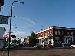
The old downtown, looking north up Central Avenue toward the Owen Company's Woodland Hotel | |
 Location of Owen, Wisconsin | |
| Coordinates: 44°56′54″N 90°33′53″W / 44.94833°N 90.56472°WCoordinates: 44°56′54″N 90°33′53″W / 44.94833°N 90.56472°W | |
| Country | United States |
| State | Wisconsin |
| County | Clark |
| Area[1] | |
| • Total | 1.84 sq mi (4.77 km2) |
| • Land | 1.77 sq mi (4.58 km2) |
| • Water | 0.07 sq mi (0.18 km2) |
| Elevation[2] | 1,243 ft (379 m) |
| Population (2010)[3] | |
| • Total | 940 |
| • Estimate (2012[4]) | 930 |
| • Density | 531.1/sq mi (205.1/km2) |
| Time zone | Central (CST) (UTC-6) |
| • Summer (DST) | CDT (UTC-5) |
| Area code(s) | 715 & 534 |
| FIPS code | 55-60825[5] |
| GNIS feature ID | 1577195[2] |
| Website |
cityofowen |
Owen is a city in Clark County in the U.S. state of Wisconsin. The population was 940 at the 2010 census. Owen is located directly east of the village of Withee, which is about half the size of Owen.
History
In 1880 the Wisconsin Central Railroad built its line through what would become Owen, on its way from Abbotsford to Chippewa Falls.[6]
In 1893 the John S. Owen Company of Eau Claire managed to buy from J.D. Spaulding 400 square miles of virgin timber that ran from the current site of Owen north through Taylor County and into Rusk County. Near where the railroad crossed Brick Creek and that creek flowed into the Popple River, the company built a warehouse, a boarding house, and five log buildings clustered around the rail line. They dammed Brick Creek to make a mill pond and built a sawmill, a planing mill, and a company store. A one-room school was built in 1894. Early on, John's son Aloney moved to the settlement to oversee local operations.[6]
In 1904 the Village of Owen incorporated, with 315 people. In 1906 the Owen Company started the Owen Box and Crating factory and the Woodland Hotel. In 1907 the Owens organized the State Bank of Owen, headed by J.G. Owen.[6]
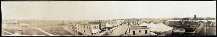
By 1914, Owen's population was 1,000. The Owens organized the State Bank of Withee, headed by A.R. Owen. The Owens also had a hand in a bottling works, a theater, a telephone company, and three hotels. They donated land for a city park and churches. In 1915 the company opened a retail lumber store.[6]
By 1918 the Owen Company was running 25 miles of railroad in Clark and Taylor Counties, hauling logs from their timber holdings in to their sawmill. At one point they thought their supply might last for five or six years, but it ended up lasting 40. The last log was sawed in 1932.[6]
Geography
Owen is located at 44°56′54″N 90°33′53″W / 44.94833°N 90.56472°W (44.948330, -90.564740).[7]
According to the United States Census Bureau, the city has a total area of 1.84 square miles (4.77 km2), of which, 1.77 square miles (4.58 km2) is land and 0.07 square miles (0.18 km2) is water.[1]
Demographics
| Historical population | |||
|---|---|---|---|
| Census | Pop. | %± | |
| 1910 | 745 | — | |
| 1920 | 1,083 | 45.4% | |
| 1930 | 1,102 | 1.8% | |
| 1940 | 1,083 | −1.7% | |
| 1950 | 1,034 | −4.5% | |
| 1960 | 1,098 | 6.2% | |
| 1970 | 1,031 | −6.1% | |
| 1980 | 998 | −3.2% | |
| 1990 | 895 | −10.3% | |
| 2000 | 936 | 4.6% | |
| 2010 | 940 | 0.4% | |
| Est. 2015 | 930 | [8] | −1.1% |
2010 census
As of the census[3] of 2010, there were 940 people, 419 households, and 252 families residing in the city. The population density was 531.1 inhabitants per square mile (205.1/km2). There were 485 housing units at an average density of 274.0 per square mile (105.8/km2). The racial makeup of the city was 96.7% White, 0.5% African American, 0.1% Native American, 0.1% Asian, 2.0% from other races, and 0.5% from two or more races. Hispanic or Latino of any race were 3.8% of the population.
There were 419 households of which 27.7% had children under the age of 18 living with them, 44.4% were married couples living together, 8.4% had a female householder with no husband present, 7.4% had a male householder with no wife present, and 39.9% were non-families. 35.8% of all households were made up of individuals and 16.2% had someone living alone who was 65 years of age or older. The average household size was 2.23 and the average family size was 2.87.
The median age in the city was 40.4 years. 23.7% of residents were under the age of 18; 8.8% were between the ages of 18 and 24; 22.1% were from 25 to 44; 25.5% were from 45 to 64; and 19.9% were 65 years of age or older. The gender makeup of the city was 48.2% male and 51.8% female.
2000 census
As of the census[5] of 2000, there were 936 people, 412 households, and 255 families residing in the city. The population density was 510.9 people per square mile (197.5/km²). There were 455 housing units at an average density of 248.4 per square mile (96.0/km²). The racial makeup of the city was 98.61% White, 0.64% African American, 0.43% Native American, 0.11% Asian, and 0.21% from two or more races. Hispanic or Latino of any race were 0.43% of the population.
There were 412 households out of which 26.5% had children under the age of 18 living with them, 48.3% were married couples living together, 10.2% had a female householder with no husband present, and 37.9% were non-families. 32.3% of all households were made up of individuals and 21.6% had someone living alone who was 65 years of age or older. The average household size was 2.27 and the average family size was 2.84.
In the city the population was spread out with 23.3% under the age of 18, 9.1% from 18 to 24, 23.9% from 25 to 44, 20.6% from 45 to 64, and 23.1% who were 65 years of age or older. The median age was 41 years. For every 100 females there were 90.2 males. For every 100 females age 18 and over, there were 86.5 males.
The median income for a household in the city was $27,368, and the median income for a family was $37,955. Males had a median income of $27,431 versus $20,547 for females. The per capita income for the city was $14,981. About 9.4% of families and 13.4% of the population were below the poverty line, including 19.4% of those under age 18 and 13.8% of those age 65 or over.
References
- 1 2 "US Gazetteer files 2010". United States Census Bureau. Retrieved 2012-11-18.
- 1 2 "US Board on Geographic Names". United States Geological Survey. 2007-10-25. Retrieved 2008-01-31.
- 1 2 "American FactFinder". United States Census Bureau. Retrieved 2012-11-18.
- ↑ "Population Estimates". United States Census Bureau. Retrieved 2013-06-24.
- 1 2 "American FactFinder". United States Census Bureau. Retrieved 2008-01-31.
- 1 2 3 4 5 Lacey, Patricia A. (July 2004). "Owen High School" (PDF). National Register of Historic Places - Registration Form. US Dept. of the Interior - National Park Service. Retrieved 2016-05-01.
- ↑ "US Gazetteer files: 2010, 2000, and 1990". United States Census Bureau. 2011-02-12. Retrieved 2011-04-23.
- ↑ "Annual Estimates of the Resident Population for Incorporated Places: April 1, 2010 to July 1, 2015". Retrieved July 2, 2016.
- ↑ "Census of Population and Housing". Census.gov. Retrieved June 4, 2015.
External links
| Wikimedia Commons has media related to Owen, Wisconsin. |
Municipalities and communities of Clark County, Wisconsin, United States | ||
|---|---|---|
| Cities |  | |
| Villages | ||
| Towns | ||
| CDPs | ||
| Unincorporated communities | ||
| Ghost towns | ||
| Footnotes | ‡This populated place also has portions in an adjacent county or counties | |