Old U.S. Route 64 (Menifee, Arkansas)
|
Old U.S. Route 64, Menifee Segment | |
 | |
  | |
| Nearest city | Menifee, Arkansas |
|---|---|
| Coordinates | 35°8′52″N 92°33′16″W / 35.14778°N 92.55444°WCoordinates: 35°8′52″N 92°33′16″W / 35.14778°N 92.55444°W |
| Area | 1.1 acres (0.45 ha) |
| Built | 1931 |
| MPS | Arkansas Highway History and Architecture MPS |
| NRHP Reference # | 06000071[1] |
| Added to NRHP | March 2, 2006 |
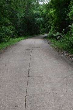
Old U.S. Route 64 is a historic former alignment of U.S. Route 64 (US 64) in Menifee, Arkansas. Now a portion of Canal Road, it consists of a 0.5-mile (0.80 km) section of concrete pavement, extending south from the current alignment of US 64 near the center of Menifee. Built in 1931, it is the longest intact portion of the highway's original alignment in Conway County. It was bypassed by the present alignment in 1961.[2]
The road section was listed on the National Register of Historic Places in 2006.[1]
See also
References
- 1 2 National Park Service (2010-07-09). "National Register Information System". National Register of Historic Places. National Park Service.
- ↑ "NRHP nomination for Old US 64, Menifee Segment" (PDF). Arkansas Preservation. Retrieved 2016-04-12.
| Topics | |
|---|---|
| Lists by states |
|
| Lists by insular areas | |
| Lists by associated states | |
| Other areas | |
| |
This article is issued from Wikipedia - version of the 12/2/2016. The text is available under the Creative Commons Attribution/Share Alike but additional terms may apply for the media files.