| [3] |
Name on the Register[4] |
Image |
Date listed[5] |
Location |
City or town |
Description |
|---|
| 1 |
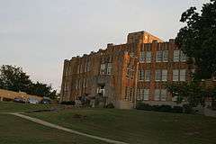
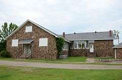
Arkansas Christian College Administration Building |
|
000000002014-01-22-0000January 22, 2014
(#13001101) |
100 W. Harding St.
35°09′51″N 92°44′36″W / 35.164123°N 92.743223°W / 35.164123; -92.743223 (Arkansas Christian College Administration Building) |
Morrilton |
|
| 2 |
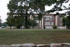
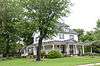
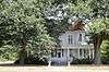
Aycock House |
|
000000001976-05-13-0000May 13, 1976
(#76000397) |
410 W. Church St.
35°09′06″N 92°45′01″W / 35.151667°N 92.750278°W / 35.151667; -92.750278 (Aycock House) |
Morrilton |
|
| 3 |
Cafeteria Building-Cleveland School |
|
000000001992-09-10-0000September 10, 1992
(#92001194) |
County Road 511
35°23′27″N 92°42′41″W / 35.390833°N 92.711389°W / 35.390833; -92.711389 (Cafeteria Building-Cleveland School) |
Cleveland |
|
| 4 |
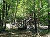
Cedar Creek Bridge |
|
000000001990-04-09-0000April 9, 1990
(#90000520) |
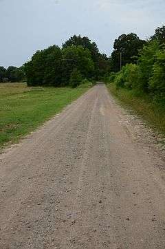
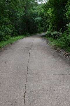
Off Highway 154, over Cedar Creek at Roosevelt Lake
35°07′43″N 92°55′30″W / 35.128611°N 92.925°W / 35.128611; -92.925 (Cedar Creek Bridge) |
Petit Jean State Park |
|
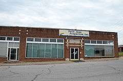
| 5 |
Coca-Cola Building |
|
000000001982-12-22-0000December 22, 1982
(#82000803) |
211 N. Moose
35°09′15″N 92°44′35″W / 35.154167°N 92.743056°W / 35.154167; -92.743056 (Coca-Cola Building) |
Morrilton |
|
| 6 |
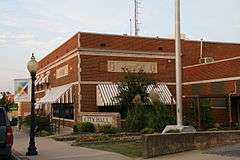
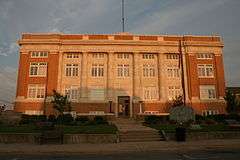
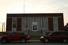
Conway County Courthouse |
|
000000001989-11-13-0000November 13, 1989
(#89001960) |
Moose St. at Church St.
35°09′05″N 92°44′37″W / 35.151389°N 92.743611°W / 35.151389; -92.743611 (Conway County Courthouse) |
Morrilton |
|
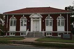
| 7 |
Conway County Library |
|
000000001978-04-15-0000April 15, 1978
(#78000581) |
101 W. Church St.
35°09′04″N 92°44′45″W / 35.151111°N 92.745833°W / 35.151111; -92.745833 (Conway County Library) |
Morrilton |
|
| 8 |
Cove Creek Bridge |
Upload image |
000000002004-05-24-0000May 24, 2004
(#04000499) |
Highway 124
35°19′23″N 92°29′08″W / 35.323056°N 92.485556°W / 35.323056; -92.485556 (Cove Creek Bridge) |
Martinville |
|
| 9 |
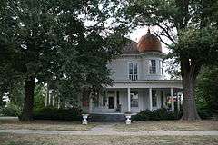
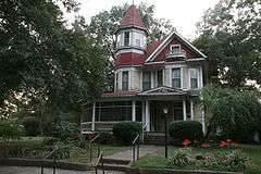
Cox House |
|
000000001974-10-22-0000October 22, 1974
(#74000471) |
Bridge St.
35°08′30″N 92°44′06″W / 35.141667°N 92.735°W / 35.141667; -92.735 (Cox House) |
Morrilton |
|
| 10 |
Earl Building |
|
000000002009-01-22-0000January 22, 2009
(#08001336) |
201 N. St. Joseph St.
35°09′12″N 92°44′28″W / 35.1534°N 92.7411°W / 35.1534; -92.7411 (Earl Building) |
Morrilton |
|
| 11 |
First National Bank of Morrilton |
|
000000001982-12-22-0000December 22, 1982
(#82000804) |
Main at Moose St.
35°09′10″N 92°44′38″W / 35.152778°N 92.743889°W / 35.152778; -92.743889 (First National Bank of Morrilton) |
Morrilton |
|
| 12 |
Grotto, Petit Jean No. 8 |
Upload image |
000000001982-05-04-0000May 4, 1982
(#82002100) |
Address Restricted
|
Oppelo |
|
| 13 |
Hardison Shelter, Petit Jean No. 3 |
Upload image |
000000001982-05-04-0000May 4, 1982
(#82002101) |
Address Restricted
|
Oppelo |
|
| 14 |
Indian Cave, Petit Jean No. 1 |
Upload image |
000000001982-05-04-0000May 4, 1982
(#82002102) |
Address Restricted
|
Oppelo |
|
| 15 |
Little Rock to Cantonment Gibson Road-Old Wire Road Segment |
|
000000002008-03-27-0000March 27, 2008
(#07001465) |
Old Wire Rd., southwest of Blackwell
35°12′47″N 92°50′45″W / 35.213118°N 92.845827°W / 35.213118; -92.845827 (Little Rock to Cantonment Gibson Road-Old Wire Road Segment) |
Blackwell |
A Trail of Tears site[6]
|
| 16 |
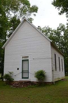
Mallettown United Methodist Church |
|
000000002005-02-15-0000February 15, 2005
(#05000041) |
274 Mallett Town Rd.
35°17′02″N 92°29′23″W / 35.283889°N 92.489722°W / 35.283889; -92.489722 (Mallettown United Methodist Church) |
Mallet Town |
|
| 17 |
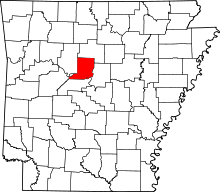
Menifee High School Gymnasium |
|
000000002002-06-06-0000June 6, 2002
(#02000601) |
Junction of N. Park St. and E. Mustang St.
35°08′50″N 92°32′48″W / 35.147222°N 92.546667°W / 35.147222; -92.546667 (Menifee High School Gymnasium) |
Menifee |
|
| 18 |
Moose Addition Neighborhood Historic District |
|
000000002013-09-13-0000September 13, 2013
(#13000349) |
Roughly bounded by W. Valley, S. Moose, Green, Brown & S. Division Sts.; also Roughly bounded by S. St. Joseph, E. Green, S. Chestnut, E. Valley, S. Morrill & E. Church Sts.
35°08′59″N 92°44′49″W / 35.1497°N 92.7470°W / 35.1497; -92.7470 (Moose Addition Neighborhood Historic District) |
Morrilton |
Second set of addresses represents a boundary increase May 26, 2015.
|
| 19 |
Moose House |
|
000000001974-10-22-0000October 22, 1974
(#74000472) |
711 Green St.
35°08′56″N 92°44′15″W / 35.148889°N 92.7375°W / 35.148889; -92.7375 (Moose House) |
Morrilton |
|
| 20 |
Morrilton Commercial Historic District |
|
000000002003-03-07-0000March 7, 2003
(#03000085) |
Roughly bounded by E. Railroad, Broadway, N. Division, and N. Moose Sts.
35°09′13″N 92°44′39″W / 35.153611°N 92.744167°W / 35.153611; -92.744167 (Morrilton Commercial Historic District) |
Morrilton |
|
| 21 |
Morrilton Post Office |
|
000000001998-08-14-0000August 14, 1998
(#98000921) |
117 N. Division St.
35°09′14″N 92°44′42″W / 35.153889°N 92.745°W / 35.153889; -92.745 (Morrilton Post Office) |
Morrilton |
|
| 22 |
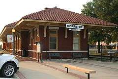
Morrilton Railroad Station |
|
000000001977-09-13-0000September 13, 1977
(#77000249) |
Railroad Ave. between Division and Moose Sts.
35°08′55″N 92°44′40″W / 35.148611°N 92.744444°W / 35.148611; -92.744444 (Morrilton Railroad Station) |
Morrilton |
|
| 23 |
Old US 64, Menifee Segment |
|
000000002006-03-02-0000March 2, 2006
(#06000071) |
Canal Rd., approximately 0.5 miles southeast of U.S. Route 64
35°08′52″N 92°33′16″W / 35.147778°N 92.554444°W / 35.147778; -92.554444 (Old US 64, Menifee Segment) |
Menifee |
|
| 24 |
Petit Jean No. 4 |
Upload image |
000000001982-05-04-0000May 4, 1982
(#82002105) |
Address Restricted
|
Oppelo |
|
| 25 |
Petit Jean No. 5 |
Upload image |
000000001982-05-04-0000May 4, 1982
(#82002106) |
Address Restricted
|
Oppelo |
|
| 26 |
Petit Jean No. 6 |
Upload image |
000000001982-05-04-0000May 4, 1982
(#82002107) |
Address Restricted
|
Oppelo |
|
| 27 |
Petit Jean No. 7 |
Upload image |
000000001982-05-04-0000May 4, 1982
(#82002108) |
Address Restricted
|
Oppelo |
|
| 28 |
Petit Jean No. 9 |
Upload image |
000000001982-05-04-0000May 4, 1982
(#82002109) |
Address Restricted
|
Oppelo |
|
| 29 |
Petit Jean No. 10 |
Upload image |
000000001982-05-04-0000May 4, 1982
(#82002103) |
Address Restricted
|
Oppelo |
|
| 30 |
Petit Jean No. 11 |
Upload image |
000000001982-05-04-0000May 4, 1982
(#82002104) |
Address Restricted
|
Oppelo |
|
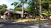
| 31 |
Petit Jean State Park-Administration Office |
|
000000001992-05-28-0000May 28, 1992
(#92000520) |
Highway 154 east of Bench Mark 914 in Petit Jean State Park
35°07′39″N 92°55′09″W / 35.1275°N 92.919167°W / 35.1275; -92.919167 (Petit Jean State Park-Administration Office) |
Winrock |
|
| 32 |
Petit Jean State Park-Blue Hole Road District |
|
000000001992-05-28-0000May 28, 1992
(#92000513) |
Blue Hole Rd. in Petit Jean State Park
35°07′17″N 92°57′16″W / 35.121389°N 92.954444°W / 35.121389; -92.954444 (Petit Jean State Park-Blue Hole Road District) |
Winrock |
|
| 33 |
Petit Jean State Park-Cabin No. 1 |
|
000000001992-05-28-0000May 28, 1992
(#92000523) |
Campground access road in Petit Jean State Park
35°07′05″N 92°56′13″W / 35.118056°N 92.936944°W / 35.118056; -92.936944 (Petit Jean State Park-Cabin No. 1) |
Winrock |
|
| 34 |
Petit Jean State Park-Cabin No. 6 |
|
000000001992-05-28-0000May 28, 1992
(#92000524) |
Campground access road in Petit Jean State Park
35°07′07″N 92°56′15″W / 35.118611°N 92.9375°W / 35.118611; -92.9375 (Petit Jean State Park-Cabin No. 6) |
Winrock |
|
| 35 |
Petit Jean State Park-Cabin No. 9 |
|
000000001992-05-28-0000May 28, 1992
(#92000525) |
Campground access road in Petit Jean State Park
35°07′08″N 92°56′20″W / 35.118889°N 92.938889°W / 35.118889; -92.938889 (Petit Jean State Park-Cabin No. 9) |
Winrock |
|
| 36 |
Petit Jean State Park-Cabin No. 16 |
|
000000001992-05-28-0000May 28, 1992
(#92000522) |
Campground access road in Petit Jean State Park
35°07′07″N 92°56′21″W / 35.118611°N 92.939167°W / 35.118611; -92.939167 (Petit Jean State Park-Cabin No. 16) |
Winrock |
|
| 37 |
Petit Jean State Park-Cedar Falls Trail Historic District |
|
000000001992-05-28-0000May 28, 1992
(#92000514) |
Adjacent to the main access road in Petit Jean State Park
35°07′01″N 92°56′30″W / 35.116944°N 92.941667°W / 35.116944; -92.941667 (Petit Jean State Park-Cedar Falls Trail Historic District) |
Winrock |
|
| 38 |
Petit Jean State Park-Concrete Log Bridge |
|
000000001992-05-28-0000May 28, 1992
(#92000519) |
Highway 154 south of Bench Mark 914 in Petit Jean State Park
35°07′34″N 92°55′29″W / 35.126111°N 92.924722°W / 35.126111; -92.924722 (Petit Jean State Park-Concrete Log Bridge) |
Winrock |
|
| 39 |
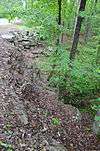
Petit Jean State Park-Culvert No. 1 |
|
000000001992-05-28-0000May 28, 1992
(#92000518) |
Highway 154 in Petit Jean State Park
35°07′05″N 92°55′58″W / 35.118056°N 92.932778°W / 35.118056; -92.932778 (Petit Jean State Park-Culvert No. 1) |
Winrock |
|
| 40 |
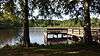
Petit Jean State Park-Lake Bailey-Roosevelt Lake Historic District |
|
000000001992-05-28-0000May 28, 1992
(#92000515) |
East and north of Highway 154 in Petit Jean State Park
35°07′45″N 92°54′54″W / 35.129167°N 92.915°W / 35.129167; -92.915 (Petit Jean State Park-Lake Bailey-Roosevelt Lake Historic District) |
Winrock |
|
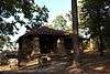
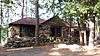
| 41 |
Petit Jean State Park-Mather Lodge |
|
000000001992-05-28-0000May 28, 1992
(#92000521) |
Main access road in Petit Jean State Park
35°07′02″N 92°56′18″W / 35.117222°N 92.938333°W / 35.117222; -92.938333 (Petit Jean State Park-Mather Lodge) |
Petit Jean State Park |
|
| 42 |
Petit Jean State Park-Office Headquarters |
|
000000001992-05-28-0000May 28, 1992
(#92000516) |
Highway 154, approximately 500 feet south of Bench Mark 914 in Petit Jean State Park
35°07′35″N 92°55′34″W / 35.126389°N 92.926111°W / 35.126389; -92.926111 (Petit Jean State Park-Office Headquarters) |
Winrock |
|
| 43 |
Petit Jean State Park-Water Treatment Building |
|
000000001992-05-28-0000May 28, 1992
(#92000517) |
On a dirt access road south of its junction with Highway 154, approximately 800 feet east of Bench Mark 914 in Petit Jean State Park
35°07′31″N 92°55′20″W / 35.125278°N 92.922222°W / 35.125278; -92.922222 (Petit Jean State Park-Water Treatment Building) |
Winrock |
|
| 44 |
Plumerville School Building |
Upload image |
000000001992-09-10-0000September 10, 1992
(#92001193) |
Arnold St.
35°09′30″N 92°38′03″W / 35.158333°N 92.634167°W / 35.158333; -92.634167 (Plumerville School Building) |
Plumerville |
|
| 45 |
Plummer's Station |
|
000000001975-08-11-0000August 11, 1975
(#75000378) |
South of Plumerville on Gap Creek
35°09′21″N 92°38′33″W / 35.155833°N 92.6425°W / 35.155833; -92.6425 (Plummer's Station) |
Plumerville |
|
| 46 |
Rockhouse Cave, Petit Jean No. 2 |
|
000000001982-05-04-0000May 4, 1982
(#82002110) |
Address Restricted
|
Oppelo |
|
| 47 |
Saint Anthony's Hospital |
|
000000001986-03-28-0000March 28, 1986
(#86000581) |
202 E. Green St.
35°08′51″N 92°44′37″W / 35.1475°N 92.743611°W / 35.1475; -92.743611 (Saint Anthony's Hospital) |
Morrilton |
|
| 48 |
Seven Hollows-Petit Jean Mountain Site #1 |
Upload image |
000000002006-09-20-0000September 20, 2006
(#06000833) |
Southeast of the junction of Highways 154 and 155 in Petit Jean State Park[7]
35°06′37″N 92°56′53″W / 35.110278°N 92.948056°W / 35.110278; -92.948056 (Seven Hollows-Petit Jean Mountain Site #1) |
Winrock |
|
| 49 |
Sims Hotel |
Upload image |
000000001975-08-28-0000August 28, 1975
(#75000379) |
Center of Plumerville
35°09′29″N 92°38′33″W / 35.158056°N 92.6425°W / 35.158056; -92.6425 (Sims Hotel) |
Plumerville |
|
| 50 |
Trinity Lutheran Church |
|
000000001976-12-13-0000December 13, 1976
(#76000396) |
7.2 miles south of Atkins off Highway 154
35°07′58″N 92°55′31″W / 35.132778°N 92.925278°W / 35.132778; -92.925278 (Trinity Lutheran Church) |
Atkins |
|
| 51 |
Union Chapel School and Shop Building |
|
000000002016-01-26-0000January 26, 2016
(#15000993) |
298 Union Chapel Rd. & 28 Acker Ln.
35°13′55″N 92°33′21″W / 35.232003°N 92.555929°W / 35.232003; -92.555929 (Union Chapel School and Shop Building) |
Springfield vicinity |
|
| 52 |
West Church Street Historic District |
|
000000002015-05-25-0000May 25, 2015
(#15000259) |
Roughly bounded by S. Morrill, Valley, S. Cherokee & W. Church Sts.
35°09′04″N 92°44′54″W / 35.1511°N 92.7482°W / 35.1511; -92.7482 (West Church Street Historic District) |
Morrilton |
|
| 53 |
W.L. Wood House |
|
000000002002-06-06-0000June 6, 2002
(#02000604) |
709 N. Morrill St.
35°09′40″N 92°44′46″W / 35.161111°N 92.746111°W / 35.161111; -92.746111 (W.L. Wood House) |
Morrilton |
|