Ohio State Route 56
| ||||
|---|---|---|---|---|
 | ||||
| Route information | ||||
| Maintained by ODOT | ||||
| Length: | 108.80 mi[1] (175.10 km) | |||
| Existed: | 1923 – present | |||
| Major junctions | ||||
| West end: |
| |||
|
| ||||
| East end: |
| |||
| Location | ||||
| Counties: | Champaign, Clark, Madison, Pickaway, Hocking, Vinton, Athens | |||
| Highway system | ||||
| ||||

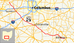
State Route 56 (SR 56) is a west–east state highway in central Ohio. Its western terminus is at SR 29 near Mutual, and its eastern terminus is at SR 682 in Athens.
Route description
SR 56 travels in a generally northwest-southwest direction in an arc around the southwestern side of Columbus.[2] As of 2012, no part of SR 56 is included within the National Highway System.[3]
History
The route of SR 56 between Mutual and Laurelville has been included within the state highway system since 1912.[4] In 1923, the many numbered routes were unified as SR 56 running along the route it continues to run today.[5][6] By 1926, the route was extended east from its end in Laurelville to Athens running along the same route it has currently.[7][8]
Major junctions
| County | Location | mi[1] | km | Destinations | Notes | |||
|---|---|---|---|---|---|---|---|---|
| Champaign | Union Township | 0.00 | 0.00 | |||||
| 2.14 | 3.44 | |||||||
| Clark |
No major junctions | |||||||
| Madison | Somerford Township | 11.47 | 18.46 | Southern terminus of SR 187 | ||||
| 12.39 | 19.94 | Exit 72 (I-70) | ||||||
| 13.20 | 21.24 | |||||||
| London | 17.17 | 27.63 | Western end of SR 38 / SR 665 concurrency; western terminus of SR 142 | |||||
| 17.48 | 28.13 | Eastern end of SR 38 / SR 665 concurrency | ||||||
| Pleasant Township | 29.48 | 47.44 | Exit 84 (I-71) | |||||
| 32.14 | 51.72 | Eastern terminus of SR 323 | ||||||
| Mount Sterling | 32.92 | 52.98 | Western end of SR 207 concurrency | |||||
| 32.99 | 53.09 | Eastern end of SR 207 concurrency | ||||||
| Pickaway | Monroe Township | 38.65 | 62.20 | Western terminus of SR 316 | ||||
| Jackson Township | 49.22 | 79.21 | ||||||
| Wayne Township | 51.20 | 82.40 | Western end of US 22 concurrency | |||||
| Circleville | 52.37 | 84.28 | Interchange | |||||
| 52.76 | 84.91 | Western terminus of SR 188 | ||||||
| 53.41 | 85.96 | Eastern end of US 22 concurrency | ||||||
| Salt Creek Township | 60.28 | 97.01 | ||||||
| 67.19 | 108.13 | Western end of SR 180 concurrency | ||||||
| Hocking | Laurelville | 67.84 | 109.18 | Eastern end of SR 180 concurrency | ||||
| Benton Township | 77.23 | 124.29 | Southern terminus of SR 664 | |||||
| 81.39 | 130.98 | Southern terminus of SR 374 | ||||||
| Vinton | Swan Township | 85.95 | 138.32 | |||||
| Brown Township | 89.60 | 144.20 | Western end of SR 328 concurrency | |||||
| Hocking | Starr Township | 92.15 | 148.30 | Eastern end of SR 328 concurrency | ||||
| 96.25 | 154.90 | Western end of SR 278 concurrency | ||||||
| 96.34 | 155.04 | Eastern end of SR 278 concurrency | ||||||
| Vinton |
No major junctions | |||||||
| Athens | Waterloo Township | 100.61 | 161.92 | Northern terminus of SR 356 | ||||
| 101.79 | 163.82 | Southern terminus of SR 691 | ||||||
| Athens | 108.80 | 175.10 | ||||||
1.000 mi = 1.609 km; 1.000 km = 0.621 mi
| ||||||||
References
- 1 2 Ohio Department of Transportation. "Technical Services Straight Line Diagrams". Retrieved January 18, 2014.
- ↑ Google (January 18, 2014). "Ohio State Route 56" (Map). Google Maps. Google. Retrieved January 18, 2014.
- ↑ National Highway System: Ohio (PDF) (Map). Federal Highway Administration. October 2012. Retrieved January 18, 2014.
- ↑ Map of Ohio Showing Inter-County Highways (MrSID) (Map). Cartography by James R. Marker, State Highway Commissioner. Ohio State Highway Department. 1912. Retrieved August 18, 2013.
- ↑ Map of Ohio State Highways Showing All Improved Roadways (MrSID) (Map). Cartography by E.C. Blosser. Ohio Department of Highways and Public Works. 1922. Retrieved August 18, 2013.
- ↑ Map of Ohio Showing State Routes (MrSID) (Map). Cartography by L.A. Boulay, Director. ODOH. 1923. Retrieved August 18, 2013.
- ↑ Map of Ohio Showing State Routes (MrSID) (Map). Cartography by G.F. Schlesinger, Director. ODOH. 1925. Retrieved August 18, 2013.
- ↑ Map of Ohio Showing State Routes (MrSID) (Map). Cartography by G.F. Schlesinger, Director. ODOH. 1926. Retrieved September 22, 2013.
