Ohio State Route 9
| |||||||
|---|---|---|---|---|---|---|---|
|
Route of SR 9 highlighted in red | |||||||
| Route information | |||||||
| Maintained by ODOT | |||||||
| Length: | 92.51 mi[1][2][3][4] (148.88 km) | ||||||
| Existed: | 1935 – present | ||||||
| Major junctions | |||||||
| South end: |
| ||||||
|
| |||||||
| North end: |
| ||||||
| Location | |||||||
| Counties: | Belmont, Harrison, Carroll, Columbiana | ||||||
| Highway system | |||||||
| |||||||

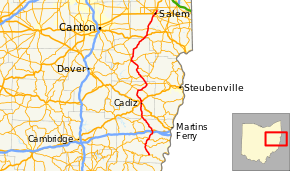
State Route 9 (SR 9) is a north–south route running through four counties in east central Ohio. Its route is 92.5 miles (148.9 km) long. The southern terminus is at SR 148 in Armstrongs Mills and the northern terminus is with US 62 north of Salem.
Route description
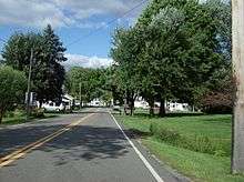
Northbound along State Route 9, approaching U.S. Route 30 in Kensington
History
- before 1931 – Route 9 ran from Cincinnati to Michigan.[5] This highway followed the current U.S. Highway 127 from the Ohio River at Cincinnati to just south of Bryan and followed current Ohio State Route 15 northward to the Michigan state line.
- 1935 – New incarnation of route 9 certified;[6] Originally routed from Malaga to Salem along current routes 145, 148, and 9.[5]
- 1938 – Southern end truncated to Armstrongs Mills.[5]
- 1974 – Northern end extended through Salem to 2 miles (3.2 km) north of Salem.[5]
Major intersections
| County | Location | mi[1][2][3][4] | km | Destinations | Notes |
|---|---|---|---|---|---|
| Belmont | Washington Township | 0.00 | 0.00 | Southern terminus | |
| Smith Township | 5.94 | 9.56 | Southern end of SR 147 concurrency | ||
| 6.71 | 10.80 | Northern end of SR 147 concurrency | |||
| 10.38 | 16.70 | Southern end of SR 149 concurrency | |||
| 10.51 | 16.91 | Northern end of SR 149 concurrency | |||
| Richland Township | 14.53– 14.58 | 23.38– 23.46 | Diamond interchange; exit 216 on I-70 | ||
| St. Clairsville | 15.39 | 24.77 | |||
| Harrison | Athens Township | 24.70 | 39.75 | Northern terminus of SR 149 | |
| New Athens | 25.24 | 40.62 | |||
| Cadiz | 31.90 | 51.34 | Southern end of US 250 concurrency | ||
| 32.72– 32.90 | 52.66– 52.95 | Northern end of US 250 concurrency; Partial cloverleaf interchange | |||
| Rumley Township | 39.94 | 64.28 | Southern end of SR 151 concurrency | ||
| Jewett | 41.77 | 67.22 | Northern end of SR 151 concurrency | ||
| German Township | 46.07 | 74.14 | Southern end of SR 646 concurrency | ||
| 46.66 | 75.09 | Northern end of SR 646 concurrency | |||
| Carroll | Loudon Township | 51.13 | 82.29 | Southern end of SR 164 concurrency | |
| 51.19 | 82.38 | Northern end of SR 164 concurrency | |||
| Lee Township | 56.40 | 90.77 | Southern end of SR 43 concurrency | ||
| Center Township | 61.28 | 98.62 | Southern end of SR 39 concurrency | ||
| Carrollton | 61.79 | 99.44 | Northern end of SR 39/43 concurrences; Northern terminus of SR 332 | ||
| Washington Township | 65.47 | 105.36 | |||
| Columbiana | Hanover Township | 76.76 | 123.53 | Southern end of US 30 concurrency; Northern terminus of SR 644 | |
| Hanoverton | 78.30 | 126.01 | Northern end of US 30 concurrency | ||
| Hanover Township | 81.51 | 131.18 | |||
| Perry Township | 88.81 | 142.93 | |||
| Salem | 90.47 | 145.60 | Southern end of SR 14 concurrency | ||
| 90.73 | 146.02 | Northern end of SR 14 concurrency | |||
| 92.51 | 148.88 | Northern terminus at a T-intersection | |||
1.000 mi = 1.609 km; 1.000 km = 0.621 mi
| |||||
References
- 1 2 Ohio Department of Transportation. "Technical Services DESTAPE - Belmont County" (PDF). Retrieved 2013-11-26.
- 1 2 Ohio Department of Transportation. "Technical Services DESTAPE - Harrison County" (PDF). Retrieved 2013-11-26.
- 1 2 Ohio Department of Transportation. "Technical Services DESTAPE - Carroll County" (PDF). Retrieved 2013-11-26.
- 1 2 Ohio Department of Transportation. "Technical Services DESTAPE - Columbiana County" (PDF). Retrieved 2013-11-26.
- 1 2 3 4 Route 9 (The Unofficial Ohio State Highways Web Site) by John Simpson Archived December 14, 2004, at the Wayback Machine.
- ↑ Explanation of the Ohio State Highway System (The Unofficial Ohio State Highways Web Site) by John Simpson Archived July 23, 2008, at the Wayback Machine.
External links
This article is issued from Wikipedia - version of the 11/17/2016. The text is available under the Creative Commons Attribution/Share Alike but additional terms may apply for the media files.