Oakwood, Queensland
| Oakwood Queensland | |||||||||||||
|---|---|---|---|---|---|---|---|---|---|---|---|---|---|
 Oakwood | |||||||||||||
| Coordinates | 24°51′10″S 152°17′30″E / 24.85278°S 152.29167°ECoordinates: 24°51′10″S 152°17′30″E / 24.85278°S 152.29167°E | ||||||||||||
| Population | 341 (2011 census)[1] | ||||||||||||
| Postcode(s) | 4670 | ||||||||||||
| Elevation | 21.6 m (71 ft) | ||||||||||||
| Location | |||||||||||||
| LGA(s) | Bundaberg Region | ||||||||||||
| State electorate(s) | Burnett | ||||||||||||
| Federal Division(s) | Flynn | ||||||||||||
| |||||||||||||
| |||||||||||||
Oakwood is a locality in the Bundaberg Region of the greater Wide Bay region of Queensland, Australia.[2] It is about 300 km from Queensland's capital city of Brisbane and Bundaberg is about 5.89 km away. Oakwood is in the federal electorate of Flynn. In the 2011 census the population of Oakwood was 341.[3]
Geography
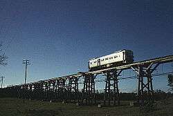
Oakwood is bounded on the south by the Burnett River and on the west by Splitters Creek. The North Coast railway line forms its north-eastern border. Camp Island (24°51′53″S 152°17′56″E / 24.8648°S 152.2989°E) in the Burnett River is within the locality's borders. There is a network of sugar cane tramways through the locality.[4]
Climate
Oakwood has a subtropical climate with wet, hot summers and mild winters. The annual rainfall of Oakwood is about 1010 mm.The most rain received by Oakwood in a day was 258 mm. The most rain received by Oakwood in a September day was around 125 mm.[3]
History
Oakwood State School opened on 24 March 1924 under head teacher James Whalley.[5][6]
Heritage listings
Oakwood has the following heritage listings:
Community
Oakwood has several notable places where the community can get together and relax and entertain themselves. The Oakwood Community Church is a non-denominational church on the main road and it sits opposite a park from the Oakwood Queensland Country Women's Association Hall. The Oakwood State School also serves as a place where the local families gather.[8]
Sport
- Oakwood Park Golf Club
- Burnett Wide Bay Regional Appaloosa Club Inc: the club holds its meetings in the Oakwood QCWA Hall.
Tourism
- Oakwood Caravan Park, provides accommodation with caravan berths and cabins for rent.
- SSS Strawberries is a large strawberry farm that has a strawberry shop and has put forward plans to build the Giant Strawberry which will act as a shop, cafe, education tour and offices.[9] This would be Bundaberg's second large object, there is already a Big Bundy Bottle outside of the Bundaberg Rum distillery.
See also
References
- ↑ Australian Bureau of Statistics (31 October 2012). "Oakwood (Qld) (State Suburb)". 2011 Census QuickStats. Retrieved 29 September 2015.
- ↑ "Oakwood (entry 48371)". Queensland Place Names. Queensland Government. Retrieved 30 September 2015.
- 1 2 "Frequently asked questions about Oakwood, QLD". bonzle.com.
- ↑ "Queensland Globe". State of Queensland. Retrieved 30 September 2015.
- ↑ "Opening and closing dates of Queensland Schools". Queensland Government. Retrieved 30 September 2015.
- ↑ "Agency ID5596, Oakwood State School". Queensland State Archives. Retrieved 30 September 2015.
- ↑ "Splitters Creek Railway Bridge (entry 600529)". Queensland Heritage Register. Queensland Heritage Council. Retrieved 7 July 2013.
- ↑ "Our school". eq.edu.au.
- ↑ "Contact us - SSS Strawberries". sss-strawberries.com.au.
External links
![]() Media related to Oakwood, Queensland at Wikimedia Commons
Media related to Oakwood, Queensland at Wikimedia Commons