Northern Rockies Regional Municipality
| Northern Rockies | |
|---|---|
| District municipality[1] | |
| Northern Rockies Regional Municipality[2] | |
 | |
| Country | Canada |
| Province | British Columbia |
| District municipality[1] | February 6, 2009 |
| Government | |
| • Type | District municipality |
| • Mayor | Bill Streeper |
| • Councillors |
List
|
| Area (2011)[3] | |
| • Total | 85,014.52 km2 (32,824.29 sq mi) |
| Population (2011)[4] | |
| • Total | 5,290 |
| • Density | 0.062/km2 (0.16/sq mi) |
| Time zone | Mountain[5] (UTC-7) |
| • Summer (DST) | not observed (UTC-7) |
| Area code(s) | 250 |
| Website | northernrockies.ca |
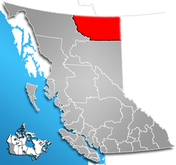
The Northern Rockies Regional Municipality (NRRM), formerly the Northern Rockies Regional District (NRRD), and before that the Fort Nelson-Liard Regional District, is a municipality in northeastern British Columbia, Canada. Although portrayed as a regional municipality in its official name, it is actually classified as a district municipality.[1] The NRRM’s offices are located in Fort Nelson, formerly an incorporated town that amalgamated with the NRRD on February 6, 2009 to form the NRRM.[6][7] With the Peace River Regional District as the southern part, it was the northern part of the Peace River-Liard Regional District, which was split into two on October 31, 1987.
The NRRM lies on the east slope of the Rocky Mountains, and comprises approximately 10% of the total area of the province of British Columbia, encompassing 85,014.52 square kilometres (32,824.29 sq mi).[3] Its southern boundary is the 58th parallel of latitude[8] and is bisected by the Alaska Highway from its southeast to its northwest. The Northern Rockies Regional Municipality is primarily made up of heavily forested areas and mountainous terrain.
The Northern Rockies Regional Municipality is the first of its kind in British Columbia in which an entire former regional district is governed and headed by a single municipal government. Its council comprises a mayor and six councillors. Bill Streeper has been the NRRM's mayor since it was formed.
Communities
Fort Nelson
With a 2011 population of 3,902,[9] Fort Nelson is the largest community in the Northern Rockies Regional Municipality. All of the NRRM's offices and officials are based out of Fort Nelson.
Fort Nelson First Nation
Fort Nelson First Nation is an aboriginal band situated directly outside of the town of Fort Nelson and a signatory nation of Treaty 8. The reserve is home to about 700 residents, making Fort Nelson First Nation one of the largest reservations in northern British Columbia. Dene and Cree are the most prevalent Aboriginal Canadian backgrounds found on the Fort Nelson First Nation reserve. The nation works closely with oil and gas producers to ensure safe and sustainable development in the Horn River Basin based on the fact that much of the new development in the Horn River Basin is occurring on traditional Fort Nelson First Nation land. The band operates Echo-Dene and the Liard Hot Springs lodge, as well as Chalo School, a kindergarten to grade twelve accredited educational institution. Liz Logan is the Chief Councilor of the Fort Nelson First Nation, reelected in August 2014. The FNFN Band Council consists of seven councilors, an increase from six. The chosen councilors then decided amongst themselves the Chief Councilor.[10] [11]
Prophet River First Nation
The Prophet River First Nation is the southernmost community in the Northern Rockies Regional Municipality. Prophet River’s main industries revolve around commercial services and provisions to the local and nearby oil and gas industry. Lynette Tsakoza is currently the chief of Prophet River First Nation which is a member of the Treaty 8 Tribal Association.[12]
Tetsa River
Tetsa River is a small community based on the Alaska Highway that is known for its eco-tourism and camping. Fishing, rafting, hunting, and other eco-tourism related activities are commonly practiced recreational attractants to the region. Tetsa River offers a popular fishing derby every August, in which residents from all over the region compete.
Toad River
Toad River is the largest regional community north of Fort Nelson in terms of population. The community is home to a highway maintenance camp, a small school accredited by the region's school district (School District 81), a community hall, two campgrounds, and two lodges. Toad River’s economy relies primarily on tourism, and is a popular destination for travellers on the Alaska Highway.
Muncho Lake
Muncho Lake is a community that is situated on the Muncho Lake Provincial Park. The park is known for its blue-coloured lake which attracts tourists to the area every year. Muncho Lake is situated on the Alaska Highway.
Demographics
In the 2011 Census, Statistics Canada originally reported that the Northern Rockies Regional Municipality had a population of 4,987 living in 1,985 of its 2,271 total dwellings, a -12.5% change from its 2006 population of 5,702.[3] Statistics Canada subsequently amended the 2011 census results to a population of 5,290 living in 2,090 of its 2,317 total dwellings, a -7.2% change from 2006.[4] With a land area of 85,014.52 km2 (32,824.29 sq mi), it had a population density of 0.1/km2 (0.2/sq mi) in 2011.[3][4] Prior to the census, the estimated 2011 population of the NRRM was 6,324.[13]
- 1 2 3 "Order of the Lieutenant Governor in Council (Order in Council No. 033)" (PDF). Province of British Columbia. January 29, 2009. p. 3. Retrieved September 20, 2014.
The class of the municipality is a district municipality.
- ↑ "British Columbia Regional Districts, Municipalities, Corporate Name, Date of Incorporation and Postal Address" (XLS). British Columbia Ministry of Communities, Sport and Cultural Development. Retrieved November 2, 2014.
- 1 2 3 4 "Population and dwelling counts, for Canada, provinces and territories, and census subdivisions (municipalities), 2011 and 2006 censuses (British Columbia)". Statistics Canada. January 30, 2013. Retrieved June 15, 2013.
- 1 2 3 "Corrections and updates". Statistics Canada. March 21, 2013. Retrieved June 15, 2013.
- ↑ New Time Zone in Fort Nelson, timeanddate.com, 21 September 2015.
- ↑ "Fort Nelson". Northern Rockies Regional Municipality. Retrieved December 6, 2012.
- ↑ "Statistics Relating to Regional and Municipal Governments in BC 2011" (PDF). British Columbia Ministry of Community, Sport and Cultural Development. p. 21 of 30. Retrieved December 6, 2012.
- ↑ "Northern Rockies Regional Municipality". BC Geographical Names.
- ↑ "Census Profile - Fort Nelson, Town, British Columbia (Dissolved census subdivision) and Northern Rockies, RD, British Columbia (Census division)". Statistics Canada. November 2, 2012. Retrieved December 6, 2012.
- ↑ "Fort Nelson First Nation". Fort Nelson First Nation. Retrieved 19 June 2012.
- ↑ http://www.fortnelsonfirstnation.org
- ↑ "Treaty 8". Treaty 8 Tribal Association. Retrieved 19 June 2012.
- ↑ "2011 Sub-Provincial Population Estimates" (PDF). BC Stats. January 2012. Retrieved December 6, 2012.
External links
| Wikimedia Commons has media related to Northern Rockies Regional Municipality. |
- Northern Rockies Regional District & Town of Fort Nelson
- Northern BC Tourism
- 2001 Census Profile - Northern Rockies Regional District
- "Northern Rockies Regional District (rescinded)". BC Geographical Names.
- Fort Nelson First Nation
| Subdivisions |  | |
|---|---|---|
| Communities | ||
| Metro areas and agglomerations | ||
| Regional districts |
| |
| ||
Coordinates: 59°00′00″N 123°45′00″W / 59.00000°N 123.75000°W
