North Carolina Highway 162
| ||||
|---|---|---|---|---|
 | ||||
| Route information | ||||
| Maintained by NCDOT | ||||
| Length: | 7.5 mi[1] (12.1 km) | |||
| Existed: | 2007 – present | |||
| Major junctions | ||||
| West end: |
| |||
| East end: |
| |||
| Location | ||||
| Counties: | Cumberland | |||
| Highway system | ||||
| ||||

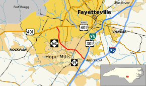
North Carolina Highway 162 (NC 162) is a primary state highway in the U.S. state of North Carolina. The highway serves as an alternate route to NC 59 by bypassing downtown Hope Mills.
Route description
NC 162 is a short road at only 7.5 miles (12.1 km) in length. It is intended to be a bypass for NC 59. The road begins at U.S. Route 401 (US 401) near the Lafayette Shopping Center. After crossing NC 59, it bypasses Hope Mills to its north, ending at Interstate 95 Business (I-95 Bus.) and US 301.[1]
History
The first NC 162 was established in 1937 as a renumbering of NC 161. It traversed from NC 16 in Warrensville, to Rugby Road at the Virginia state line. In 1953, the entire route was renumbered as part of NC 194.
The second and current NC 162 was established in 2007 as a new primary routing that was signed on George Owen Road between Fisher Road and Camden Road, crossing NC 59. In 2009, it was extended to its current western terminus with US 401 (Raeford Road) via Bingham Drive and Bunce Road. In 2011, it was extended east from Camden Road to Legion Road. In 2013, after widening and other improvements on Elk Road, NC 162 was extended west along Elk Road to its current terminus with I-95 Bus/US 301, completing the Hope Mills bypass.[2][3][4]
Major junctions
The entire highway is in Cumberland County.
| Location | mi[1] | km | Destinations | Notes | |
|---|---|---|---|---|---|
| Fayetteville | 0.0 | 0.0 | |||
| Hope Mills | 3.7 | 6.0 | |||
| 7.5 | 12.1 | ||||
| 1.000 mi = 1.609 km; 1.000 km = 0.621 mi | |||||
References
- 1 2 3 Google (November 23, 2013). "North Carolina Highway 163" (Map). Google Maps. Google. Retrieved November 23, 2013.
- ↑ "NC Route Changes (2009-02-11)" (PDF). North Carolina Department of Transportation. February 11, 2009. Retrieved November 23, 2013.
- ↑ "NC Route Changes (2011-10-04)" (PDF). North Carolina Department of Transportation. October 4, 2011. Retrieved November 23, 2013.
- ↑ "NC Route Changes (2013-03-28)" (PDF). North Carolina Department of Transportation. March 28, 2013. Retrieved November 23, 2013.
External links
-
 Media related to North Carolina Highway 162 at Wikimedia Commons
 - NCRoads.com: N.C. 162