New Shady Grove, Arkansas
| New Shady Grove, Arkansas | |
|---|---|
| Unincorporated community | |
 New Shady Grove, Arkansas  New Shady Grove, Arkansas | |
| Coordinates: 35°07′55″N 90°26′41″W / 35.13194°N 90.44472°WCoordinates: 35°07′55″N 90°26′41″W / 35.13194°N 90.44472°W | |
| Country | United States |
| State | Arkansas |
| County | St. Francis |
| Elevation | 207 ft (63 m) |
| Time zone | Central (CST) (UTC-6) |
| • Summer (DST) | CDT (UTC-5) |
| Area code(s) | 870 |
| GNIS feature ID | 82965[1] |
New Shady Grove is an unincorporated community in St. Francis County, Arkansas, United States. New Shady Grove is located on U.S. Route 70, 3.3 miles (5.3 km) southwest of Jennette.
References
Municipalities and communities of St. Francis County, Arkansas, United States | ||
|---|---|---|
| Cities | 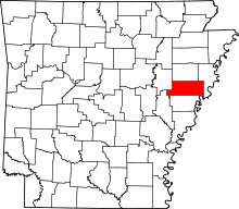 | |
| Towns | ||
| Unincorporated communities | ||
| Footnotes | ‡This populated place also has portions in an adjacent county or counties | |
This article is issued from Wikipedia - version of the 7/29/2016. The text is available under the Creative Commons Attribution/Share Alike but additional terms may apply for the media files.