| [4] |
Name on the Register[5] |
Image |
Date listed[6] |
Location |
Village |
Description |
|---|
| 1 |
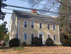
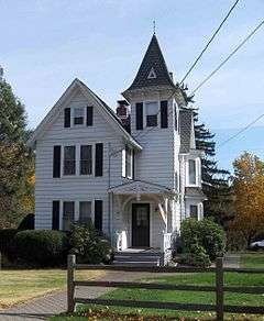
Luman Andrews House |
|
000000001989-01-19-0000January 19, 1989
(#88003095) |
469 Andrews St.
41°37′23″N 72°49′52″W / 41.623056°N 72.831111°W / 41.623056; -72.831111 (Luman Andrews House) |
|
Colonial house built in 1745; property is also important as location where volcanic rock suited for Portland cement was discovered.[7]*
|
| 2 |
Atwater Manufacturing Company |
Upload image |
000000001988-12-08-0000December 8, 1988
(#88002678) |
335 Atwater St.
41°34′43″N 72°53′54″W / 41.578611°N 72.898333°W / 41.578611; -72.898333 (Atwater Manufacturing Company) |
Plantsville[8] |
|
| 3 |
Selah Barnes House |
Upload image |
000000001989-01-19-0000January 19, 1989
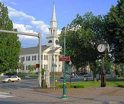
(#88003114) |
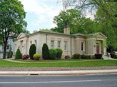
282 Prospect St.
41°35′29″N 72°54′01″W / 41.591389°N 72.900278°W / 41.591389; -72.900278 (Selah Barnes House) |
Plantsville[9] |
|
| 4 |
Barnes-Frost House |
|
000000001989-01-19-0000January 19, 1989
(#88003109) |
1177 Marion Ave.
41°33′56″N 72°55′31″W / 41.565556°N 72.925278°W / 41.565556; -72.925278 (Barnes-Frost House) |
Marion[10] |
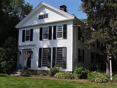
Built in 1795, significant in part as it is a preserved example of Colonial architecture, and also because it was home of the Barnes and Frost families.[11] The house shows a "high-style Federal embellishment", namely a "diamond and ellipse frieze band pattern".[12]:6*
|
| 5 |
Blakeslee Forging Company |
Upload image |
000000001988-12-08-0000December 8, 1988
(#88002676) |
100 W. Main St.
41°34′38″N 72°53′36″W / 41.577222°N 72.893333°W / 41.577222; -72.893333 (Blakeslee Forging Company) |
Plantsville[13] |
|
| 6 |
Icabod Bradley House |
Upload image |
000000001989-07-28-0000July 28, 1989
(#88003115) |
537 Shuttle Meadow Rd.
41°38′55″N 72°50′40″W / 41.648611°N 72.844444°W / 41.648611; -72.844444 (Icabod Bradley House) |
|
|
| 7 |
Clark Brothers Factory No. 1 |
Upload image |
000000001988-12-08-0000December 8, 1988
(#88002679) |
1331 S. Main St.
41°34′03″N 72°54′10″W / 41.5675°N 72.902778°W / 41.5675; -72.902778 (Clark Brothers Factory No. 1) |
Milldale[14] |
|
| 8 |
Clark Brothers Factory No. 2 |
Upload image |
000000001988-12-08-0000December 8, 1988
(#88002680) |
409 Canal St.
41°34′15″N 72°53′46″W / 41.570833°N 72.896111°W / 41.570833; -72.896111 (Clark Brothers Factory No. 2) |
Milldale[15] |
|
| 9 |
Avery Clark House |
Upload image |
000000001989-01-19-0000January 19, 1989
(#88003110) |
1460 Meriden Ave.
41°33′48″N 72°51′12″W / 41.563333°N 72.853333°W / 41.563333; -72.853333 (Avery Clark House) |
|
|
| 10 |
Capt. Josiah Cowles House |
|
000000001989-01-19-0000January 19, 1989
(#88003102) |
184 Marion Ave.
41°35′05″N 72°54′12″W / 41.584722°N 72.903333°W / 41.584722; -72.903333 (Capt. Josiah Cowles House) |
Plantsville[16] |
Residence, c. 1750,[16] of an early settler, who was born in Farmington, Connecticut on November 20, 1713.[17] Cowles was a justice of the peace and a captain in the local militia. He held a number of town offices, and was viewed as a leading man in town.[17] At the very first town meeting after the incorporation of Southington, held November 11, 1779, the residents appointed Cowles, along with Jonathan Root to a committee to "provide for the families of officers and soldiers in the field."[18]:378 In 1774, Cowles was appointed to a committee to deliver provisions to Boston, in response to the British blockade of Boston harbor.[18]:180
|
| 11 |
Ebenezer Evans House |
Upload image |
000000001989-01-19-0000January 19, 1989
(#88003101) |
17 Long Bottom Rd.
41°37′50″N 72°50′03″W / 41.630556°N 72.834167°W / 41.630556; -72.834167 (Ebenezer Evans House) |
|
|
| 12 |
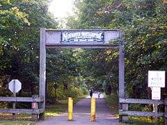
Farmington Canal-New Haven and Northampton Canal |
|
000000001985-09-12-0000September 12, 1985
(#85002664) |
Roughly from Suffield in Hartford County to New Haven in New Haven County
41°36′00″N 72°53′00″W / 41.599917°N 72.883472°W / 41.599917; -72.883472 (Farmington Canal-New Haven and Northampton Canal) |
|
First a canal, later a railroad, and now a multi-use trail.
|
| 13 |
Levi B. Frost House |
|
000000001987-11-20-0000November 20, 1987
(#87002037) |
1089 Marion Ave.
41°34′05″N 72°55′29″W / 41.568056°N 72.924722°W / 41.568056; -72.924722 (Levi B. Frost House) |
Marion[19] |
Also known as the Asa Barnes Tavern.
|
| 14 |
Stephen Grannis House |
Upload image |
000000001989-01-19-0000January 19, 1989
(#88003119) |
1193 West St.
41°37′14″N 72°53′58″W / 41.620556°N 72.899444°W / 41.620556; -72.899444 (Stephen Grannis House) |
|
|
| 15 |
Timothy Hart House |
Upload image |
000000001989-01-19-0000January 19, 1989
(#88003100) |
521 Flanders Rd.
41°37′09″N 72°50′43″W / 41.619167°N 72.845278°W / 41.619167; -72.845278 (Timothy Hart House) |
|
|
| 16 |
House at 1010 Shuttle Meadow Road |
Upload image |
000000001989-01-19-0000January 19, 1989
(#88003116) |
1010 Shuttle Meadow Rd.
41°38′58″N 72°51′12″W / 41.649444°N 72.853333°W / 41.649444; -72.853333 (House at 1010 Shuttle Meadow Road) |
|
|
| 17 |
House at 590 West Street |
Upload image |
000000001989-01-19-0000January 19, 1989
(#88003118) |
590 West St.
41°36′16″N 72°53′57″W / 41.604444°N 72.899167°W / 41.604444; -72.899167 (House at 590 West Street) |
|
|
| 18 |
Hubbard Park |
|
000000001997-12-15-0000December 15, 1997
(#97001466) |
Roughly bounded by W. Main St., Interstate 691, CT 66, Reservoir Ave., Edgewood Dr.
41°33′45″N 72°50′05″W / 41.5625°N 72.834722°W / 41.5625; -72.834722 (Hubbard Park) |
|
A park partly in in Southington, Meriden, and Berlin.
|
| 19 |
Hurwood Company |
Upload image |
000000001988-12-08-0000December 8, 1988
(#88002681) |
379 Summer St.
41°35′22″N 72°53′26″W / 41.589444°N 72.890556°W / 41.589444; -72.890556 (Hurwood Company) |
Plantsville[20] |
|
| 20 |
Lake Compounce Carousel |
Upload image |
000000001978-12-12-0000December 12, 1978
(#78002865) |
West of Southington Center on Lake Ave.
41°38′21″N 72°55′22″W / 41.639167°N 72.922778°W / 41.639167; -72.922778 (Lake Compounce Carousel) |
|
|
| 21 |
Marion Historic District |
|
000000001988-12-21-0000December 21, 1988
(#88001423) |
Along Marion Ave. and Meriden-Waterbury Turnpike, in town of Southington and in town of Cheshire (in New Haven County)
41°33′50″N 72°55′29″W / 41.563889°N 72.924722°W / 41.563889; -72.924722 (Marion Historic District) |
|
|
| 22 |
Meriden Avenue-Oakland Road Historic District |
|
000000001988-05-25-0000May 25, 1988
(#88000580) |
Roughly Oakland Rd. between Meriden and Berlin Aves., and Meriden Ave. between Oakland Rd. and Delhunty Dr.
41°35′31″N 72°52′26″W / 41.591944°N 72.873889°W / 41.591944; -72.873889 (Meriden Avenue-Oakland Road Historic District) |
|
|
| 23 |
Roswell Moore II House |
Upload image |
000000002005-07-01-0000July 1, 2005
(#88003093) |
1166 Andrews St.
41°36′18″N 72°49′44″W / 41.605°N 72.828889°W / 41.605; -72.828889 (Roswell Moore II House) |
|
|
| 24 |
Peck, Stow & Wilcox Factory |
Upload image |
000000001988-12-08-0000December 8, 1988
(#88002682) |
217 Center St.
41°36′08″N 72°52′59″W / 41.602222°N 72.883056°W / 41.602222; -72.883056 (Peck, Stow & Wilcox Factory) |
|
|
| 25 |
Plantsville Historic District |
|
000000001988-12-01-0000December 1, 1988
(#88002673) |
Roughly bounded by Prospect St., Summer St., the Quinnipiac River, Grove St., S. Main St., W. Main St., and West St.
41°35′26″N 72°53′35″W / 41.590556°N 72.893056°W / 41.590556; -72.893056 (Plantsville Historic District) |
|
|
| 26 |
Dr. J. Porter House |
Upload image |
000000001989-01-19-0000January 19, 1989
(#88003096) |
391 Belleview Ave.
41°35′05″N 72°52′07″W / 41.584722°N 72.868611°W / 41.584722; -72.868611 (Dr. J. Porter House) |
|
|
| 27 |
Pultz & Walkley Company |
Upload image |
000000001988-12-08-0000December 8, 1988
(#88002677) |
120 W. Main St.
41°35′12″N 72°53′34″W / 41.586667°N 72.892778°W / 41.586667; -72.892778 (Pultz & Walkley Company) |
Plantsville[21] |
|
| 28 |
Jonathan Root House |
|
000000001989-01-19-0000January 19, 1989
(#88003113) |
140-142 N. Main St.
41°36′16″N 72°52′43″W / 41.604444°N 72.878611°W / 41.604444; -72.878611 (Jonathan Root House) |
|
|
| 29 |
Dr. Henry Skelton House |
Upload image |
000000001989-01-19-0000January 19, 1989
(#88003117) |
889 S. Main St.
41°35′02″N 72°53′32″W / 41.583889°N 72.892222°W / 41.583889; -72.892222 (Dr. Henry Skelton House) |
|
|
| 30 |
H. D. Smith Company Building |
|
000000001977-09-19-0000September 19, 1977
(#77001420) |
24 West St.
41°35′19″N 72°53′56″W / 41.588611°N 72.898889°W / 41.588611; -72.898889 (H. D. Smith Company Building) |
Plantsville[22] |
|
| 31 |
Southington Center Historic District |
|
000000001989-05-08-0000May 8, 1989
(#88002961) |
Roughly N. Main St. north from Vermont Ave., and Berlin St. from Main St. to Academy Ln.
41°36′12″N 72°52′41″W / 41.603333°N 72.878056°W / 41.603333; -72.878056 (Southington Center Historic District) |
|
|
| 32 |
Southington Public Library |
|
000000001989-02-09-0000February 9, 1989
(#89000015) |
239 Main St. in Southington Center
41°35′48″N 72°52′41″W / 41.596667°N 72.878056°W / 41.596667; -72.878056 (Southington Public Library) |
|
Building now houses the local historical society.
|
| 33 |
Horace Webster Farmhouse |
Upload image |
000000001977-08-24-0000August 24, 1977
(#77001417) |
577 South End Rd.
41°34′01″N 72°52′27″W / 41.566944°N 72.874167°W / 41.566944; -72.874167 (Horace Webster Farmhouse) |
Plantsville[23] |
|
| 34 |
West Street School |
Upload image |
000000001988-12-01-0000December 1, 1988
(#88002689) |
1432 West St.
41°37′39″N 72°54′03″W / 41.6275°N 72.900833°W / 41.6275; -72.900833 (West Street School) |
|
|
| 35 |
Rev. John Wightman House |
Upload image |
000000001989-01-19-0000January 19, 1989
(#88003111) |
1024 Mount Vernon Rd.
41°35′56″N 72°55′32″W / 41.598889°N 72.925556°W / 41.598889; -72.925556 (Rev. John Wightman House) |
|
|
| 36 |
Valentine Wightman House |
Upload image |
000000001989-01-19-0000January 19, 1989
(#88003112) |
1112 Mount Vernon Rd.
41°36′04″N 72°55′32″W / 41.601111°N 72.925556°W / 41.601111; -72.925556 (Valentine Wightman House) |
|
|
| 37 |
Woodruff House |
Upload image |
000000001989-01-19-0000January 19, 1989
(#88003097) |
377 Berlin St.
41°35′49″N 72°51′21″W / 41.596944°N 72.855833°W / 41.596944; -72.855833 (Woodruff House) |
|
|
| 38 |
Capt. Samuel Woodruff House |
Upload image |
000000001989-05-05-0000May 5, 1989
(#89000014) |
23 Old State Rd.
41°35′52″N 72°50′51″W / 41.597778°N 72.8475°W / 41.597778; -72.8475 (Capt. Samuel Woodruff House) |
|
|
| 39 |
Ezekiel Woodruff House |
Upload image |
000000001989-01-19-0000January 19, 1989
(#88003099) |
1152 East St.
41°35′41″N 72°50′32″W / 41.594722°N 72.842222°W / 41.594722; -72.842222 (Ezekiel Woodruff House) |
|
|
| 40 |
Jotham Woodruff House |
Upload image |
000000001989-01-19-0000January 19, 1989
(#88003120) |
137-139 Woodruff St.
41°36′07″N 72°52′13″W / 41.601944°N 72.870278°W / 41.601944; -72.870278 (Jotham Woodruff House) |
|
|
| 41 |
Urbana Woodruff House |
Upload image |
000000001989-01-19-0000January 19, 1989
(#88003098) |
1096 East St.
41°35′37″N 72°50′31″W / 41.593611°N 72.841944°W / 41.593611; -72.841944 (Urbana Woodruff House) |
|
|