National Register of Historic Places listings in Ottawa County, Oklahoma
Location of Ottawa County in Oklahoma
This is a list of the National Register of Historic Places listings in Ottawa County, Oklahoma.
This is intended to be a complete list of the properties and districts on the National Register of Historic Places in Ottawa County, Oklahoma, United States. The locations of National Register properties and districts for which the latitude and longitude coordinates are included below, may be seen in a map.[1]
There are 17 properties and districts listed on the National Register in the county.
- This National Park Service list is complete through NPS recent listings posted December 2, 2016.[2]
- Adair
- Alfalfa
- Atoka
- Beaver
- Beckham
- Blaine
- Bryan
- Caddo
- Canadian
- Carter
- Cherokee
- Choctaw
- Cimarron
- Cleveland
- Coal
- Comanche
- Cotton
- Craig
- Creek
- Custer
- Delaware
- Dewey
- Ellis
- Garfield
- Garvin
- Grady
- Grant
- Greer
- Harmon
- Harper
- Haskell
- Hughes
- Jackson
- Jefferson
- Johnston
- Kay
- Kingfisher
- Kiowa
- Latimer
- Le Flore
- Lincoln
- Logan
- Love
- Major
- Marshall
- Mayes
- McClain
- McCurtain
- McIntosh
- Murray
- Muskogee
- Noble
- Nowata
- Okfuskee
- Oklahoma
- Okmulgee
- Osage
- Ottawa
- Pawnee
- Payne
- Pittsburg
- Pontotoc
- Pottawatomie
- Pushmataha
- Roger Mills
- Rogers
- Seminole
- Sequoyah
- Stephens
- Texas
- Tillman
- Tulsa
- Wagoner
- Washington
- Washita
- Woods
- Woodward
Current listings
| [3] | Name on the Register[4] | Image | Date listed[5] | Location | City or town | Description |
|---|---|---|---|---|---|---|
| 1 | Cities Service Station | Upload image | (#95000039) |
Junction of 1st St. and Central Ave. 36°41′33″N 94°57′56″W / 36.69255°N 94.9656°W |
Afton | |
| 2 | Coleman Theatre |  |
(#83002114) |
1st and Main Sts. 36°52′34″N 94°52′39″W / 36.876111°N 94.8775°W |
Miami | |
| 3 | George L. Coleman Sr. House |  |
(#83002113) |
1001 Rockdale St. 36°53′00″N 94°51′40″W / 36.883333°N 94.861111°W |
Miami | |
| 4 | Commerce Building/Hancock Building |  |
(#83002115) |
103 E. Central 36°52′28″N 94°52′35″W / 36.874444°N 94.876389°W |
Miami | |
| 5 | Dobson Family House | 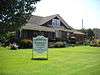 |
(#11000340) |
106 A St., SW 36°52′24″N 94°52′43″W / 36.873333°N 94.878611°W |
Miami | |
| 6 | Horse Creek Bridge | 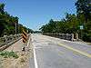 |
(#95000040) |
Junction of the former U.S. Route 66 and Horse Creek 36°41′49″N 94°57′23″W / 36.696944°N 94.956389°W |
Afton | |
| 7 | John Patrick McNaughton Barn |  |
(#91001903) |
Ottawa County Road 137, 1.5 miles north of State Highway 10 36°53′53″N 94°47′07″W / 36.898056°N 94.785278°W |
Quapaw | |
| 8 | Miami Downtown Historic District | |
(#09000357) |
Roughly the 100 block of N. Main St., the 0 block of S. Main St., the 0 blocks of E. and W. Central Ave., and the 0 block of SE. A St. 36°52′29″N 94°52′39″W / 36.874722°N 94.8775°W |
Miami | |
| 9 | Miami Marathon Oil Company Service Station |  |
(#95000041) |
331 S. Main St. 36°52′11″N 94°52′37″W / 36.869722°N 94.876944°W |
Miami | |
| 10 | Miami Original Nine-Foot Section of Route 66 Roadbed | 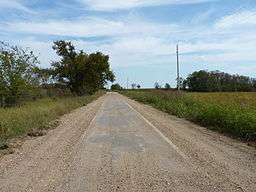 |
(#94001610) |
From the junction of E St., SW. and 130th St. to the former U.S. Route 66 36°49′22″N 94°54′31″W / 36.822778°N 94.908611°W |
Miami | |
| 11 | Modoc Mission Church and Cemetery | 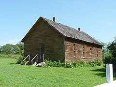 |
(#80003293) |
Southeast of Miami 36°51′53″N 94°39′43″W / 36.864722°N 94.661944°W |
Miami | |
| 12 | Narcissa D-X Gas Station | Upload image | (#03001240) |
15050 S. State Highway 69 36°48′03″N 94°55′36″W / 36.800833°N 94.926667°W |
Miami | |
| 13 | Ottawa County Courthouse | Upload image | (#04000122) |
102 East Central 36°52′27″N 94°52′33″W / 36.874167°N 94.875833°W |
Miami | Note: Demolished in 2008 |
| 14 | Peoria Indian School | 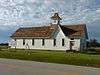 |
(#83002116) |
East of Miami 36°54′52″N 94°44′31″W / 36.914444°N 94.741944°W |
Miami | |
| 15 | Peoria Tribal Cemetery | 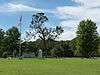 |
(#83002117) |
East of Miami 36°54′01″N 94°45′39″W / 36.900278°N 94.760833°W |
Miami | |
| 16 | Riviera Courts-Motel | 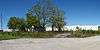 |
(#04000524) |
1 mile west of Main on U.S. Route 69A 36°51′56″N 94°54′01″W / 36.865556°N 94.900278°W |
Miami | |
| 17 | Tri-State Zinc and Lead Ore Producers Association Office | 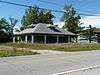 |
(#03000097) |
508 N. Connell Ave. 36°59′28″N 94°49′52″W / 36.991111°N 94.831111°W |
Picher |
See also
| Wikimedia Commons has media related to National Register of Historic Places in Ottawa County, Oklahoma. |
- List of National Historic Landmarks in Oklahoma
- National Register of Historic Places listings in Oklahoma
References
- ↑ The latitude and longitude information provided in this table was derived originally from the National Register Information System, which has been found to be fairly accurate for about 99% of listings. For about 1% of NRIS original coordinates, experience has shown that one or both coordinates are typos or otherwise extremely far off; some corrections may have been made. A more subtle problem causes many locations to be off by up to 150 yards, depending on location in the country: most NRIS coordinates were derived from tracing out latitude and longitudes off of USGS topographical quadrant maps created under the North American Datum of 1927, which differs from the current, highly accurate WGS84 GPS system used by most on-line maps. Chicago is about right, but NRIS longitudes in Washington are higher by about 4.5 seconds, and are lower by about 2.0 seconds in Maine. Latitudes differ by about 1.0 second in Florida. Some locations in this table may have been corrected to current GPS standards.
- ↑ "National Register of Historic Places: Weekly List Actions". National Park Service, United States Department of the Interior. Retrieved on December 2, 2016.
- ↑ Numbers represent an ordering by significant words. Various colorings, defined here, differentiate National Historic Landmarks and historic districts from other NRHP buildings, structures, sites or objects.
- ↑ National Park Service (2009-03-13). "National Register Information System". National Register of Historic Places. National Park Service.
- ↑ The eight-digit number below each date is the number assigned to each location in the National Register Information System database, which can be viewed by clicking the number.
| Topics | |
|---|---|
| Lists by states |
|
| Lists by insular areas | |
| Lists by associated states | |
| Other areas | |
| |
Municipalities and communities of Ottawa County, Oklahoma, United States | ||
|---|---|---|
| Cities | | |
| Towns | ||
| CDPs | ||
| Unincorporated communities | ||
| Ghost towns | ||
This article is issued from Wikipedia - version of the 5/15/2016. The text is available under the Creative Commons Attribution/Share Alike but additional terms may apply for the media files.