National Register of Historic Places listings in Colfax County, Nebraska

Location of Colfax County in Nebraska
This is a list of the National Register of Historic Places listings in Colfax County, Nebraska.
This is intended to be a complete list of the properties and districts on the National Register of Historic Places in Colfax County, Nebraska, United States. The locations of National Register properties and districts for which the latitude and longitude coordinates are included below, may be seen in a map.[1]
There are 12 properties and districts listed on the National Register in the county.
- This National Park Service list is complete through NPS recent listings posted December 16, 2016.[2]
Current listings
| [3] | Name on the Register | Image | Date listed[4] | Location | City or town | Description |
|---|---|---|---|---|---|---|
| 1 | Colfax County Courthouse | _from_NE_1.JPG) |
(#81000369) |
Off Nebraska Highway 15 41°26′49″N 97°03′18″W / 41.446944°N 97.055°W |
Schuyler | |
| 2 | John Janecek House | 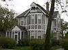 |
(#82003185) |
805 E. 8th St. 41°26′38″N 97°03′04″W / 41.443889°N 97.051111°W |
Schuyler | |
| 3 | Oak Ballroom | 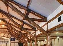 |
(#83001082) |
Colfax St. 41°26′15″N 97°03′39″W / 41.4375°N 97.060833°W |
Schuyler | |
| 4 | Our Lady of Perpetual Help Catholic Church & Cemetery | _from_NE.jpg) |
(#82000600) |
Southern side of Road N, 9 miles north and 5.5 miles west of Schuyler[5] 41°34′51″N 97°09′42″W / 41.580750°N 97.161750°W |
Schuyler | |
| 5 | Schuyler Carnegie Library | 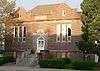 |
(#01001275) |
1003 B St. 41°26′48″N 97°03′26″W / 41.446667°N 97.057222°W |
Schuyler | |
| 6 | Schuyler City Hall | 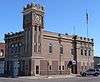 |
(#81000370) |
1020 A St. 41°26′50″N 97°03′29″W / 41.447222°N 97.058056°W |
Schuyler | |
| 7 | Schuyler Downtown Historic District | Upload image | (#16000478) |
Railside Dr., Colfax, 12th, C, D & 10th Sts. 41°26′50″N 97°03′27″W / 41.447329°N 97.057457°W |
Schuyler | |
| 8 | Schuyler Site | Upload image | (#73001057) |
Address Restricted |
Schuyler | |
| 9 | US Post Office-Schuyler | |
(#92000476) |
119 E. 11th St. 41°26′50″N 97°03′32″W / 41.447117°N 97.058834°W |
Schuyler | One of 12 Nebraska post offices featuring a Section of Fine Arts mural, "Wild Horses by Moonlight" (1940) by Philip von Saltza.[6] |
| 10 | Wolfe Archeological Site | Upload image | (#74001105) |
Address Restricted |
Schuyler | |
| 11 | Z.C.B.J. Opera House | 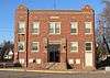 |
(#88000948) |
Fourth and Pine 41°43′26″N 97°07′21″W / 41.723889°N 97.1225°W |
Clarkson | |
| 12 | Zion Presbyterian Church | _from_SW_1.JPG) |
(#87002071) |
5 miles southeast of Clarkson off Nebraska Highway 15 41°41′04″N 97°03′33″W / 41.684444°N 97.059167°W |
Clarkson |
See also
- List of National Historic Landmarks in Nebraska
- National Register of Historic Places listings in Nebraska
References
- ↑ The latitude and longitude information provided in this table was derived originally from the National Register Information System, which has been found to be fairly accurate for about 99% of listings. For about 1% of NRIS original coordinates, experience has shown that one or both coordinates are typos or otherwise extremely far off; some corrections may have been made. A more subtle problem causes many locations to be off by up to 150 yards, depending on location in the country: most NRIS coordinates were derived from tracing out latitude and longitudes off of USGS topographical quadrant maps created under the North American Datum of 1927, which differs from the current, highly accurate WGS84 GPS system used by most on-line maps. Chicago is about right, but NRIS longitudes in Washington are higher by about 4.5 seconds, and are lower by about 2.0 seconds in Maine. Latitudes differ by about 1.0 second in Florida. Some locations in this table may have been corrected to current GPS standards.
- ↑ "National Register of Historic Places: Weekly List Actions". National Park Service, United States Department of the Interior. Retrieved on December 16, 2016.
- ↑ Numbers represent an ordering by significant words. Various colorings, defined here, differentiate National Historic Landmarks and historic districts from other NRHP buildings, structures, sites or objects.
- ↑ The eight-digit number below each date is the number assigned to each location in the National Register Information System database, which can be viewed by clicking the number.
- ↑ Location derived from its NRHP nomination form; the NRIS lists the site as "Address Restricted"
- ↑ Ahlgren, Carol (August 1991). "National Register of Historic Places Multiple Property Documentation Form: Nebraska Post Offices Which Contain Section Artwork (1938-1942)" (PDF). Retrieved 2013-01-28.
External links
| Wikimedia Commons has media related to National Register of Historic Places in Colfax County, Nebraska. |
- Nebraska National Register Sites in Colfax County–Nebraska State Historical Society
| Topics | |
|---|---|
| Lists by states |
|
| Lists by insular areas | |
| Lists by associated states | |
| Other areas | |
| |
Municipalities and communities of Colfax County, Nebraska, United States | ||
|---|---|---|
| Cities | ||
| Villages | ||
| Unincorporated communities | ||
This article is issued from Wikipedia - version of the 10/18/2016. The text is available under the Creative Commons Attribution/Share Alike but additional terms may apply for the media files.