Muncie, Kansas
| Muncie | |
|---|---|
| Neighborhood | |
 Muncie Location within the state of Kansas | |
| Coordinates: 39°5′15″N 94°44′50″W / 39.08750°N 94.74722°WCoordinates: 39°5′15″N 94°44′50″W / 39.08750°N 94.74722°W | |
| Country | United States |
| State | Kansas |
| County | Wyandotte |
| Time zone | Central (CST) (UTC-6) |
| • Summer (DST) | CDT (UTC-5) |
Muncie is a neighborhood in Kansas City, Kansas on the north bank of the Kansas River. Rail lines run through it.
The area[1] derives its name from the Munsee (tribe) which was part of the Algonquian speaking Delaware (tribe). Reverend Jesse Vogler[2] and John Kilbuck, and 72 Christianized Munsee Indians, came to the area aboard the St. Peters. The Munsee Moravian Mission was located in the Westfield settlement.[3]
On December 8, 1874, the James-Younger Gang are believed to have robbed a Kansas Pacific Railroad there of $30,000.
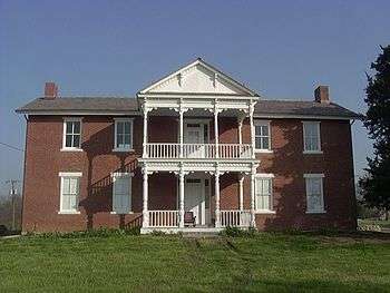
Grinter Place in the Grinter Heights neighborhood is on the National Register of Historic Places. A ferry that was used on the military route between Fort Leavenworth, Kansas and Fort Scott, Kansas crossed the river here.
References and citations
- ↑ eight miles above the Kaw's mouth, and north of the river
- ↑ Moravian (United Brethren) missionary
- ↑ Kansas Historical Quarterly - Kansas Before 1854, A Revised Annals, Part Nine - Kansas Historical Society