Mountains of East Kerry
| Mangerton Mountains | |
|---|---|
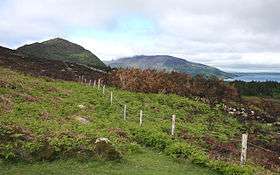 Moorland on the lower slopes of Mangerton Mountain | |
| Highest point | |
| Peak | Mangerton Mountain |
| Elevation | 839 m (2,753 ft) |
| Geography | |
| Country | Republic of Ireland |
| Provinces of Ireland | Munster |
The Mountains of East Kerry, also called the Mangerton Mountains,[1] are a range of mountains situated immediately to the south and east of Killarney National Park and the town of Killarney in County Kerry in Ireland. The mountain range is unnamed, but forms a natural unit, being separated from the other mountain ranges in the area by the Lakes of Killarney to the north-west, the valley of the river Flesk to the north and east, the Kenmare valley to the south and is linked to the mountains of the Iveragh Peninsula only by a relatively low ridge at Moll's Gap at its western end. A substantial part of the western end of the range has been incorporated into Killarney National Park and is a popular area for hikes and hillwalking.
Topography
For the most part, the east Kerry mountains form a relatively low, flat, boggy plateau that stretches for approximately 20 km from east to west, with a few taller peaks scattered across the range. Some of the more notable peaks include: Derrygarriff, 492 m; Peakeen Mountain, 555 m; Knockanaguish, 509 m; Knockrower, 554 m; Torc Mountain, 535 m; Mangerton Mountain, 839 m; Stoompa, 705 m; and Crohane (Cruachán), 650 m. Despite most of the area consisting of a bog-covered plateau, some dramatic features created by the last ice age can be seen: Glenacappul, or the Horse's Glen, is a deep U-shaped valley just to the east of Mangerton; the Devil's Punchbowl is a corrie lake below Mangerton's summit to the west; and Lough Guitane is a large lake created when meltwater filled a depression in the ground created by a glacier.
See also
References
