Monterey, Louisiana
| Monterey, Louisiana | |
|---|---|
| Census-designated place | |
 Monterey Location within Louisiana | |
| Coordinates: 31°26′33″N 91°43′12″W / 31.44250°N 91.72000°WCoordinates: 31°26′33″N 91°43′12″W / 31.44250°N 91.72000°W | |
| Country |
|
| State |
|
| Parish | Concordia |
| Area | |
| • Total | 8.1 km2 (3.1 sq mi) |
| • Land | 7.3 km2 (2.8 sq mi) |
| • Water | 0.8 km2 (0.3 sq mi) |
| Elevation | 17 m (55 ft) |
| Population (2010) | 439 |
| • Density | 59.8/km2 (155/sq mi) |
| Time zone | CST (UTC-6) |
| • Summer (DST) | CST (UTC-5) |
| ZIP Codes | 71354 |
| Area Code | 318 |
Monterey is an unincorporated community and census-designated place (CDP) in Concordia Parish, Louisiana, United States. As of the 2010 census it had a population of 439.[1]
The community is located near the junction of Louisiana Highways 129 and 565 in west central Concordia Parish, southwest of Ferriday.[2] It is also part of the Natchez, MS–LA Micropolitan Statistical Area.
Although it is unincorporated, Monterey has a post office, with the ZIP code of 71354.[3] Public education in the community is provided by Concordia Parish Schools
Notable people
- Eugene P. Campbell (1870–1940), longest-serving sheriff of Concordia Parish
- Noah W. Cross (1908–1976), Concordia Parish sheriff convicted of perjury
- Shelby M. Jackson (1903–1972), Louisiana superintendent of education, 1948 to 1964
References
- ↑ "Geographic Identifiers: 2010 Demographic Profile Data (G001): Monterey CDP, Louisiana". U.S. Census Bureau, American Factfinder. Retrieved August 21, 2014.
- ↑ "Place Names". Concord Parish, LAGenWeb. Retrieved 2010-01-09.
- ↑ Zip Code Lookup
Municipalities and communities of Concordia Parish, Louisiana, United States | ||
|---|---|---|
| Cities | 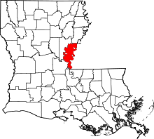 | |
| Towns | ||
| CDPs | ||
| Other unincorporated communities |
| |
This article is issued from Wikipedia - version of the 9/8/2015. The text is available under the Creative Commons Attribution/Share Alike but additional terms may apply for the media files.