Monteleone di Fermo
| Monteleone di Fermo | |
|---|---|
| Comune | |
| Comune di Monteleone di Fermo | |
 Monteleone di Fermo Location of Monteleone di Fermo in Italy | |
| Coordinates: 43°3′N 13°32′E / 43.050°N 13.533°ECoordinates: 43°3′N 13°32′E / 43.050°N 13.533°E | |
| Country | Italy |
| Region | Marche |
| Province / Metropolitan city | Province of Fermo (FM) |
| Area | |
| • Total | 8.1 km2 (3.1 sq mi) |
| Population (Dec. 2004) | |
| • Total | 449 |
| • Density | 55/km2 (140/sq mi) |
| Time zone | CET (UTC+1) |
| • Summer (DST) | CEST (UTC+2) |
| Postal code | 63020 |
| Dialing code | 0734 |
Monteleone di Fermo is a comune (municipality) in the Province of Fermo in the Italian region Marche, located about 70 kilometres (43 mi) south of Ancona, about 35 kilometres (22 mi) north of Ascoli Piceno and 25 kilometres (16 mi) of Fermo. As of 31 December 2004, it had a population of 449 and an area of 8.1 square kilometres (3.1 sq mi).[1]
Monteleone di Fermo borders the following municipalities: Belmonte Piceno, Monsampietro Morico, Montelparo, Santa Vittoria in Matenano, Servigliano.
Among the churches in the town are the following:
- San Marone Martire.
- San Giovanni Battista, Monteleone di Fermo.
- Madonna di Loreto.
- Madonna della Misericordia.
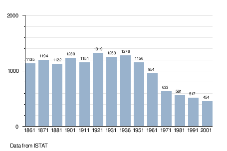
Demographic evolution
References
This article is issued from Wikipedia - version of the 5/21/2016. The text is available under the Creative Commons Attribution/Share Alike but additional terms may apply for the media files.
