Marengo, Ohio
| Marengo, Ohio | |
|---|---|
| Village | |
|
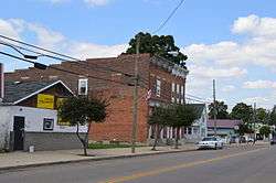
Main Street downtown | |
 Location of Marengo, Ohio | |
 Location of Marengo in Morrow County | |
| Coordinates: 40°24′5″N 82°48′37″W / 40.40139°N 82.81028°WCoordinates: 40°24′5″N 82°48′37″W / 40.40139°N 82.81028°W | |
| Country | United States |
| State | Ohio |
| County | Morrow |
| Area[1] | |
| • Total | 0.17 sq mi (0.44 km2) |
| • Land | 0.17 sq mi (0.44 km2) |
| • Water | 0 sq mi (0 km2) |
| Elevation[2] | 1,158 ft (353 m) |
| Population (2010)[3] | |
| • Total | 342 |
| • Estimate (2012[4]) | 344 |
| • Density | 2,011.8/sq mi (776.8/km2) |
| Time zone | Eastern (EST) (UTC-5) |
| • Summer (DST) | EDT (UTC-4) |
| ZIP code | 43334 |
| Area code(s) | 419 |
| FIPS code | 39-47558[5] |
| GNIS feature ID | 1042984[2] |
Marengo is a village in Morrow County, Ohio, United States. The population was 342 at the 2010 census. Marengo is south of Mount Gilead, the county seat.
History
Marengo was platted in 1873, although there had been permanent settlement at the site since the 1840s.[6] A post office called Marengo was established in 1848.[7]
Geography
Marengo is located at 40°24′5″N 82°48′37″W / 40.40139°N 82.81028°W (40.401341, -82.810382).[8] It is considered to be a part of "Central Ohio".
According to the United States Census Bureau, the village has a total area of 0.17 square miles (0.44 km2), all of it land.[1]
Demographics
| Historical population | |||
|---|---|---|---|
| Census | Pop. | %± | |
| 1880 | 91 | — | |
| 1890 | 276 | 203.3% | |
| 1900 | 242 | −12.3% | |
| 1910 | 283 | 16.9% | |
| 1920 | 267 | −5.7% | |
| 1930 | 225 | −15.7% | |
| 1940 | 275 | 22.2% | |
| 1950 | 275 | 0.0% | |
| 1960 | 321 | 16.7% | |
| 1970 | 330 | 2.8% | |
| 1980 | 329 | −0.3% | |
| 1990 | 393 | 19.5% | |
| 2000 | 297 | −24.4% | |
| 2010 | 342 | 15.2% | |
| Est. 2015 | 346 | [9] | 1.2% |
2010 census
As of the census[3] of 2010, there were 342 people, 133 households, and 92 families residing in the village. The population density was 2,011.8 inhabitants per square mile (776.8/km2). There were 148 housing units at an average density of 870.6 per square mile (336.1/km2). The racial makeup of the village was 95.3% White, 1.2% from other races, and 3.5% from two or more races. Hispanic or Latino of any race were 1.5% of the population.
There were 133 households of which 42.9% had children under the age of 18 living with them, 40.6% were married couples living together, 19.5% had a female householder with no husband present, 9.0% had a male householder with no wife present, and 30.8% were non-families. 25.6% of all households were made up of individuals and 12.8% had someone living alone who was 65 years of age or older. The average household size was 2.57 and the average family size was 3.08.
The median age in the village was 31.8 years. 31% of residents were under the age of 18; 8.4% were between the ages of 18 and 24; 27.1% were from 25 to 44; 22.9% were from 45 to 64; and 10.5% were 65 years of age or older. The gender makeup of the village was 48.0% male and 52.0% female.
2000 census
As of the census[5] of 2000, there were 297 people, 114 households, and 80 families residing in the village. The population density was 1,668.8 people per square mile (637.1/km²). There were 120 housing units at an average density of 674.3 per square mile (257.4/km²). The racial makeup of the village was 95.96% White, 0.34% Asian, 0.34% from other races, and 3.37% from two or more races. Hispanic or Latino of any race were 0.67% of the population.
There were 114 households out of which 41.2% had children under the age of 18 living with them, 48.2% were married couples living together, 11.4% had a female householder with no husband present, and 29.8% were non-families. 21.9% of all households were made up of individuals and 5.3% had someone living alone who was 65 years of age or older. The average household size was 2.61 and the average family size was 3.05.
In the village the population was spread out with 29.6% under the age of 18, 10.8% from 18 to 24, 31.3% from 25 to 44, 19.9% from 45 to 64, and 8.4% who were 65 years of age or older. The median age was 31 years. For every 100 females there were 95.4 males. For every 100 females age 18 and over, there were 97.2 males.
The median income for a household in the village was $35,625, and the median income for a family was $47,000. Males had a median income of $33,125 versus $21,528 for females. The per capita income for the village was $14,768. About 3.5% of families and 9.2% of the population were below the poverty line, including 6.3% of those under the age of eighteen and none of those sixty five or over.
References
- 1 2 "US Gazetteer files 2010". United States Census Bureau. Retrieved 2013-01-06.
- 1 2 "US Board on Geographic Names". United States Geological Survey. 2007-10-25. Retrieved 2008-01-31.
- 1 2 "American FactFinder". United States Census Bureau. Retrieved 2013-01-06.
- ↑ "Population Estimates". United States Census Bureau. Retrieved 2013-06-17.
- 1 2 "American FactFinder". United States Census Bureau. Retrieved 2008-01-31.
- ↑ Baughman, Abraham J.; Bartlett, Robert Franklin (1911). History of Morrow County, Ohio: A Narrative Account of Its Historical Progress, Its People, and Its Principal Interests. Lewis Publishing Company. p. 380.
- ↑ "Morrow County". Jim Forte Postal History. Retrieved 15 December 2015.
- ↑ "US Gazetteer files: 2010, 2000, and 1990". United States Census Bureau. 2011-02-12. Retrieved 2011-04-23.
- ↑ "Annual Estimates of the Resident Population for Incorporated Places: April 1, 2010 to July 1, 2015". Retrieved July 2, 2016.
- ↑ "Census of Population and Housing". Census.gov. Retrieved June 4, 2015.
Municipalities and communities of Morrow County, Ohio, United States | ||
|---|---|---|
| City |  | |
| Villages | ||
| Townships | ||
| CDPs | ||
| Unincorporated communities | ||
| Ghost towns | ||
| Footnotes | ‡This populated place also has portions in an adjacent county or counties | |