List of lighthouses in the Isle of Man
This is a list of lighthouses in the Isle of Man which is located in the Irish Sea between England and Ireland.[1]
Lighthouses
| Lighthouse | Image | Location coordinates |
Year built | Tower height | Focal height | Range | Notes |
|---|---|---|---|---|---|---|---|
| Calf of Man (low) |  | Calf of Man 54°03.157′N 4°49.734′W / 54.052617°N 4.828900°W | 1815 | 15 m (49 ft) | 86 m (282 ft) | Inactive | Designed by Robert Stevenson. Inactive since 1875 |
| Calf of Man (high) |  | Calf of Man 54°03.180′N 4°49.715′W / 54.053000°N 4.828583°W | 1815/1968 | 18 m (59 ft) | 93 m (305 ft) | Inactive | Designed by Robert Stevenson. Inactive since 2007 |
| Castletown Harbour: Irish Quay |  | Castletown 54°04′21″N 4°39′00″W / 54.0724°N 4.6499°W | 1944 | 3.5 m (11 ft) | 5 m (16 ft) | 5 nmi (9 km) | Operated by Isle of Man Harbours |
| Castletown Harbour: New Pier |  | Castletown 54°04′21″N 4°39′00″W / 54.0724°N 4.6499°W | 1849 | 7 m (23 ft) | 8 m (26 ft) | 5 nmi (9 km) | Operated by Isle of Man Harbours |
| Chicken Rock |  | Chicken Rock 54°02.271′N 4°50.315′W / 54.037850°N 4.838583°W | 1875 | 44 m (144 ft) | 38 m (125 ft) | 21 nmi (39 km) | Designed by David & Thomas Stevenson |
| Douglas Head |  | Douglas Head 54°08.599′N 4°27.947′W / 54.143317°N 4.465783°W | 1857 | 20 m (66 ft) | 32 m (105 ft) | 24 nmi (44 km) | Designed by David & Thomas Stevenson |
| Langness |  | Dreswick Point 54°03′14″N 4°37′30″W / 54.05389°N 4.62500°W | 1880 | 19 m (62 ft) | 23 m (75 ft) | 12 nmi (22 km) | Designed by David & Thomas Stevenson |
| Maughold Head | 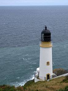 | Maughold Head 54°17.734′N 4°18.585′W / 54.295567°N 4.309750°W | 1914 | 23 m (75 ft) | 65 m (213 ft) | 21 nmi (39 km) | Designed by Charles Stevenson |
| Point of Ayre |  | Point of Ayre 54°24.959′N 4°22.111′W / 54.415983°N 4.368517°W | 1818 | 30 m (98 ft) | 32 m (105 ft) | 19 nmi (35 km) | Designed by Robert Stevenson |
| Point of Ayre Winkie |  | Point of Ayre 54°24.959′N 4°22.111′W / 54.415983°N 4.368517°W | 1888 | 10 m (33 ft) | 10 m (33 ft) | Inactive | Inactive since 2010 |
| Port Erin Range Front |  | Port Erin 54°05′14″N 4°45′34″W / 54.0872°N 4.7594°W | Unknown | 11 m (36 ft) | 10 m (33 ft) | 5 nmi (9 km) | Operated by Isle of Man Harbours |
| Thousla Rock |  | Calf Sound 54°03′44″N 4°48′02″W / 54.06215°N 4.80065°W | 1981 | 9 m (30 ft) | 9 m (30 ft) | 4 nmi (7 km) | Octagonal pillar, displays a flashing red light. |
See also
- List of Northern Lighthouse Board lighthouses
- List of lighthouses in the United Kingdom
- Lists of lighthouses and lightvessels
References
- ↑ Rowlett, Russ. "Lighthouses of the Isle of Man". The Lighthouse Directory. University of North Carolina at Chapel Hill. Retrieved 5 July 2015.
External links
![]() Media related to Lighthouses in the Isle of Man at Wikimedia Commons
Media related to Lighthouses in the Isle of Man at Wikimedia Commons
- Lighthouses of the Isle of Man at University of North Carolina at Chapel Hill's The Lighthouse Directory
| Types |
| _-_cropped.jpg) | ||||||||||
|---|---|---|---|---|---|---|---|---|---|---|---|---|
| Fixtures | ||||||||||||
| Maintenance |
| |||||||||||
| Individual lighthouses |
| |||||||||||
| Museums |
| |||||||||||
| Other organizations | ||||||||||||
| ||||||||||||
This article is issued from Wikipedia - version of the 12/2/2016. The text is available under the Creative Commons Attribution/Share Alike but additional terms may apply for the media files.