List of municipalities in Nova Scotia

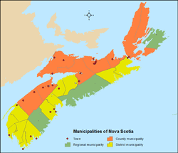
Nova Scotia is the seventh-most populous of Canada's provinces and territories with 921,727 residents as of 2011 and is the second-smallest province in land area at approximately 53,000 km2 (20,000 sq mi).[1] Nova Scotia's 51 incorporated municipalities are either regional municipalities, rural municipalities (county municipalities or district municipalities), or towns. Municipalities in Nova Scotia are incorporated under the Municipal Government Act (MGA).[2] This act gives municipal councils the power to make bylaws for "health, well being, safety and protection of persons" and "safety and protection of property" in addition to a few expressed powers.[3]
Municipalities
Regional municipalities
Nova Scotia has three regional municipalities. The largest regional municipality by population is Halifax, which is the capital and largest municipality of Nova Scotia by population. Halifax's 390,096 residents represent 42% of the total population of the province. Halifax is also the largest municipality by land area at 5,490.28 km2 (2,119.81 sq mi).[4]
Rural municipalities
County municipalities
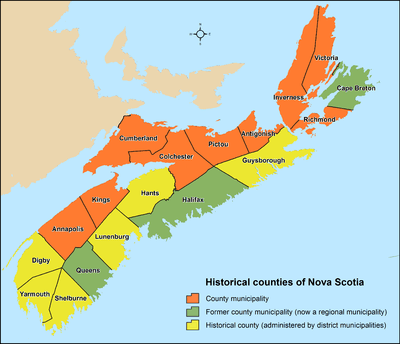
Of Nova Scotia's 18 historical counties, 9 are incorporated as county municipalities. Of the remaining 9 counties, 3 are now regional municipalities, while municipal governance in the remaining 6 is provided at the local level through a combination of district municipalities and towns.
District municipalities
Nova Scotia has 12 district municipalities. Nova Scotia's largest and smallest district municipalities by population are Lunenburg and St. Mary's with 25,118 and 2,354 residents respectively.[4] Nova Scotia's largest district municipality by size is Guysborough which spans 2,111.42 km2 (815.22 sq mi) and the smallest by size is Yarmouth at 585.75 km2 (226.16 sq mi).[4]
Towns

A town is a type of municipality in the Canadian Province of Nova Scotia. Towns are incorporated by order by the Nova Scotia Utility and Review Board pursuant to sections 383 through 388 of Nova Scotia's MGA.[5]
Nova Scotia had 31 towns at the time of the 2011 Census.[4] This total has since been reduced to 27 due to the dissolution of the towns of:
- Canso on July 1, 2012 to become part of the Municipality of the District of Guysborough;[6][7]
- Bridgetown on April 1, 2015 to become part of the Municipality of the County of Annapolis;[6]
- Springhill on April 1, 2015 to become part of the Municipality of the County of Cumberland;[6] and
- Hantsport on July 1, 2015 to become part of the Municipality of the District of West Hants.[8]
In the 2011 Census, the remaining 27 towns had a cumulative population of 100,588 and an average population of 3,725. Nova Scotia's largest and smallest towns by population are Truro and Annapolis Royal with 12,059 and 481 residents respectively.[4] These two towns are also Nova Scotia's largest and smallest by land area at 37.63 km2 (14.53 sq mi) and 2.04 km2 (0.79 sq mi) respectively.[4]
List of municipalities

| Municipal type | Population (2011) |
Population (2006) |
Change (%) |
Land area (km²) |
Population density | |
|---|---|---|---|---|---|---|
| Cape Breton | Regional municipality | 97,398 | 102,250 | −4.7% | 2,433.35 | 40.0/km2 |
| Halifax | Regional municipality | 390,096 | 372,679 | +4.7% | 5,490.28 | 71.1/km2 |
| Queens | Regional municipality | 10,917 | 11,177 | −2.3% | 2,392.85 | 4.6/km2 |
| Annapolis[lower-alpha 1] | County municipality | 18,526 | 19,165 | −3.3% | 3,177.49 | 5.8/km2 |
| Antigonish[lower-alpha 2] | County municipality | 15,065 | 14,600 | +3.2% | 1,452.67 | 10.4/km2 |
| Colchester[lower-alpha 3] | County municipality | 37,489 | 36,837 | +1.8% | 3,572.39 | 10.5/km2 |
| Cumberland[lower-alpha 4] | County municipality | 19,180 | 19,962 | −3.9% | 4,233.48 | 4.5/km2 |
| Inverness[lower-alpha 5] | County municipality | 14,581 | 15,519 | −6.0% | 3,822.29 | 3.8/km2 |
| Kings[lower-alpha 6] | County municipality | 47,772 | 47,994 | −0.5% | 2,091.72 | 22.8/km2 |
| Pictou[lower-alpha 7] | County municipality | 21,745 | 21,982 | −1.1% | 2,798.01 | 7.8/km2 |
| Richmond | County municipality | 9,293 | 9,740 | −4.6% | 1,244.24 | 7.5/km2 |
| Victoria | County municipality | 7,115 | 7,594 | −6.3% | 2,870.85 | 2.5/km2 |
| Argyle | District municipality | align=center rowspan=1 bgcolor=#F9F9F9|8,252 | 8,656 | −4.7% | 1,528.10 | 5.4/km2 |
| Barrington | District municipality | align=center rowspan=1 bgcolor=#F9F9F9|6,994 | 7,331 | −4.6% | 631.94 | 11.1/km2 |
| Chester | District municipality | align=center rowspan=1 bgcolor=#F9F9F9|10,599 | 10,741 | −1.3% | 1,122.22 | 9.4/km2 |
| Clare | District municipality | align=center rowspan=1 bgcolor=#F9F9F9|8,319 | 8,813 | −5.6% | 852.82 | 9.8/km2 |
| Digby | District municipality | align=center rowspan=1 bgcolor=#F9F9F9|7,463 | 7,986 | −6.5% | 1,655.88 | 4.5/km2 |
| East Hants | District municipality | align=center rowspan=1 bgcolor=#F9F9F9|22,111 | 21,397 | +3.3% | 1,786.47 | 12.4/km2 |
| Guysborough | District municipality | align=center rowspan=1 bgcolor=#F9F9F9|4,189 | 4,681 | −10.5% | 2,111.42 | 2.0/km2 |
| Lunenburg | District municipality | align=center rowspan=1 bgcolor=#F9F9F9|25,118 | 25,164 | −0.2% | 1,759.64 | 14.3/km2 |
| Shelburne | District municipality | align=center rowspan=1 bgcolor=#F9F9F9|4,408 | 4,828 | −8.7% | 1,818.49 | 2.4/km2 |
| St. Mary's | District municipality | align=center rowspan=1 bgcolor=#F9F9F9|2,354 | 2,587 | −9.0% | 1,909.59 | 1.2/km2 |
| West Hants | District municipality | align=center rowspan=1 bgcolor=#F9F9F9|14,165 | 13,871 | +2.1% | 1,241.95 | 11.4/km2 |
| Yarmouth | District municipality | align=center rowspan=1 bgcolor=#F9F9F9|10,105 | 10,304 | −1.9% | 585.75 | 17.3/km2 |
| Amherst | Town | 9,717 | 9,505 | +2.2% | 12.02 | 808.4/km2 |
| Annapolis Royal | Town | 481 | 444 | +8.3% | 2.04 | 235.8/km2 |
| Antigonish | Town | 4,524 | 4,236 | +6.8% | 5.15 | 878.4/km2 |
| Berwick | Town | 2,454 | 2,454 | 0.0% | 6.66 | 368.5/km2 |
| Bridgewater | Town | 8,241 | 7,944 | +3.7% | 13.60 | 606.0/km2 |
| Clark's Harbour | Town | 820 | 860 | −4.7% | 2.90 | 282.8/km2 |
| Digby | Town | 2,152 | 2,092 | +2.9% | 3.14 | 685.4/km2 |
| Kentville | Town | 6,094 | 5,815 | +4.8% | 17.35 | 351.2/km2 |
| Lockeport | Town | 588 | 646 | −9.0% | 2.32 | 253.4/km2 |
| Lunenburg | Town | 2,313 | 2,317 | −0.2% | 4.01 | 576.8/km2 |
| Mahone Bay | Town | 943 | 904 | +4.3% | 3.13 | 301.3/km2 |
| Middleton | Town | 1,749 | 1,829 | −4.4% | 5.44 | 321.5/km2 |
| Mulgrave | Town | 794 | 879 | −9.7% | 17.81 | 44.6/km2 |
| New Glasgow | Town | 9,562 | 9,455 | +1.1% | 9.93 | 962.9/km2 |
| Oxford | Town | 1,151 | 1,178 | −2.3% | 10.76 | 107.0/km2 |
| Parrsboro | Town | 1,305 | 1,401 | −6.9% | 14.88 | 87.7/km2 |
| Pictou | Town | 3,437 | 3,813 | −9.9% | 7.94 | 432.9/km2 |
| Port Hawkesbury | Town | 3,366 | 3,517 | −4.3% | 8.11 | 415.0/km2 |
| Shelburne | Town | 1,686 | 1,879 | −10.3% | 9.00 | 187.3/km2 |
| Stellarton | Town | 4,485 | 4,717 | −4.9% | 8.99 | 498.9/km2 |
| Stewiacke | Town | 1,438 | 1,421 | +1.2% | 17.67 | 81.4/km2 |
| Trenton | Town | 2,616 | 2,741 | −4.6% | 6.00 | 436.0/km2 |
| Truro | Town | 12,059 | 11,765 | +2.5% | 37.63 | 320.5/km2 |
| Westville | Town | 3,798 | 3,805 | −0.2% | 14.39 | 263.9/km2 |
| Windsor | Town | 3,785 | 3,709 | +2.0% | 9.06 | 417.8/km2 |
| Wolfville | Town | 4,269 | 3,772 | +13.2% | 6.45 | 661.9/km2 |
| Yarmouth | Town | 6,761 | 7,162 | −5.6% | 10.56 | 640.2/km2 |
| Total regional municipalities | — | 498,411 | 486,106 | +2.5% | 10,316.48 | 48.3/km2 |
| Total county municipalities | — | 190,766 | 193,393 | −1.4% | 25,263.14 | 7.6/km2 |
| Total district municipalities | — | 124,077 | 126,359 | −1.8% | 17,004.18 | 7.3/km2 |
| Total towns | — | 100,588 | 100,260 | +0.3% | 266.94 | 376.8/km2 |
| Total municipalities | — | 913,842 | 906,118 | +0.9% | 52,850.83 | 17.3/km2 |
Former municipalities
Nova Scotia has undergone reforms to local government in the last few decades, which has seen various municipalities dissolve into surrounding municipalities or amalgamate to form larger municipalities. The Municipality of the County of Cape Breton, the City of Sydney, and the towns of Dominion, Glace Bay, Louisbourg, New Waterford, North Sydney, and Sydney Mines dissolved and amalgamated on April 1, 1995 to form the Cape Breton Regional Municipality. The City of Halifax along with the City of Dartmouth, Town of Bedford, and Municipality of the County of Halifax also dissolved and amalgamated on April 1, 1996 to become the Halifax Regional Municipality.
See also
- Demographics of Nova Scotia
- Geography of Nova Scotia
- List of census agglomerations in Atlantic Canada
- List of communities in Nova Scotia
- List of counties of Nova Scotia
- List of designated places in Nova Scotia
- List of population centres in Nova Scotia
- List of towns in Nova Scotia
- List of villages in Nova Scotia
Notes
- ↑ Figures exclude the incorporated towns of Annapolis Royal and Middleton.
- ↑ Figures exclude the incorporated town of Antigonish.
- ↑ Figures exclude the incorporated towns of Stewiacke and Truro.
- ↑ Figures exclude the incorporated towns of Amherst, Oxford, and Parrsboro.
- ↑ Figures exclude the incorporated town of Port Hawkesbury.
- ↑ Figures exclude the incorporated towns of Berwick, Kentville, and Wolfville.
- ↑ Figures exclude the incorporated towns of New Glasgow, Pictou, Stellarton, Trenton, and Westville.
References
- ↑ "Population and dwelling counts, for Canada, provinces and territories, 2011 and 2006 censuses". Statistics Canada. January 13, 2014. Retrieved November 22, 2014.
- ↑ http://www.canlii.org/en/ns/laws/stat/sns-1998-c-18/latest/part-1/sns-1998-c-18-part-1.pdf
- ↑ http://www.community.gov.yk.ca/pdf/ma_pt.pdf
- 1 2 3 4 5 6 "Population and dwelling counts, for Canada, provinces and territories, and census subdivisions (municipalities), 2011 and 2006 censuses (Nova Scotia)". Statistics Canada. December 18, 2012. Retrieved January 29, 2013.
- ↑ "Municipal Government Act". Office of the Legislative Counsel, Nova Scotia House of Assembly. June 19, 2012. Retrieved January 29, 2013.
- 1 2 3 "Nova Scotia Annual Report of Municipal Statistics for the fiscal year ended March 31, 2014" (PDF). Nova Scotia Department of Municipal Affairs. pp. 2, 11. Retrieved January 1, 2016.
- ↑ "Decision NSUARB-MB-10-2" (PDF). Nova Scotia Utility and Review Board. January 19, 2012. Retrieved January 29, 2013.
- ↑ "Current Events News: Notice to Hantsport Residents – Special Election District 8". Municipality of the Town of Hantsport. Retrieved January 1, 2016.
| Counties | |
|---|---|
| Economic Regions | |
| Regional municipalities | |
| Municipal districts | |
| Towns | |
| Incorporated villages | |
| Lists | |
| |
| Provinces | |
|---|---|
| Territories | |
| |