Lee County, Alabama
| Lee County, Alabama | |
|---|---|
.jpg) Lee County courthouse in Opelika | |
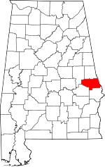 Location in the U.S. state of Alabama | |
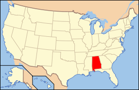 Alabama's location in the U.S. | |
| Founded | December 5, 1866 |
| Named for | Robert E. Lee |
| Seat | Opelika |
| Largest city | Auburn |
| Area | |
| • Total | 616 sq mi (1,595 km2) |
| • Land | 608 sq mi (1,575 km2) |
| • Water | 8.3 sq mi (21 km2), 1.3% |
| Population (est.) | |
| • (2015) | 156,993 |
| • Density | 254/sq mi (98/km²) |
| Congressional district | 3rd |
| Time zone | Central: UTC-6/-5 |
| Website |
www |
|
Footnotes:
| |
Lee County is a county of the U.S. state of Alabama. As of the 2010 census the population was 140,247.[1] The county seat is Opelika,[2] and the largest city is Auburn. The county is named after Robert E. Lee,[3] commanding general of the Army of Northern Virginia, and one of the most senior officers in the Confederate Army.
Lee County comprises the Auburn-Opelika, AL Metropolitan Statistical Area, which is included in the Columbus-Auburn-Opelika, GA-AL Combined Statistical Area.
History
Lee County was established by act of the Alabama state legislature on December 5, 1866, out of parts of Macon, Tallapoosa, Chambers, and Russell Counties. In an election to determine the county seat, Opelika was chosen over Auburn and Salem.
In 1923, the town of Phenix City, located in the southeastern corner of Lee County, merged with the town of Girard, located in the northeastern corner of Russell County. To prevent the new town of Phenix City from straddling the Lee-Russell line, Lee County ceded to Russell County the 10 square miles (25.9 km2) in the southeastern corner surrounding Phenix City in exchange for 20 square miles (51.8 km2) in the northwest corner of Russell County surrounding the unincorporated community of Marvyn. This new territory is what forms the southern "panhandle" of Lee County.
Politics and government
Among the principal governmental functions vested in Alabama counties are law enforcement; tax assessment, levy and collection; administration of decedent's estates and probate matters; maintenance of real and personal property title records; construction and maintenance of public roads and bridges; and maintenance of the county courthouse, which provides office space for various county officials and departments.
Lee County is governed by a six-member County Commission, composed of a Chairman and five Commissioners. The Probate Judge, who serves as Chairman of the County Commission, is elected countywide for a six-year term. The other five members of the County Commission are elected from single-member districts for four-year terms. Each Commissioner must be a registered voter and live within the district they represent. Commissioners are not all elected at the same time. Three commissioners are elected in one election cycle, and the other two members are elected in the next election cycle two years later, so that the terms are staggered for continuity.
The County Commission employs a County Administrator, who serves as its chief administrative officer. It is the responsibility of the County Administrator to carry out the policies and directives of the Commission, and for the development and management of the County's annual operating budget. The Administrator serves as the budgetary agent for all county offices. The County Administrator is also responsible for the supervision and management of various department heads, and for ensuring that all agreements, leases and other contractual obligations of the Commission are properly performed. The County Administrator works with Lee County Commissioners and other elected county officials to facilitate the delivery of quality and effective services to the citizens of Lee County.[4]
Geography
According to the U.S. Census Bureau, the county has a total area of 616 square miles (1,600 km2), of which 608 square miles (1,570 km2) is land and 8.3 square miles (21 km2) (1.3%) is water.[5]
Major highways
Adjacent counties
- Chambers County (north)
- Harris County, Georgia (northeast)
- Muscogee County, Georgia (east)
- Russell County (south)
- Macon County (southwest)
- Tallapoosa County (northwest)
Demographics
| Historical population | |||
|---|---|---|---|
| Census | Pop. | %± | |
| 1870 | 21,750 | — | |
| 1880 | 27,262 | 25.3% | |
| 1890 | 28,694 | 5.3% | |
| 1900 | 31,826 | 10.9% | |
| 1910 | 32,867 | 3.3% | |
| 1920 | 32,821 | −0.1% | |
| 1930 | 36,063 | 9.9% | |
| 1940 | 36,455 | 1.1% | |
| 1950 | 45,073 | 23.6% | |
| 1960 | 49,754 | 10.4% | |
| 1970 | 61,268 | 23.1% | |
| 1980 | 76,283 | 24.5% | |
| 1990 | 87,146 | 14.2% | |
| 2000 | 115,092 | 32.1% | |
| 2010 | 140,247 | 21.9% | |
| Est. 2015 | 156,993 | [6] | 11.9% |
| U.S. Decennial Census[7] 1790–1960[8] 1900–1990[9] 1990–2000[10] 2010–2015[1] | |||
As of the census[11] of 2000, there were 115,092 people, 45,702 households, and 27,284 families residing in the county. The population density was 189 people per square mile (73/km2). There were 50,329 housing units at an average density of 83 per square mile (32/km2). The racial makeup of the county was 74.07% White, 22.65% Black or African American, 0.24% Native American, 1.63% Asian, 0.02% Pacific Islander, 0.46% from other races, and 0.93% from two or more races. 1.43% of the population were Hispanic or Latino of any race.
There were 45,702 households out of which 29.70% had children under the age of 18 living with them, 44.10% were married couples living together, 11.80% had a female householder with no husband present, and 40.30% were non-families. 27.80% of all households were made up of individuals and 5.70% had someone living alone who was 65 years of age or older. The average household size was 2.42 and the average family size was 3.03.
In the county the population was spread out with 23.30% under the age of 18, 22.70% from 18 to 24, 28.10% from 25 to 44, 17.80% from 45 to 64, and 8.10% who were 65 years of age or older. The median age was 28 years. For every 100 females there were 96.90 males. For every 100 females age 18 and over, there were 95.20 males.
The median income for a household in the county was $30,952, and the median income for a family was $46,781. Males had a median income of $33,598 versus $23,228 for females. The per capita income for the county was $17,158. About 11.10% of families and 21.80% of the population were below the poverty line, including 16.30% of those under age 18 and 12.00% of those age 65 or over.
2010 census
As of the census[11] of 2010, there were 140,247 people, 55,682 households, and 33,692 families residing in the county. The population density was 227.7 people per square mile (87.9/km2). There were 62,391 housing units at an average density of 101.3 per square mile (39.1/km2). The racial makeup of the county was 71.3% White, 22.7% Black or African American, 0.3% Native American, 2.6% Asian, 0.1% Pacific Islander, 1.3% from other races, and 1.6% from two or more races. 3.3% of the population were Hispanic or Latino of any race.
There were 55,682 households out of which 28.0% had children under the age of 18 living with them, 43.1% were married couples living together, 13.0% had a female householder with no husband present, and 39.5% were non-families. 27.9% of all households were made up of individuals and 6.0% had someone living alone who was 65 years of age or older. The average household size was 2.44 and the average family size was 3.03.
In the county the population was spread out with 22.5% under the age of 18, 20.5% from 18 to 24, 26.1% from 25 to 44, 21.8% from 45 to 64, and 9.1% who were 65 years of age or older. The median age was 28.3 years. For every 100 females there were 97.2 males. For every 100 females age 18 and over, there were 98.0 males.
The median income for a household in the county was $40,894, and the median income for a family was $59,112. Males had a median income of $42,335 versus $31,766 for females. The per capita income for the county was $22,794. About 11.0% of families and 19.2% of the population were below the poverty line, including 19.0% of those under age 18 and 9.0% of those age 65 or over.
Education
Auburn University, a large comprehensive public university, is located in Auburn in Lee County. Southern Union State Community College, a two-year degree and technical college, is located in Opelika, Alabama, in Lee County.
Government
| Year | GOP | DNC | Others |
|---|---|---|---|
| 2016 | 58.6% 34,321 | 35.8% 20,987 | 5.6% 3,299 |
| 2012 | 59.3% 32,062 | 39.3% 21,274 | 1.4% 779 |
| 2008 | 59.3% 32,230 | 39.6% 21,498 | 1.1% 597 |
| 2004 | 62.7% 27,972 | 36.4% 16,227 | 0.9% 411 |
| 2000 | 58.6% 22,433 | 38.1% 14,574 | 3.3% 1,257 |
Communities


Cities
- Auburn
- Opelika (county seat)
- Phenix City (partly in Russell County)
- Smiths Station
Towns
- Loachapoka
- Notasulga (partly in Macon County)
- Waverly (partly in Chambers County)
Unincorporated communities
Places of interest
Lee County is home to Chewacla State Park, the Jule Collins Smith Museum of Fine Art, Bean's Mill, the Salem-Shotwell Covered Bridge and the Grand National Golf course which is part of the Robert Trent Jones Golf Trail.
Gallery
 Lee County Sheriff's Department administration and Detention Center in Opelika
 Lee County Courthouse Auburn Satellite Office - Auburn
 Lee County Lake
 Map illustrating the original boundaries of Lee County and the counties from which it was carved
See also
- National Register of Historic Places listings in Lee County, Alabama
- Properties on the Alabama Register of Landmarks and Heritage in Lee County, Alabama
References
- 1 2 "State & County QuickFacts". United States Census Bureau. Retrieved May 16, 2014.
- ↑ "Find a County". National Association of Counties. Retrieved 2011-06-07.
- ↑ Gannett, Henry (1905). The Origin of Certain Place Names in the United States. U.S. Government Printing Office. p. 184.
- ↑ Text on Lee County government used with permission of Lee County Commissioners Office.
- ↑ "2010 Census Gazetteer Files". United States Census Bureau. August 22, 2012. Retrieved August 22, 2015.
- ↑ "County Totals Dataset: Population, Population Change and Estimated Components of Population Change: April 1, 2010 to July 1, 2015". Retrieved July 2, 2016.
- ↑ "U.S. Decennial Census". United States Census Bureau. Retrieved August 22, 2015.
- ↑ "Historical Census Browser". University of Virginia Library. Retrieved August 22, 2015.
- ↑ Forstall, Richard L., ed. (March 24, 1995). "Population of Counties by Decennial Census: 1900 to 1990". United States Census Bureau. Retrieved August 22, 2015.
- ↑ "Census 2000 PHC-T-4. Ranking Tables for Counties: 1990 and 2000" (PDF). United States Census Bureau. April 2, 2001. Retrieved August 22, 2015.
- 1 2 "American FactFinder". United States Census Bureau. Retrieved 2011-05-14.
- ↑ "Dave Leip's Atlas of U.S. Presidential Elections". Retrieved November 21, 2016.
- Barnes, Margaret Anne (1998). The Tragedy and the Triumph of Phenix City, Alabama. Macon, Ga., Mercer University Press. ISBN 0-86554-613-4
- Nunn, Alexander (Ed.) (1983). Lee County and Her Forebears. Montgomery, Ala., Herff Jones. LCCCN 83-081693
- Wright, John Peavy (1969). Glimpses into the past from my Grandfather's Trunk. Alexander City, Ala., Outlook Publishing Company, Inc. LCCCN 74-101331
 |
Tallapoosa County | Chambers County | Harris County, Georgia | |
| |
Muscogee County, Georgia | |||
| ||||
| | ||||
| Macon County | Russell County |
Municipalities and communities of Lee County, Alabama, United States | ||
|---|---|---|
| Cities | | |
| Towns | ||
| Unincorporated communities | ||
| Footnotes | ‡This populated place also has portions in an adjacent county or counties | |
| Central cities/Largest cities | 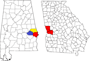 Location of the Columbus, Georgia-Auburn, Alabama CSA and its counties:
Columbus, Georgia Metropolitan Statistical Area
Auburn, Alabama Metropolitan Statistical Area
Tuskegee, Alabama Micropolitan Statistical Area (defunct) | |
|---|---|---|
| Cities in Georgia | ||
| Cities in Alabama | ||
| Counties in Georgia | ||
| Counties in Alabama | ||
Coordinates: 32°36′05″N 85°21′13″W / 32.60139°N 85.35361°W