Le Bleymard
| Le Bleymard | ||
|---|---|---|
|
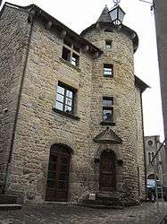
The town hall of Le Bleymard | ||
| ||
 Le Bleymard | ||
|
Location within Occitanie region  Le Bleymard | ||
| Coordinates: 44°29′14″N 3°44′09″E / 44.4872°N 3.7358°ECoordinates: 44°29′14″N 3°44′09″E / 44.4872°N 3.7358°E | ||
| Country | France | |
| Region | Occitanie | |
| Department | Lozère | |
| Arrondissement | Mende | |
| Canton | Le Bleymard | |
| Intercommunality | Goulet-Mont Lozère | |
| Government | ||
| • Mayor (2008–2014) | Claude Bergounhe | |
| Area1 | 16.36 km2 (6.32 sq mi) | |
| Population (2009)2 | 347 | |
| • Density | 21/km2 (55/sq mi) | |
| Time zone | CET (UTC+1) | |
| • Summer (DST) | CEST (UTC+2) | |
| INSEE/Postal code | 48027 / 48190 | |
| Elevation |
1,037–1,482 m (3,402–4,862 ft) (avg. 1,069 m or 3,507 ft) | |
|
1 French Land Register data, which excludes lakes, ponds, glaciers > 1 km² (0.386 sq mi or 247 acres) and river estuaries. 2 Population without double counting: residents of multiple communes (e.g., students and military personnel) only counted once. | ||

Le Bleymard is a commune in the Lozère department in southern France.
Population
| Historical population | ||
|---|---|---|
| Year | Pop. | ±% |
| 1793 | 752 | — |
| 1800 | 748 | −0.5% |
| 1806 | 749 | +0.1% |
| 1821 | 486 | −35.1% |
| 1831 | 583 | +20.0% |
| 1836 | 597 | +2.4% |
| 1841 | 583 | −2.3% |
| 1846 | 596 | +2.2% |
| 1851 | 652 | +9.4% |
| 1856 | 610 | −6.4% |
| 1861 | 553 | −9.3% |
| 1866 | 540 | −2.4% |
| 1872 | 575 | +6.5% |
| 1876 | 600 | +4.3% |
| 1881 | 678 | +13.0% |
| 1886 | 665 | −1.9% |
| 1891 | 605 | −9.0% |
| 1896 | 649 | +7.3% |
| 1901 | 598 | −7.9% |
| 1906 | 621 | +3.8% |
| 1911 | 697 | +12.2% |
| 1921 | 553 | −20.7% |
| 1926 | 575 | +4.0% |
| 1931 | 549 | −4.5% |
| 1936 | 448 | −18.4% |
| 1946 | 493 | +10.0% |
| 1954 | 336 | −31.8% |
| 1962 | 324 | −3.6% |
| 1968 | 295 | −9.0% |
| 1975 | 358 | +21.4% |
| 1982 | 434 | +21.2% |
| 1990 | 440 | +1.4% |
| 1999 | 446 | +1.4% |
| 2006 | 367 | −17.7% |
| 2009 | 347 | −5.4% |
Personalities
- Alphonse Magnien (1837-1902), Catholic educator
- Henri Rouvière (1876-1952), Professor of anatomy
See also
References
External links
| Wikimedia Commons has media related to Le Bleymard. |
- Le Bleymard in Lozere (separate texts in French, Dutch and German; photographs)
This article is issued from Wikipedia - version of the 2/11/2016. The text is available under the Creative Commons Attribution/Share Alike but additional terms may apply for the media files.