Gatuzières
| Gatuzières | ||
|---|---|---|
|
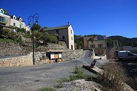
A view within Gatuzières | ||
| ||
 Gatuzières | ||
|
Location within Occitanie region  Gatuzières | ||
| Coordinates: 44°11′58″N 3°29′26″E / 44.1994°N 3.4906°ECoordinates: 44°11′58″N 3°29′26″E / 44.1994°N 3.4906°E | ||
| Country | France | |
| Region | Occitanie | |
| Department | Lozère | |
| Arrondissement | Florac | |
| Canton | Meyrueis | |
| Intercommunality | Vallée de la Jonte | |
| Government | ||
| • Mayor (2008–2014) | Michel Commandre[1] | |
| Area1 | 29.40 km2 (11.35 sq mi) | |
| Population (1999)2 | 55 | |
| • Density | 1.9/km2 (4.8/sq mi) | |
| Time zone | CET (UTC+1) | |
| • Summer (DST) | CEST (UTC+2) | |
| INSEE/Postal code | 48069 / 48150 | |
| Elevation |
759–1,562 m (2,490–5,125 ft) (avg. 825 m or 2,707 ft) | |
|
1 French Land Register data, which excludes lakes, ponds, glaciers > 1 km² (0.386 sq mi or 247 acres) and river estuaries. 2 Population without double counting: residents of multiple communes (e.g., students and military personnel) only counted once. | ||


Church of Notre-Dame in Gatuzières.
Gatuzières is a commune in the Lozère department in southern France.
See also
References
| Wikimedia Commons has media related to Gatuzières. |
This article is issued from Wikipedia - version of the 2/10/2016. The text is available under the Creative Commons Attribution/Share Alike but additional terms may apply for the media files.