Laurel Springs, North Carolina
| Laurel Springs, North Carolina | |
|---|---|
| Unincorporated community | |
|
Entering Laurel Springs | |
 Laurel Springs, North Carolina  Laurel Springs, North Carolina | |
| Coordinates: 36°24′41″N 81°15′46″W / 36.41139°N 81.26278°WCoordinates: 36°24′41″N 81°15′46″W / 36.41139°N 81.26278°W | |
| Country | United States |
| State | North Carolina |
| County | Alleghany |
| Elevation | 2,749 ft (838 m) |
| Time zone | Eastern (EST) (UTC-5) |
| • Summer (DST) | EDT (UTC-4) |
| ZIP code | 28644 |
| Area code(s) | 336 |
| GNIS feature ID | 1021119[1] |
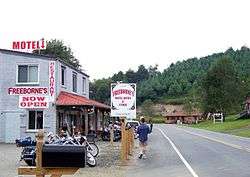
Laurel Springs is an unincorporated community in Alleghany County, North Carolina, United States. Laurel Springs is located at the junction of North Carolina Highway 18 and North Carolina Highway 88 near the Ashe County line, 10.2 miles (16.4 km) southwest of Sparta.[2] Laurel Springs has a post office with ZIP code 28644.[3][4]
The Robert L. Doughton House was listed on the National Register of Historic Places in 1979.[5]
References
- ↑ "Laurel Springs". Geographic Names Information System. United States Geological Survey.
- ↑ Alleghany County, North Carolina (Map). North Carolina Department of Transportation. 2009.
- ↑ United States Postal Service (2012). "USPS - Look Up a ZIP Code". Retrieved 2012-02-15.
- ↑ "Postmaster Finder - Post Offices by ZIP Code". United States Postal Service. Retrieved March 24, 2013.
- ↑ National Park Service (2010-07-09). "National Register Information System". National Register of Historic Places. National Park Service.
Municipalities and communities of Alleghany County, North Carolina, United States | ||
|---|---|---|
| Town |  | |
| Unincorporated communities | ||
This article is issued from Wikipedia - version of the 11/17/2016. The text is available under the Creative Commons Attribution/Share Alike but additional terms may apply for the media files.