Latour-de-France
| Latour-de-France La Tor de Trinhac | ||
|---|---|---|
|
The road into Latour-de-France | ||
| ||
 Latour-de-France | ||
|
Location within Occitanie region  Latour-de-France | ||
| Coordinates: 42°46′10″N 2°39′14″E / 42.7694°N 2.6539°ECoordinates: 42°46′10″N 2°39′14″E / 42.7694°N 2.6539°E | ||
| Country | France | |
| Region | Occitanie | |
| Department | Pyrénées-Orientales | |
| Arrondissement | Perpignan | |
| Canton | Latour-de-France | |
| Intercommunality | Agly Fenouillèdes | |
| Government | ||
| • Mayor (2008–2014) | Jean-José Colomes | |
| Area1 | 13.94 km2 (5.38 sq mi) | |
| Population (2005)2 | 1,046 | |
| • Density | 75/km2 (190/sq mi) | |
| Time zone | CET (UTC+1) | |
| • Summer (DST) | CEST (UTC+2) | |
| INSEE/Postal code | 66096 / 66720 | |
| Elevation |
77–422 m (253–1,385 ft) (avg. 85 m or 279 ft) | |
|
1 French Land Register data, which excludes lakes, ponds, glaciers > 1 km² (0.386 sq mi or 247 acres) and river estuaries. 2 Population without double counting: residents of multiple communes (e.g., students and military personnel) only counted once. | ||
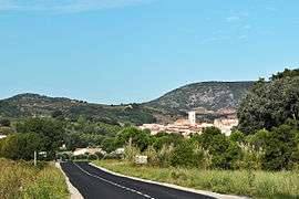

Latour-de-France (Occitan: La Tor de Trinhac, La Tor de França) is a commune in the Pyrénées-Orientales department in southern France.
Latour de France is situated by the original frontier between France and Catalonia and is rich in history. Its military significance ended with the Treaty of the Pyrenees peace between Louis XIV of France and Philip IV of Spain that ended the Franco-Spanish War of 1648–59 but is still evinced in street names such as place de l’hôpital and place d’Armes.
This little village of approximately 1,000 inhabitants boasts its own Appellation Contrôlée associated with the forward-looking cave co-operative, a garage, grocery, bakers, tobacconist, and blacksmith. There are two tennis courts, a charming children's playground, and several locations used by petanque enthusiasts.
At its perimeter, there is a mix of ancient and modern while the old central village is a labyrinth of narrow streets. While the Mairie has assiduously maintained and developed its many hidden small squares, the village has managed to remain unspoilt and authentic.
Thirty years ago, in common with many villages, there were a fair number of derelict properties. These have virtually disappeared having been renovated for the most part by local families. There are few foreigners in Latour de France. The few who are there have always found a real welcome and look on it as a little piece of heaven.
There are many well-mapped walking and biking trails through the vineyards with points of interest such as derelict chapels, mines, etc. – all surrounded by scenic views of the mountains.
Geography
Latour-de-France is located in the canton of Latour-de-France and in the arrondissement of Perpignan.

Toponymy
Latour-de-France is called La Tor de França in Catalan and La Tor de Trinhac or La Tor de Fenolledes in Occitan.[1]
The first known name is Turris Triniago in 1020 (tower of Triniach). The name Tor de Fenolledés appears in 1423 (tower of the Fenouillèdes). This name will remain until the 18th century. La Tour de France appears in 1750 and is the name used today.[1]
Population

Sites of interest
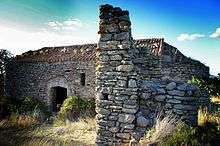
The village is dominated by a castle which has its origins in the 11th century, but most of the present structure is from the 16th and 17th centuries. It stands at the highest point of the village, perched on a hill overlooking three valleys.
- Saint Martin chapel, from the 13th century.
See also
References
Notes
External links
| Wikimedia Commons has media related to Latour-de-France. |