Réal
For other uses, see Real.
| Réal | |
|---|---|
|
View of Réal from the Formiguères road | |
 Réal | |
|
Location within Occitanie region  Réal | |
| Coordinates: 42°37′53″N 2°08′04″E / 42.6314°N 2.1344°ECoordinates: 42°37′53″N 2°08′04″E / 42.6314°N 2.1344°E | |
| Country | France |
| Region | Occitanie |
| Department | Pyrénées-Orientales |
| Arrondissement | Prades |
| Canton | Mont-Louis |
| Intercommunality | Capcir Haut-Conflent |
| Area1 | 10.45 km2 (4.03 sq mi) |
| Population (1999)2 | 31 |
| • Density | 3.0/km2 (7.7/sq mi) |
| Time zone | CET (UTC+1) |
| • Summer (DST) | CEST (UTC+2) |
| INSEE/Postal code | 66159 / 66210 |
| Elevation |
1,379–2,340 m (4,524–7,677 ft) (avg. 1,580 m or 5,180 ft) |
|
1 French Land Register data, which excludes lakes, ponds, glaciers > 1 km² (0.386 sq mi or 247 acres) and river estuaries. 2 Population without double counting: residents of multiple communes (e.g., students and military personnel) only counted once. | |

Réal (Catalan: Real) is a commune in the Pyrénées-Orientales department in southern France.
Geography
Réal is in the canton of Mont-Louis and in the arrondissement of Prades.
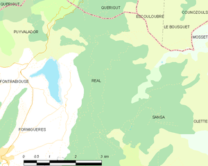
Map of Réal and its surrounding communes
Population

Population 1962-2008
Sites of interest
- The Saint-Romain church, built between the 11th and 17th centuries.
- The Puyvalador lake.
See also
References
| Wikimedia Commons has media related to Réal. |
This article is issued from Wikipedia - version of the 4/16/2016. The text is available under the Creative Commons Attribution/Share Alike but additional terms may apply for the media files.