Lamagistère
| Lamagistère | ||
|---|---|---|
|
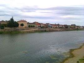
A view of the village from across the Garonne river | ||
| ||
 Lamagistère | ||
|
Location within Occitanie region  Lamagistère | ||
| Coordinates: 44°07′33″N 0°49′28″E / 44.1258°N 0.8244°ECoordinates: 44°07′33″N 0°49′28″E / 44.1258°N 0.8244°E | ||
| Country | France | |
| Region | Occitanie | |
| Department | Tarn-et-Garonne | |
| Arrondissement | Castelsarrasin | |
| Canton | Valence | |
| Intercommunality | Deux Rives | |
| Government | ||
| • Mayor (2008–2014) | Bernard Dousson | |
| Area1 | 9.1 km2 (3.5 sq mi) | |
| Population (2006)2 | 1,238 | |
| • Density | 140/km2 (350/sq mi) | |
| Time zone | CET (UTC+1) | |
| • Summer (DST) | CEST (UTC+2) | |
| INSEE/Postal code | 82089 / 82360 | |
| Elevation |
45–65 m (148–213 ft) (avg. 55 m or 180 ft) | |
|
1 French Land Register data, which excludes lakes, ponds, glaciers > 1 km² (0.386 sq mi or 247 acres) and river estuaries. 2 Population without double counting: residents of multiple communes (e.g., students and military personnel) only counted once. | ||
.svg.png)
Lamagistère is a commune in the Tarn-et-Garonne department in the Occitanie region in southern France. Inhabitants of the district are known as les Magistériens.
Geography
The district is located between the larger towns of Agen and Castelsarrasin. The nearest villages are Golfech, Donzac, Clermont-Soubiran, Saint-Urcisse and Saint-Sixte. The Barguelonne forms all of the commune's south-eastern border, then flows into the Garonne, which forms its southern and south-western borders. The commune, which is approximately 9 km2, is composed of a small village and surrounding territory.
The Route nationale N113 (national trunk road), used to run through the middle of the village but was later diverted around the town. In 2006, the French government downgraded some national trunk roads to departmental status roads. The N113 was one such road which was downgraded and now the diverted road is signed as the D813. However the historical designation can still be seen in a street sign in the middle of the village.

In fact the middle of the village is also a cross roads with the D30, which commences as a bridge over the Garonne River.
There is a train station in the middle of the town, on the Bordeaux-Toulouse line. The village has a public library and a school but lacks, in 2012, a cinema and museum.
History
During the second world war the district was at the heart of a Franco-American sabotage operation. On the night of 15 to 16 August 1944, a section of the train line running between Bordeaux and Toulouse, which was defended by a garrison of German soldiers, was attacked by a combined force of American commandos, French partisans from Lot and a company of the Armée Secrète of Tarn-et-Garonne.[1]
Demographics
The following table shows the recorded population of the commune according to INSEE[2]
| Year | Population |
|---|---|
| 1962 | 1189 |
| 1968 | 1192 |
| 1975 | 1153 |
| 1982 | 1084 |
| 1992 | 1248 |
| 1999 | 1187 |
Political Administration
The following table shows the names of the elected mayors of the commune in recent times and their period of tenure in the post.
| Period | Mayor |
|---|---|
| 2014-2020 | Philippe Longo |
| 2008-2014 | Bernard Dousson |
| 2001-2008 | Bernard Cassagne |
| 1989-2001 | André Simon |
| 1960-1989 | Jean Geoffroy |
See also
References
- ↑ J. Latu, L’opération de sabotages franco-américaine à Lamagistère, 15-16 août 1944, revue Arkheia, n°1, Montauban, 1999.
- ↑ Lamagistère sur le site de l'Insee
| Wikimedia Commons has media related to Lamagistère. |