Kulpara, South Australia
| Kulpara South Australia | |||||||||||||
|---|---|---|---|---|---|---|---|---|---|---|---|---|---|
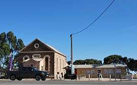 Cafe in the former church buildings at Kulpara | |||||||||||||
 Kulpara | |||||||||||||
| Coordinates | 34°04′S 138°02′E / 34.06°S 138.04°ECoordinates: 34°04′S 138°02′E / 34.06°S 138.04°E | ||||||||||||
| Established | 1864[1] | ||||||||||||
| Postcode(s) | 5555 | ||||||||||||
| Elevation | 117 m (384 ft)[2] | ||||||||||||
| Location |
| ||||||||||||
| LGA(s) | District Council of Barunga West | ||||||||||||
| State electorate(s) | Goyder | ||||||||||||
| Federal Division(s) | Grey | ||||||||||||
| |||||||||||||
Kulpara is a rural town in South Australia. It is on the Copper Coast Highway and Upper Yorke Road[3] in the Hummocks Range at the northern end of Yorke Peninsula.[4]
The name Kulpara is derived from an Aboriginal word Kula meaning Eucalyptus. The area was proclaimed in 1862, surveyed in 1864 and settled soon after. The township itself was surveyed in 1932 and proclaimed in 1934. A community hall was built in 1902, replaced by a soldiers' memorial hall in 1953. The school opened in 1877 and expanded in 1957. The Bible Christian church foundation stone was laid in 1879 with services starting soon after.[1] The church building is now a convenience store.[5]
It was the seat of its own municipality, the District Council of Kulpara, from 1878 to 1932.[6]
References
| Wikimedia Commons has media related to Kulpara, South Australia. |
- 1 2 "Kulpara". SA Memory. State Library of South Australia. 17 April 2009. Retrieved 23 September 2014.
- ↑ "Kulpara, Australia". Falling Grain. Retrieved 19 September 2014.
- ↑ "Naming of State Rural Roads - Mid North" (PDF). Government of South Australia. 16 December 2013. Retrieved 15 September 2014.
- ↑ Google (19 September 2014). "Kulpara, South Australia" (Map). Google Maps. Google. Retrieved 19 September 2014.
- ↑ "650 Copper Coast Highway KULPARA Food / Beverage / Hospitality". CommercialRealEstate.com.au. Fairfax Media. Retrieved 23 September 2014.
- ↑ Marsden, Susan (2012). "A History of South Australian Councils to 1936" (PDF). Local Government Association of South Australia. p. 11. Retrieved 30 October 2015.