Kings Tableland
| Kings Tableland | |
|---|---|
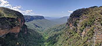 The plateau of Kings Tableland stretching to the left, above Jamison Valley, centre, 2008. | |
| Highest point | |
| Elevation | 1,000 m (3,300 ft) |
| Coordinates | 33°49′S 150°24′E / 33.817°S 150.400°ECoordinates: 33°49′S 150°24′E / 33.817°S 150.400°E [1] |
| Geography | |
| Parent range | Blue Mountains Range |
| Geology | |
| Mountain type | Sydney sandstone plateau |
The Kings Tableland is a plateau, located in the Blue Mountains of New South Wales, Australia. The Tableland is an eroded remnant of a sandstone layer that is approximately 1,000 metres (3,300 ft) AMSL, situated immediately south of Wentworth Falls. The Tableland is the major southerly spur of the main spine of the Blue Mountains Range and forms the beginning of the Southern Escarpment, an unbroken series of tall sandstone cliffs which fringes the Jamison, Megalong, Kanimbla and Hartley Valleys.[2]
Situated to the west of the locality of Blue Labyrinth, Kings Tableland extends from Bodington Hill south to McMahons Lookout and further about 4.8 kilometres (3.0 mi). The plateau was named by Governor Macquarie after King George III.[1]
Indigenous significance
A portion of the Kings Tablelands has been gazetted as a camping and meeting place of significance for the Aboriginal Gandangara people. The conserved area includes a sandstone rock platform with extensive grinding and other grooves, a shelter with rock art that has been recorded as being the oldest Aboriginal site in the Blue Mountains region and containing unique vertically engraved depictions of kangaroo and bird tracks.[3][4]
Modern developments
A road from Wentworth Falls runs north and south along the plateau to the current lookout area of McMahons Point. Before the construction of Warragamba Dam the track continued down the escarpment along a track all the way to the Cox's River area in the Burragorang Valley.[5] There is a track descending from the western edge down into the Jamison Valley, originally leading to the old (now abandoned) sewerage works below the cliffs at Katoomba. The abandoned Queen Victoria Hospital is also located on Kings Tableland.
Gallery
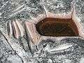 Grinding grooves, Aboriginal site, 2009.
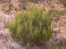 Allocasuarina nana, commonly known as the Dwarf She-Oak, found on Kings Tablelands, 2011.
See also
![]() Media related to Blue Mountains, New South Wales at Wikimedia Commons
Media related to Blue Mountains, New South Wales at Wikimedia Commons
References
- 1 2 "Kings Tableland". Geographical Names Register (GNR) of NSW. Geographical Names Board of New South Wales. Retrieved 1 July 2013.
- ↑ "Report on Kings Tableland, Wentworth Falls". City Planning Branch. City of Blue Mountains. November 2006. p. 3. Retrieved 1 July 2013.
- ↑ "Atlas of Aboriginal Places: Kings Tableland". Office of Environment & Heritage. Government of New South Wales. 21 May 2013. Retrieved 1 July 2013.
- ↑ "The Greater Blue Mountains Area: World Heritage Nomination" (PDF). prepared by the NSW National Parks & Wildlife Service in association with Environment Australia. Commonwealth of Australia. 1998. p. 49. Retrieved 1 July 2013.
- ↑ Heritage listing of Old Road
External links
- Smith, Jim (2009). "New insights into Gundungurra place naming". In Koch, Harold. Aboriginal Placenames: Naming and Re-Naming the Australian Landscape (PDF). Canberra: Australian National University. pp. 87–114. ISBN 9781921666087.