Lapstone Zig Zag
| Knapsack Viaduct | |
|---|---|
 | |
| Crosses | Knapsack Gully |
| Heritage status | Heritage listed |
| Characteristics | |
| Material | sandstone |
| Total length | 388 feet (118 m) |
| Height | 120 feet (37 m) |
| Longest span | 5 of 55 ft |
| Number of spans | 7 |
| History | |
| Designer | John Whitton[1] |
| Constructed by | W. Watkins |
| Construction begin | 1863 |
| Construction end | 1865 |
| Opened | 1867 |
The Lapstone Zig Zag[2] was a zig zag railway built near Lapstone on the Great Western Railway of New South Wales in Australia between 1863 and 1865, to overcome an otherwise insurmountable climb up the eastern side of the Blue Mountains.[3][4] The ruling grade was already very steep at 1 in 33 (3%).[5] The original plan had been to build the whole line across the Blue Mountains on a completely different route through the Grose Valley with a 3 km long tunnel, but this was beyond the resources of the colony of New South Wales at the time.[5] The track included a now abandoned station called Lucasville which was built for the Minister for Mines, John Lucas who had a holiday home nearby.[6]
History
Nineteenth century

The rail route across the mountains extended as far as Wentworth Falls (then called "Weatherboard") by 1867[7] but the Lapstone Zig Zag, which included Lucasville station, soon ran into problems: the length of the top points and bottom points limited the length of trains and the single track meant that trains travelling in opposite directions had to stop at crossing points. The first crossing point after Lapstone Zig Zag was at Wascoe's Siding at what is now Glenbrook. The single track would contribute to a fatal accident at Emu Plains in 1878 where eastbound and westbound goods trains collided.[3] A deviation including a tunnel was built around 1890 to replace the zig zag, but it too experienced problems as it was built at too steep a grade causing the locomotives to slip, and smoke became a problem for uphill trains.[3] The building of the tunnel is the subject of Arthur Streeton's famous painting Fire's On.[8]
Twentieth century
By 1910, the line as a whole was being duplicated (made into double track) and the "rathole" tunnel was replaced on a different deviation with a gentler alignment with 1 in 60 (1.67%) grades and the Glenbrook tunnel. From then on the lower section of the track, including the historic Knapsack Gully Viaduct, was converted into a road, the Great Western Highway, the main road up the Lapstone hill until the M4 motorway replaced it in 1993.[9] The older tunnel was converted for mushroom growing but was also used by the RAAF for storage during World War II.[10] During 1943 to 1946 Glenbrook tunnel stored chemical weapons .
Present day
The line of the old track and cuttings (including the long abandoned platform of Lucasville station), and the old Knapsack Gully bridge is now a popular bushwalking track.[11] Often a cacophony of birdsong and insects can be heard where the gully is deep at the viaduct and it would tend to echo these sounds, especially that of the bell miner. Although the original tunnel is closed there is also a bush walk that will take you close to its entrance.[10][12]
Knapsack_Viaduct-3.jpg) Knapsack Viaduct, detail
Knapsack Viaduct, detail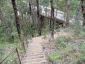 Stairway descent to viaduct from Siding Lookout
 Marker plate on trig. point, indicating distances.
Lucasville_platform_and_steps.jpg) Remains of Lucasville Station and steps
Remains of Lucasville Station and steps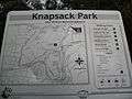 Knapsack Park guide
See also
References
- ↑ "Knapsack Viaduct, Lapstone". Heritage NSW. Retrieved 15 August 2014.
- ↑ The Ascents of Lapstone Hill Singleton, C.C. Australian Railway Historical Society Bulletin, September, 1956 pp117-131
- 1 2 3 John Low (1991) Pictorial Memories Blue Mountains Kingsclear Books
- ↑ "Glenbrook Blue Mountains". Glenbrook Blue Mountains. 2010-03-21. Archived from the original on 1 Apr 2009. Retrieved 2011-12-05.
- 1 2 Bayley, William A. (William Alan) (1980), Blue Mountains railways, Austrail Publications, ISBN 978-0-909597-23-8
- ↑ "Glenbrook Blue Mountains". Glenbrook Blue Mountains. 2010-03-21. Archived from the original on 1 Apr 2009. Retrieved 2011-12-05.
- ↑ "Visiting a park | NSW National Parks". Nationalparks.nsw.gov.au. 2011-11-28. Retrieved 2011-12-05.
- ↑ "Artist's Footsteps". Artistsfootsteps.com. Retrieved 2011-12-05.
- ↑ David Martin - Blue Mountains (2010-02-28). "Lapstone Hill Railway Routes- Blue Mountains, Australia". Infobluemountains.net.au. Retrieved 2011-12-05.
- 1 2 Blue Mountains Railway Pages - David Martin (1912-12-09). "Glenbrook's old Railway Tunnel - Blue Mountains". Infobluemountains.net.au. Retrieved 2011-12-05.
- ↑ "Wildwalks". AU-NS: Wildwalks. Retrieved 2011-12-05.
- ↑ "Bushwalking on the Lapstone train tunnel walk hiking trail". AU-NS: Wildwalks.com. Retrieved 2011-12-05.
| Wikimedia Commons has media related to Lapstone Zig Zag. |
Additional references
- Bayley, William A. (William Alan) (1972), Lapstone zig zag railway, Austrail Publications, ISBN 978-0-909597-07-8
- Full Steam Across The Mountains - Phil Belbin & David Burke - Methuen Australia 1981
External links
Coordinates: 33°46′00″S 150°37′00″E / 33.76667°S 150.61667°E Category:Stone bridges in Australia