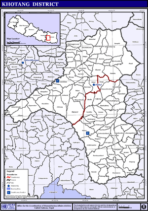
Khotang District
| Khotang खोटाङ | |
|---|---|
| District | |
 | |
| Country | Nepal |
| Region | Eastern (Purwanchal) |
| Zone | Sagarmatha |
| Headquarters | Diktel |
| Area | |
| • Total | 1,591 km2 (614 sq mi) |
| Population (2011 [1]) | |
| • Total | 206,312 |
| • Density | 130/km2 (340/sq mi) |
| Time zone | NPT (UTC+5:45) |
| Website | official website |
Khotang District (Nepali: खोटाङ जिल्ला![]() Listen ), a part of Province No. 1, is one of the seventy-five districts of Nepal, a landlocked country of South Asia. The district, with Diktel as its district headquarters, covers an area of 1,591 km² and has a population (2011) of 206,312.[1] Khotang is part of the area traditionally called Majh Kirat/Kirant (middle Kirat), home to indigenous ethnic Kirat Rai people. Apart from Rais, other ethnic groups and hill castes live in Khotang.
Listen ), a part of Province No. 1, is one of the seventy-five districts of Nepal, a landlocked country of South Asia. The district, with Diktel as its district headquarters, covers an area of 1,591 km² and has a population (2011) of 206,312.[1] Khotang is part of the area traditionally called Majh Kirat/Kirant (middle Kirat), home to indigenous ethnic Kirat Rai people. Apart from Rais, other ethnic groups and hill castes live in Khotang.
Geography and climate
| Climate Zone[2] | Elevation Range | % of Area |
|---|---|---|
| Lower Tropical | below 300 meters (1,000 ft) | 0.7% |
| Upper Tropical | 300 to 1,000 meters 1,000 to 3,300 ft. |
31.5% |
| Subtropical | 1,000 to 2,000 meters 3,300 to 6,600 ft. |
49.1% |
| Temperate | 2,000 to 3,000 meters 6,400 to 9,800 ft. |
16.3% |
| Subalpine | 3,000 to 4,000 meters 9,800 to 13,100 ft. |
1.6% |
Municipalities and Village Development Committees (VDC))
Ainselu Kharka, Arkhale, Badahare, Badka Dipali Bahunidanda, Bakachol, Baksila, Bamrang, Barahapokhari, Baspani, Batase, Bijaya Kharka, Buipa, Chhitapokhari, Chhorambu, Chipring, Chisapani, Chyandanda, Chyasmitar, Damarkhu Shivalaya, Dandagaun, Devisthan, Dharapani, Dhitung, Diktel Municipality, Dikuwa, Diplung, Dipsung, Dorpa Chiuridanda, Dubekol, Dumre Dharapani, Durchhim, Hanchaur, Indrayani Pokhari, Jalapa, Jyamire, Kahalle, Kaule, Kharmi, Kharpa, Khartamchha, Khidima, Khotang Bazar, Kubhinde, Laphyang, Lamidanda, Lichki Ramche, Linkuwa Pokhari, Magpa, Mahadevasthan, Mangaltar, Mattim Birta, Mauwabote, Nerpa, Nirmalidada, Nunthala, Patheka, Pauwasera, Phaktang, Phedi, Rajapani, Rakha Bangdel, Rakha Dipsung, Ratancha Majhagaun, Ribdung Jaleshwari, Ribdung Maheshwari, Salle, Santeshwar Chhitapokhari, Sapteshwar, Saunechaur, Sawakatahare, Simpani, Solma, Sungdel, Suntale, Woplukha, Wopung, Yamkhya
References
- 1 2 Household and population by districts, Central Bureau of Statistics (CBS) Nepal
- ↑ The Map of Potential Vegetation of Nepal - a forestry/agroecological/biodiversity classification system (PDF), . Forest & Landscape Development and Environment Series 2-2005 and CFC-TIS Document Series No.110., 2005, ISBN 87-7903-210-9, retrieved Nov 22, 2013 horizontal tab character in
|series=at position 91 (help)
- "Districts of Nepal". Statoids.
Coordinates: 27°12′N 86°47′E / 27.200°N 86.783°E
| Wikimedia Commons has media related to Khotang District. |