Kern River Canyon
| Kern River Canyon | |
|---|---|
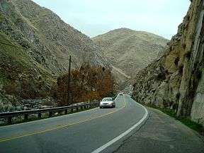
|
Kern River Canyon from SR 178, near the canyon floor. Kern River is visible on the left. | |
| Location | Kern County, California |
| Floor elevation | 800 to 2,400 feet (240 to 730 m) |
| Long-axis direction | East/West |
| Long-axis length | 20 miles (32 km) |
| Width | 1 mile (1.6 km) at top |
| Depth | 1,500 to 2,000 feet (460 to 610 m) |
| Geography | |
| Coordinates | 35°41′45″N 118°40′4″W / 35.69583°N 118.66778°WCoordinates: 35°41′45″N 118°40′4″W / 35.69583°N 118.66778°W |
| Traversed by | State Route 178 |
The Kern River Canyon is a canyon in Kern County, California. It is located in the Southern Sierra Nevada.
The canyon was formed by the Kern River, and connects the Kern River Valley and southern San Joaquin Valley.[1] California State Route 178 (Kern Canyon Road) follows the canyon, from east of Bakersfield up to the Lake Isabella area.
References
- ↑ Lee, Charles. An Intensive Study of the Water Resources of a Part of the Owens Valley, California. United States Geological Survey - United States Department of the Interior. Government Printing Office. 1912. Page 49.
This article is issued from Wikipedia - version of the 9/28/2015. The text is available under the Creative Commons Attribution/Share Alike but additional terms may apply for the media files.
