K-39 (Kansas highway)
| ||||
|---|---|---|---|---|
 | ||||
| Route information | ||||
| Maintained by KDOT | ||||
| Length: | 65.03 mi (104.66 km) | |||
| Major junctions | ||||
| West end: |
| |||
| East end: |
| |||
| Location | ||||
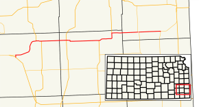
| Counties: | Wilson, Neosho, Bourbon | |||
| Highway system | ||||
| ||||

K-39 is a 65.03-mile-long (104.66 km) state highway in the U.S. state of Kansas. It is an east–west highway, and connects Fort Scott to towns in southeast Kansas.
Route description
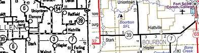
K-39 begins seven miles (11 km) north of Fredonia at U.S. Highway 400 (US-400). It travels east to Benedict, where it turns north toward Buffalo. South of town, K-39 meets US-75 and begins a short, one-mile-long (1.6 km) concurrency with the U.S. Highway. Once leaving US-75, the highway again travels east toward Chanute, where it intersects US-169. The highway continues east 12 miles (19 km) before beginning a seven-mile-long (11 km) concurrency with US-59. After briefly turning north with US-59, K-39 resumes its easterly route north of Stark. The highway shares a very short overlap with K-3 (less than one mile, 1.6 kilometers) and passes through Hiattville before meeting its eastern terminus at K-7, which completes the connection to US-69.[1]
History
K-39 has been at its current alignment since 1999.[2] Prior to that the western terminus was located near Elk City. The portion of the route between Elk City and Fredonia are now county owned roads. Before 1956, when K-39 was modernized, a large portion of the route was unpaved and used 90 degree turns to travel northeast instead of the current diagonal alignment.[3]
Major Junctions
| County | Location | mi[4] | km | Destinations | Notes |
|---|---|---|---|---|---|
| Wilson | | 0.0 | 0.0 | Western terminus | |
| Buffalo | 14.8 | 23.8 | Western end of US-75 concurrency | ||
| | 15.7 | 25.3 | Eastern end of US-75 concurrency | ||
| Neosho | Chanute | 26.3 | 42.3 | ||
| | 39.1 | 62.9 | Western end of US-59 concurrency | ||
| Stark | 46.3 | 74.5 | Eastern end of US-59 concurrency | ||
| Bourbon | | 56.2 | 90.4 | Western end of K-3 concurrency | |
| | 56.8 | 91.4 | Eastern end of K-3 concurrency | ||
| | 65.032 | 104.659 | Eastern terminus | ||
1.000 mi = 1.609 km; 1.000 km = 0.621 mi
| |||||
See also
 Kansas portal
 U.S. Roads portal
References
- ↑ Kansas Department of Transportation (2015). There's No Place Like Kansas: Official State Transportation Map (PDF) (Map) (2015–16 ed.). Scale not given. Topeka: Kansas Department of Transportation. Retrieved August 1, 2015.
- ↑ Kansas Department of Transportation (1999). Kansas Official State Transportation Map (PDF) (Map) (1999–2000 ed.). Scale not given. Topeka: Kansas Department of Transportation. Retrieved August 1, 2015.
- ↑ State Highway Commission of Kansas (1945). Travel Kansas: Crossroads of a Continent (PDF) (Map). Scale not given. Topeka: State Highway Commission of Kansas. Retrieved August 1, 2015.
- ↑ Kansas Department of Transportation (2014). "2014 Condition Survey Report". Topeka: Kansas Department of Transportation. Retrieved August 1, 2015.