Jigme Dorji National Park
Coordinates: 27°45′N 89°31′E / 27.750°N 89.517°E
| Jigme Dorji National Park | |
| Protected Area | |
| Name origin: Jigme Dorji Wangchuck | |
| Country | Bhutan |
|---|---|
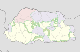
| District | Gasa, Paro, Punakha, Thimphu, Wangdue Phodrang |
| Highest point | |
| - elevation | 7,000 m (22,966 ft) |
| Lowest point | |
| - elevation | 1,400 m (4,593 ft) |
| Area | 4,316 km2 (1,666 sq mi) |
| Animal | blue sheep, takin, snow leopard, musk deer, Himalayan black bear, Bengal tiger, and red panda |
| Date | 1974 |
 | |
| Website: Bhutan Trust Fund for Environmental Conservation | |
The Jigme Dorji National Park, named after the late Jigme Dorji Wangchuck, is the second-largest National Park of Bhutan. It occupies almost the entire Gasa District, as well as the northern areas of Thimphu District, Paro District, Punakha, and Wangdue Phodrang Districts. It was established in 1974 and stretches over an area of 4316 km², thereby spanning all three climate zones of Bhutan, ranging in elevation from 1400 to over 7000 meters. About 6,500 people in 1,000 households live within the park, from subsistence agriculture and animal husbandry. It is listed as a tentative site in Bhutan's Tentative List for UNESCO inclusion.[1][2]
Flora and fauna
The park provides sanctuary for 37 known species of mammals including several endangered, threatened or vulnerable species, such as the takin, snow leopard, clouded leopard, Bengal tiger, bharal or Himalayan blue sheep, black musk deer, Himalayan black bear, red panda, Ussuri dhole, and spotted linsang. It is also home to the Indian leopard, serow, sambar, barking deer, goral, marmot, pika and more than 300 species of birds. It is also the only park in Bhutan where the national animal (takin), flower (blue poppy), bird (raven) and tree (cypress) exist together.[1][2]
Cultural sites
Jigme Dorji also contains sites of cultural and economic significance. Mount Jomolhari and Mount Jitchu Drake are worshipped as homes of the local deity. The fortresses of Lingshi Dzong and Gasa Dzong are sites of historical importance. The rivers Mo Chhu, Wangdi Chhu and Pa Chhu have their sources in the glacial lakes located in the park.[2][3]
Glaciers
Jigme Dorji National Park covers most of northern Gasa District, including the bulk of Lunana and Laya Gewogs. These gewogs are the site of some of the most notable and precarious glaciers of Bhutan. These glaciers have thawed significantly over the course of recorded history, causing lethal and destructive glacial lake outburst floods. Chief among the glaciers and glacial lakes within the park are Thorthormi,[4][5] Luggye,[6] and Teri Kang.[7] As the seasons allow, temporary camps of laborers work within the park to reduce water levels to assuage the threat of flooding downstream.[6]

See also
| Wikimedia Commons has media related to National parks of Bhutan. |
References
- 1 2 "Parks of Bhutan". Bhutan Trust Fund for Environmental Conservation online. Bhutan Trust Fund. Retrieved 2011-03-26.
- 1 2 3 "Jigme Dorji National Park". Himalaya 2000 online. Bhutan Travel Guide. Retrieved 2011-04-02.
- ↑ "Parks" (PDF). Protected Areas Programme. 9 (3). IUCN – The World Conservation Union. October 1999. Retrieved 2011-03-26.
- ↑ Pelden, Sonam (3 September 2010). "Thorthormi water level brought down 43 cm". Bhutan Observer online. Retrieved 2011-03-27.
- ↑ Choden, Kuenzang C (21 August 2009). "A major GLOF in 2010?". Bhutan Observer online. Retrieved 2011-03-27.
- 1 2 Pelden, Sonam (9 October 2009). "Thorthormi water level brought down". Bhutan Observer online. Retrieved 2011-03-27.
- ↑ "Snowman Trek I (to Sephu)". Tourism Council of Bhutan online. Government of Bhutan. 26 August 2008. Retrieved 2011-04-24.
