Janakpur Zone
| Janakpur जनकपुर अञ्चल | |
|---|---|
| Zone | |
 | |
| Country | Nepal |
| Region | Eastern Development Region |
| Area | |
| • Total | 9,669 km2 (3,733 sq mi) |
| Population (2001) | |
| • Total | 2,557,004 |
| • Density | 264.5/km2 (685/sq mi) |
| Time zone | Nepal Time (UTC+5:45) |
Janakpur (Nepali: जनकपुर अञ्चल ![]() Listen ) is one of the fourteen zones of Nepal, reaching from the Indian border in the south to the Tibetan border in the north and Sagarmatha Zone in the east and Bagmati and Naryani Zones in the west.
Listen ) is one of the fourteen zones of Nepal, reaching from the Indian border in the south to the Tibetan border in the north and Sagarmatha Zone in the east and Bagmati and Naryani Zones in the west.
The headquarters of Janakpur Zone and its main city is Janakpur. Close to the Indian border, it is a historic city of Hinduism. The city was believed to be the capital city of King Janak, the father in law of Lord Rama, the son of the then king of Ayodhya, Dasharatha. The city was then called 'Mithila Nagari'. The name of this zone is related to the historic King Janak and his capital Janakpur.
Other cities within Janakpur Zone are Kamalamai (in Inner Terai) and Bhimeshwor and Bardibas, Dhalkebar, Jaleshwor, Malangwa, Gaushala Bazar and Matihani (Outer Terai).
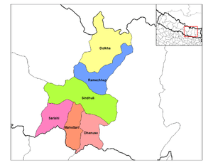
Districts
Janakpur is divided into six districts:
See also
| Eastern Region (Purwanchal) | ||
|---|---|---|
| Central Region (Madhyamanchal) | ||
| Western Region (Pashchimanchal) | ||
| Mid-Western Region (Madhya Pashchimanchal) | ||
| Far-Western Region (Sudur Pashchimanchal) | ||
Coordinates: 27°10′N 85°55′E / 27.167°N 85.917°E
