Interstate 380 (Iowa)
| ||||
|---|---|---|---|---|
|
Iowa's Interstate Highways with I-380 highlighted in red. | ||||
| Route information | ||||
| Auxiliary route of I-80 | ||||
| Maintained by Iowa DOT | ||||
| Length: | 73.080 mi[1] (117.611 km) | |||
| Existed: | ca. September 19, 1973[2] – present | |||
| History: | Under construction 1973–1985 | |||
| Major junctions | ||||
| South end: |
| |||
| ||||
| North end: |
| |||
| Highway system | ||||
| ||||
.svg.png)
_map.svg.png)
Interstate 380 (I-380) is a 73-mile (117 km) auxiliary Interstate Highway located in eastern Iowa. The route extends from Interstate 80 near Coralville to Waterloo. I-380 connects the cities of Cedar Rapids and Waterloo, the second- and sixth-largest cities in the state, respectively, to the Interstate Highway System. Except for its last 1 1⁄2 miles (2.4 km) north of U.S. Route 20 (US 20), I-380 runs concurrent with Iowa Highway 27, which represents Iowa's portion of the 560-mile (900 km) Avenue of the Saints Highway connecting St. Louis, Missouri, with St. Paul, Minnesota.
Construction of I-380 took 12 years to complete, ending in 1985. After the interstate opened, US 218 was moved onto the new freeway. In the 1990s, the I-380 corridor was selected as part of the Avenue of the Saints corridor, which Iowa designated as Iowa Highway 27 in 2001. I-380 has been affected by two major floods, the Great Flood of 1993 and the Iowa flood of 2008, both of which closed the road at the Iowa River for two weeks.
Route description
Interstate 380 begins at a cloverleaf interchange where US 218 and Iowa 27 cross Interstate 80 in Coralville in Johnson County. From the interchange, I-380, US 218, and Iowa 27, the route assigned to the Avenue of the Saints Highway in Iowa, run together towards Cedar Rapids. The interstate heads north and serves North Liberty. North of North Liberty, the freeway runs parallel to the former routing of US 218 and Iowa 965; here the two highways cross the Iowa River. After crossing into Linn County, the three routes enter the Cedar Rapids city limits near The Eastern Iowa Airport. Three miles (4.8 km) north of the airport, I-380 intersects US 30 and US 151 at a cloverstack interchange. At this interchange, US 218 splits away from I-380 and Iowa 27.[3]
Through Cedar Rapids, the I-380 freeway is elevated relative to the nearby streets and residential neighborhoods. As it approaches downtown and the Cedar River, the freeway takes a tight, 90-degree turn to the east, crosses the river, squeezes between a Quaker Oats plant and the U.S. Cellular Center before turning back 90 degrees to the north. Between downtown and the Coldstream–29th Street interchange, I-380 serves as a dividing line between residential areas to the east and industry to the west. Towards the north end of Cedar Rapids, industry is replaced with commerce as I-380/Iowa 27 meet Iowa 100, locally known as Collins Road, at a volleyball interchange. The collector/distributor ramps for Collins Road also serve the same function for Blairs Ferry Road, the next overpass to the north.[4]
The freeway leaves Cedar Rapids and enters Hiawatha, where there is only one interchange, a diamond with Boyson Road. Quickly escaping the Cedar Rapids area, I-380 turns to the northwest and passes through predominantly rural areas with small communities and farms dotting the way. Because of its northwestern angle, I-380 enters four counties within 30 miles (48 km), as counties in Iowa are generally rectangular in shape. It passes Center Point in northwestern Linn County, Urbana in northeastern Benton County, where it meets Iowa 150, and Brandon in southwestern Buchanan County. The interstate travels into Black Hawk County heading northwest for 7 miles (11 km) before turning north for 3 miles (4.8 km) until a directional T interchange with US 20.[3]
Together with US 20, I-380 and Iowa 27 travel west towards Waterloo and Cedar Falls. The three routes pass the eastern Waterloo suburbs of Raymond, Evansdale, and Elk Run Heights. Almost immediately after crossing the Cedar River again, I-380 splits away from US 20 and Iowa 27 and rejoins US 218 at a three-level stack interchange. I-380 and US 218 head north to the east of the Crossroads Center shopping mall.[5] One half-mile (0.8 km) north of the interchange which serves the Crossroads Center, I-380 ends at the traffic light at Mitchell Avenue. US 218 continues to the north at this point.[1]
History
The first section of I-380 opened to traffic on September 19, 1973. That section connected The Eastern Iowa Airport to I-80 at Coralville. Within three years, the interstate had been extended into Cedar Rapids at the Cedar River. The bridge which crossed the river would not open until June 1979. By the end of 1981, I-380 was a continuous road to the Coldstream Avenue/Glass Road interchange.[2] The interstate was originally scheduled to be open by Christmas 1984, but weather delays pushed back the construction timetable.[6] The last section of I-380 to be completed opened on September 12, 1985.[7]
| Wikinews has related news: Flooding closes highways in eastern Iowa, US |
In 1985, US 218 was bypassed around Iowa City and Coralville, joining I-380 at the I-80 interchange. US 218 to Cedar Rapids was replaced by Iowa 965.[8] In the early 1990s, most of I-380 was designated as part of the Avenue of the Saints corridor, which connects St. Louis, Missouri, to St. Paul, Minnesota. Avenue of the Saints route markers were erected along the route the next year. In August 2001, the Avenue of the Saints in Iowa was given a single designation, Iowa 27, to facilitate following the route through the state.[9]
I-380 crosses two of Iowa's major rivers, the Iowa and the Cedar. Both rivers have affected the interstate during major floods, as the case was in 1993 and in 2008. During the Great Flood of 1993, I-380 and Iowa 965 were both closed at the Iowa River's Coralville Lake reservoir between July 13 and July 28.[10] The roads reopened after the lake's waters receded enough to allow Department of Transportation inspectors to check the three bridges over the water.[11]
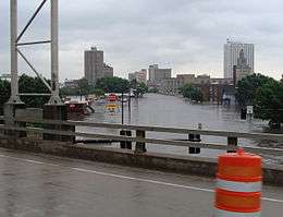
The great Iowa flood of 2008 affected the same section of I-380 at the Iowa River in much the same fashion as in 1993. I-380 and former Iowa 965 were closed at the Iowa River on June 13 until July 3.[12] In Cedar Rapids, flooding did not close I-380, the only bridge not to close, though traffic was restricted through the city.[13] The flooding damage was much more severe in Cedar Rapids than in Iowa City. The Cedar River crested at over 31 feet (9.4 m) on June 13, causing hundreds of millions of dollars in damage.[14]
Exit list
| County | Location | mi[1] | km | Exit[3] | Destinations | Notes | |
|---|---|---|---|---|---|---|---|
| Johnson | Coralville | Southern end of US 218/Iowa 27 overlap; continuation south of interchange | |||||
| 0.000 | 0.000 | 0 | Southern terminus and signed as exits 0A (eastbound) and 0B (westbound), no numbering northbound; I-80 exits 239A-B | ||||
| North Liberty | 4.046 | 6.511 | 4 | ||||
| Jefferson Township | 10.857 | 17.473 | 10 | ||||
| Linn | Cedar Rapids | 13.186 | 21.221 | 13 | Ely, The Eastern Iowa Airport | ||
| 16.329 | 26.279 | 16 | Northern end of US 218 overlap; northbound exits signed 16A (eastbound) and 16B (westbound) | ||||
| 17.585 | 28.300 | 17 | 33rd Avenue SW – Hawkeye Downs | ||||
| 18.329 | 29.498 | 18 | Wilson Avenue SW | ||||
| 19.415 | 31.245 | 19A | Northbound exit and southbound entrance only | ||||
| 19.747 | 31.780 | 19B-C | No southbound entrance, northbound exit signed as exit 19C | ||||
| 20.159 | 32.443 | 20A | Southbound exit and northbound entrance only | ||||
| 20.652 | 33.236 | 20B | Access to Mercy Medical Center and St. Luke's Hospital | ||||
| 21.563 | 34.702 | 21 | H Avenue, J Avenue | ||||
| 22.346 | 35.962 | 22 | Coldstream–29th Street, Glass Road – 32nd Street | ||||
| 23.371 | 37.612 | 23 | 42nd Street | Southbound exit from exit 24 | |||
| 23.879 | 38.430 | 24 | Signed as exits 24A (Iowa 100) and 24B (Blairs Ferry Road) northbound | ||||
| Hiawatha | 25.270 | 40.668 | 25 | Boyson Road | |||
| Monroe Township | 28.847 | 46.425 | 28 | ||||
| Center Point | 35.824 | 57.653 | 35 | ||||
| Benton | Urbana | 41.867 | 67.378 | 41 | Urbana | ||
| 43.525 | 70.047 | 43 | |||||
| Buchanan | Jefferson Township | 49.954 | 80.393 | 49 | Brandon | ||
| 55.348 | 89.074 | 55 | |||||
| Black Hawk | Fox Township | 62.222 | 100.137 | 62 | |||
| Poyner Township | 65.013 | 104.628 | 65 | Southern end of US 20 overlap | |||
| 66.449 | 106.939 | 66 | Raymond, Gilbertville | ||||
| Evansdale | 68.357 | 110.010 | 68 | Evansdale Drive – Elk Run Heights | |||
| 70.625 | 113.660 | 70 | River Forest Road | ||||
| Waterloo | 71.432 | 114.959 | 71 | Northern end of US 20/Iowa 27 overlap; Southern end of US 218 overlap; Signed as exit 71A (US 218) and 71B (US 20/Iowa 27) | |||
| 72.499 | 116.676 | 72 | Access to Covenant Medical Center | ||||
| 73.080 | 117.611 | Northern end of US 218 overlap; continuation beyond northern end | |||||
1.000 mi = 1.609 km; 1.000 km = 0.621 mi
| |||||||
References
- 1 2 3 "2010 Volume of Traffic on the Primary Road System of Iowa" (PDF). Iowa Department of Transportation. January 1, 2010. Retrieved January 12, 2011.
- 1 2 Completion Map of Interstate System (PDF) (Map). Iowa Department of Transportation. January 1, 1982. Retrieved January 12, 2011.
- 1 2 3 Transportation Map (PDF) (Map). Iowa Department of Transportation. 2010. Retrieved January 12, 2011.
- ↑ Highway and Street Map of Cedar Rapids, Iowa (PDF) (Map). Iowa Department of Transportation. July 7, 2008. Retrieved January 12, 2011.
- ↑ Waterloo and Cedar Falls, Iowa (PDF) (Map). Iowa Department of Transportation. 2010. Retrieved January 12, 2011.
- ↑ "Buchanan County Leg of I-380 Lags". Telegraph-Herald. Dubuque. UPI. February 23, 1984. p. 15. Retrieved January 14, 2011.
- ↑ The National System of Interstate and Defense Highways (PDF). Iowa Department of Transportation. April 29, 1996. p. 7.
- ↑ Iowa State Highway Map (Map). Iowa Department of Transportation. 1985.
- ↑ Iowa Department of Transportation. "Avenue of the Saints". Retrieved January 13, 2011.
- ↑ "Chronology (Floods)". The Gazette. Cedar Rapids. p. A13.
- ↑ Gosch, Dave (July 27, 1993). "Change in the weather – really". The Gazette. Cedar Rapids. p. A1.
- ↑ "I-380 segment south of Cedar Rapids being closed". The Courier. Waterloo – Cedar Falls. Archived from the original on January 12, 2011. Retrieved January 12, 2011.
- ↑ Gravelle, Steve (June 19, 2008). "Bridges opened; water rules eased". The Gazette. Cedar Rapids. p. F2A.
- ↑ Belz, Adam (June 14, 2008). "C.R. struggles to grasp losses". The Gazette. Cedar Rapids. p. F1A.
External links
| Wikimedia Commons has media related to Interstate 380 (Iowa). |
- Iowa Department of Transportation – I-380 time lapse flooding
- Iowa Highways – Interstate 380
- Interstate 380 Iowa @ Interstate-Guide.com
| ||